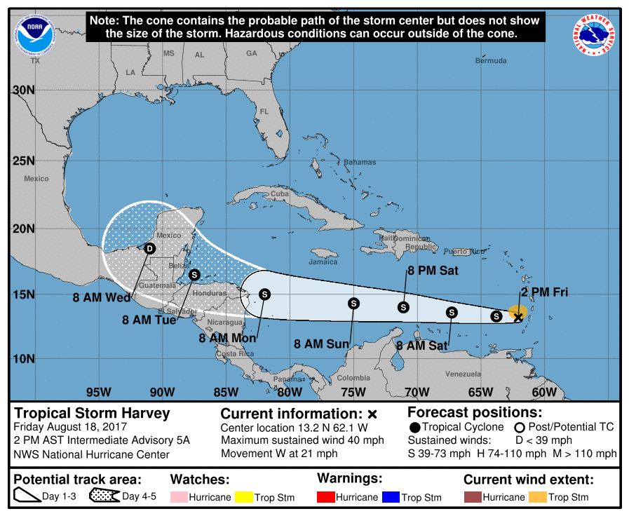
Tropical Storm Harvey continues to head west today after clearing the Windward Islands earlier. According to the National Hurricane Center, the structure of Harvey has changed little during the past several hours, and overall the storm is poorly organized. The low-level center is near the eastern edge of the convective mass due to the affects of vertical wind shear. In addition, surface observations and Air Force Reserve Hurricane Hunter data suggest that the disconnected 850 mb center is located west or southwest of the surface center. Based on the aircraft and surface data, the central pressure is near 1005 mb.
Harvey is forecast to continue its westward journey over the next several days. A strong low- to mid-level ridge north of the cyclone should keep Harvey on this general motion for the next 3-4 days, with the system moving from the eastern to the western Caribbean Sea during this time. Towards the early to mid part of next week, a more northerly motion is expected when Harvey passes near or over portions of Central America, the Yucatan Peninsula, and eastern Mexico.
The National Hurricane Center continues to forecast that this system will strengthen over time. For now, they expect the system to not gain hurricane strength over its life cycle, but the NHC confidence in intensity forecasts for this storm is low at this time.
Harvey is not expected to directly impact the US, but residents should be on alert as the peak of the season nears in the coming weeks. Before any threat arrives on US shores, residents should make sure their Hurricane Action Plan is in order.
Experts believe this Atlantic Hurricane Season, which runs through to the end of November, will be a busy one. Dr. Phil Klotzbach and the experts at Colorado State University updated their seasonal outlook again on July 5, showing a much more active than normal season expected. The National Oceanic and Atmospheric Administration (NOAA) also released their own forecast which shows this hurricane season to be likely more active than others.