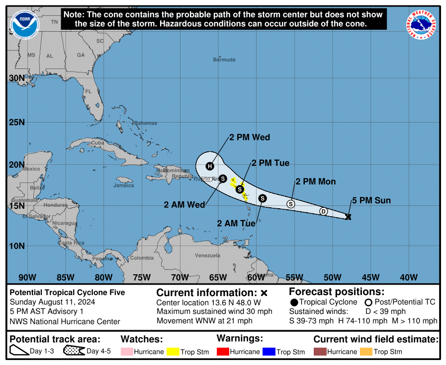
The National Hurricane Center has classified an area of disturbed weather in the central Atlantic as Potential Tropical Cyclone #5; with the forecast developing that system into a tropical storm in the coming days, Tropical Storm Watches have been issued for portions of the Leeward Islands.
As of the latest advisory from the National Hurricane Center, the disturbance was centered near latitude 13.6 North, longitude 48.0 West and moving toward the west-northwest near 21 mph and this motion is expected to continue during the next couple of days. On the forecast track, the disturbance is expected to move across portions of the Leeward Islands on Tuesday and approach the U.S. and British Virgin Islands Tuesday night.
A variety of different governments have issued watches for their respective islands. The government of France has issued a Tropical Storm Watch for Guadeloupe and St. Martin. The government of Antigua has issued a Tropical Storm Watch for St. Kitts, Nevis, Montserrat, Antigua, Barbuda, and Anguilla. The government of the Netherlands has issued a Tropical Storm Watch for Saba and St. Eustatius. The government of Sint Maarten has issued a Tropical Storm Watch for Sint Maarten.
A Tropical Storm Watch means that tropical storm conditions are possible within the watch area, generally within 48 hours.
“Interests elsewhere in the Leeward Islands, British and U.S. Virgin Islands, and Puerto Rico should monitor the progress of Potential Tropical Cyclone Five. Additional watches could be required tonight or early Monday,” warns the National Hurricane Center.
The system is expected to become a tropical depression tonight and a tropical storm by tomorrow. When the system is upgraded to a tropical storm, it will be named Ernesto. Until then, it will simply be known as “Potential Tropical Cyclone Five.”
The system should bring heavy rain, gusty winds, and rough surf to the islands in its path. Total rain accumulations of 1-2″ for the Windward Islands, 4-6″ over the northern Leeward Islands, and 3-6″ for Puerto Rico is expected, with maximum amounts up to 10″ possible. Tropical storm force wind conditions are possible within the watch area beginning Tuesday. Swells generated by the system will likely begin to affect portions of the Leeward Islands beginning Monday night. These swells are likely to cause life threatening surf and rip current conditions.