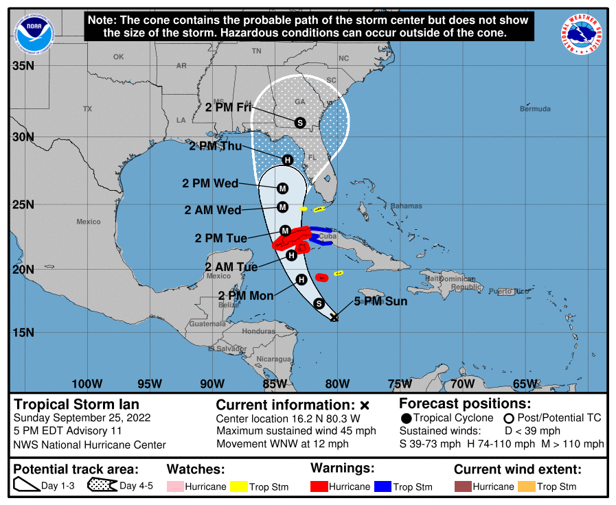
Tropical Storm Watches are now in effect for portions of Florida as hurricane concerns build in the southeastern United States. While Tropical Storm Ian has not improved its structure or intensity much today, meteorologists with the National Hurricane Center continue to forecast that it will soon begin a period of significant intensification as it moves north.
With storm impacts possible in as little as 48 hours, the National Hurricane Center has issued a Tropical Storm Watch for the lower Florida Keys from Seven Mile Bridge southward to Key West, including the Dry Tortugas. This watch could be upgraded with time.
A Hurricane Warning is also in effect for Grand Cayman and the Cuban provinces of Isla de Juventud, Pinar del Rio, and Artemisa. A Tropical Storm Warning is in effect for the Cuban provinces of La Habana, Mayabeque, and Matanzas. In addition the portions of the Keys, a Tropical Storm Watch is also up for Little Cayman and Cayman Brac.
A Hurricane Warning means that hurricane conditions are expected somewhere within the warning area. A warning is typically issued 36 hours before the anticipated first occurrence of tropical-storm-force winds, conditions that make outside preparations difficult or dangerous. Preparations to protect life and property should be rushed to completion. A Tropical Storm Warning means that tropical storm conditions are expected somewhere within the warning area within 36 hours. A Tropical Storm Watch means that tropical storm conditions are
possible within the watch area, generally within 48 hours.
Right now, Tropical Storm Ian is 220 miles south-southeast of Grand Cayman and about 495 miles southeast of the western tip of Cuba. Maximum sustained winds are down a bit to 45 mph while the pressure is holding at 1003 mb or 29.62″. The storm is moving to the west-northwest at 12 mph.
While Ian is moving toward the west-northwest now, the National Hurricane Center (NHC) expects it to turn toward the northwest tonight, followed by a north-northwestward motion on Monday and a northward motion on Tuesday with a slightly slower forward speed. On the forecast track, the center of Ian is expected to pass near or west of the Cayman Islands on Monday, and near or over western Cuba Monday night and early Tuesday. Ian will then emerge over the southeastern Gulf of Mexico on Tuesday.
The NHC expects some strengthening tonight, followed by more rapid strengthening on Monday and Tuesday. Ian is forecast to become a hurricane on Monday and a major hurricane on Tuesday.

What happens beyond Cuba remains uncertain. The National Hurricane Center currently keeps the storm as a major hurricane after moving through western Cuba into the Gulf of Mexico, brushing by the Florida Keys. From there the official NHC track brings the storm north and north-northeast, bringing the storm to the Florida Gulf coast as a hurricane during the middle or later part of the week. The NHC forecast cone suggest that landfall can occur as far west as Pensacola on the panhandle to as far south/east as Sanibel Island and Naples on the Florida gulf coast. The most likely landfall point is between those two areas, but the NHC cautions that there can still be significant changes with both the track and intensity forecasts for this storm.