• Skip to primary navigation
  • Skip to main content
  • Skip to primary sidebar

Weatherboy

Weatherboy Weather News, Maps, RADAR, Satellite, and Forecasts.

  • Local
  • Earth Science News
  • RADAR
  • Current Warnings
  • Satellite
  • Current Maps
  • Forecast Maps
  • Video

Uncertainty Lingers in Extended Forecast

by Weatherboy Team Meteorologist - November 29, 2018

While this afternoon's run of the American GFS FV3 shows a potent winter storm moving through the East Coast around December 8 and 9, a lack of model to model and run to run consistency leaves meteorologist with low confidence in the computer forecast data.  Image: TropicalTidbits.com
While this afternoon’s run of the American GFS FV3 shows a potent winter storm moving through the East Coast around December 8 and 9, a lack of model to model and run to run consistency leaves meteorologist with low confidence in the computer forecast data. Image: TropicalTidbits.com


With an active weather pattern, there’s a lot of potential for winter storms to form along the eastern United States as December gets underway. However, forecast models that meteorologists use to aid with forecasting weather remain conflicted, each offering up very different solutions for how the weather pattern will evolve in the coming week.

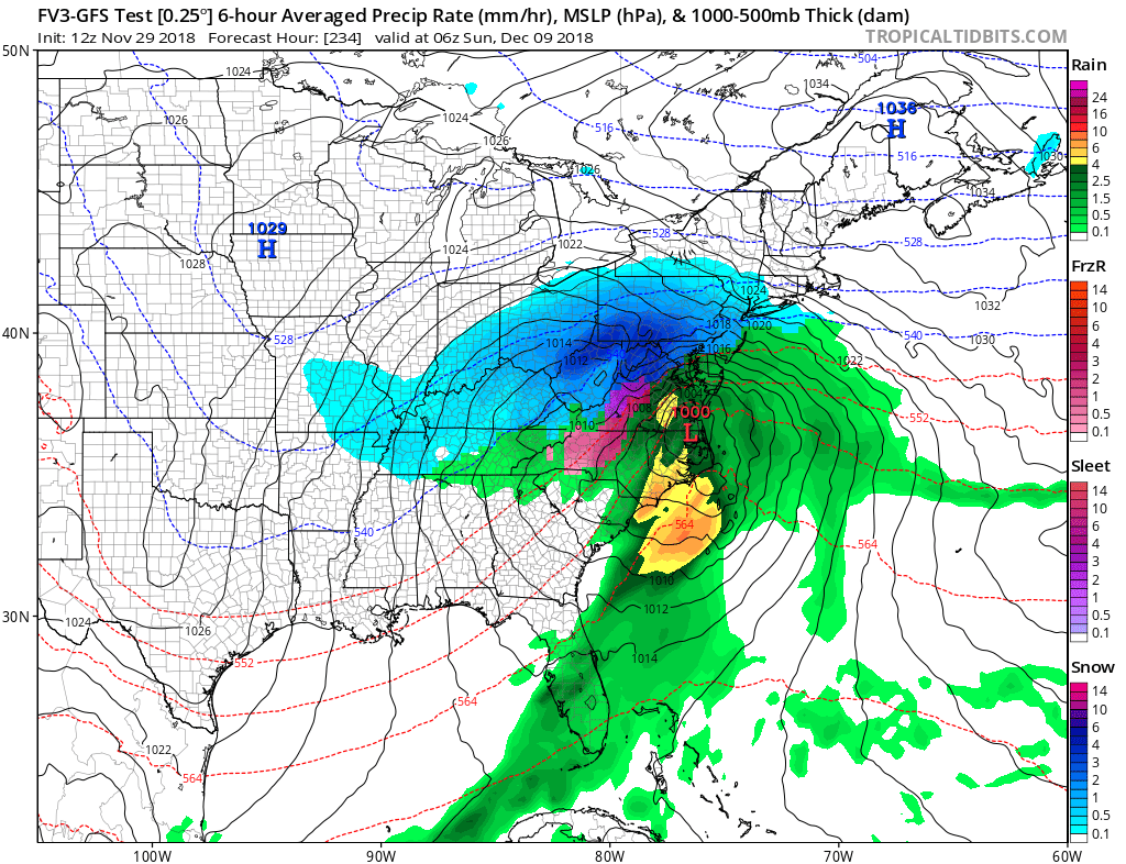
Some forecast models have been quite bullish with creating a significant coastal snowstorm for the northeast in early December. The American GFS suggested this afternoon that heavy snow would fall across the Mid Atlantic and New England around December 8/9. However, runs before and after that particular model output are very different, with the afternoon run being the most amplified solution. In addition to being inconsistent from run to run, the American GFS model is also out on its own with such a solution. Other global guidance, such as the ECMWF forecast model, offers a very different possibility, with a rain maker moving up into New England. The European forecast model has also hinted at the chance of a light snow event in the Mid Atlantic around December 5, but is also lacking run to run consistency of such a solution.


With models lacking consistency with each other and with their own runs, meteorologists put low confidence in any particular storm scenario. Model data comes out around the day, with two significant runs made late at night and in the afternoon, East Coast Time.  As these potential storm threats near, it is likely there will be better agreement with forecast models and the meteorologists that use them.


Primary Sidebar

Sponsored Ad

Search

Latest News

  • Weak Earthquake Strikes Knoxville, Tennessee
  • Warnings Issued as Florida Freeze Approaches
  • Snow Possible in Florida This Weekend
  • Fired TV Weatherman Becomes Political Firestorm
  • East Coast Snow Storm Threat Fizzles …for Now
  • Popular Florida TV Meteorologist Matt Devitt Fired; Tens of Thousands Express Anger
  • Fresh Earthquake Rattles Louisiana Today
  • Threat of Mid Atlantic and Northeast Winter Storm Growing
About | Careers | Contact | Contests
Terms | Privacy | Ad Choices
Weatherboy is a (R) Registered Trademark of isarithm LLC, All Rights Reserved.
All content herein is Copyright by Isarithm LLC 1997-2022

Insert/edit link

Enter the destination URL

Or link to existing content

    No search term specified. Showing recent items. Search or use up and down arrow keys to select an item.