The National Hurricane Center (NHC) and the Canadian Hurricane Center have expanded the area under watches and warnings with Hurricane Lee expected to impact the region this weekend. While Lee is forecast to weaken, it is also forecast to widen, bringing about strong winds and storm surge threats far away from the center of the storm.
The Tropical Storm Warning along the coast of New England has been extended northward to the U.S./Canada border. The Tropical Storm Warning along the coast of Massachusetts has been extended westward to Westport while the Tropical Storm Watch west of Westport, Massachusetts has been discontinued. The Storm Surge Watch for Cape Cod Bay and Nantucket has also been. In Canada, the Canadian Hurricane Center has extended the Tropical Storm Watch along the coast of eastern Nova Scotia to Point Tupper.
With these changes made, a Hurricane Watch is in effect for the area between Stonington, Maine to the U.S./Canada border, New Brunswick from the U.S./Canada border to Point Lepreau, including Grand Manan Island, and for Nova Scotia from Digby to Medway Harbour. A Hurricane Watch means that hurricane conditions are possible within the watch area. A watch is typically issued 48 hours before the anticipated first occurrence of tropical storm-force winds, conditions that make outside preparations difficult or dangerous.
A Tropical Storm Warning is in effect for Bermuda, the area from Westport, Massachusetts northward to the U.S./Canada border, for Martha’s Vineyard, and for Nantucket. A Tropical Storm Watch is in effect for New Brunswick from north of Point Lepreau to Fort Lawrence, Nova Scotia west coast from north of Digby to Fort Lawrence, and Nova Scotia southeast coast from north of Medway Harbour to Point Tupper. A Tropical Storm Warning means that tropical storm conditions are expected somewhere within the warning area within 36 hours. A Tropical Storm Watch means that tropical storm conditions are possible within the watch area, generally within 48 hours.
As of the latest advisory from the NHC, Hurricane Lee had maximum sustained winds of 85 mph and was located 210 miles west of Bermuda and about 665 miles south of Nantucket, Massachusetts. The storm was moving to the north at 15 mph. The minimum central pressure is 957 mb or 28.26″.
The NHC expects Lee to continue to move to the north and pick up speed by tomorrow. A turn toward the north-northeast and then northeast is forecast Saturday night and Sunday. On the forecast track, the center of Lee will pass west of Bermuda through this evening, approach the coast of New England and Atlantic Canada Friday and Saturday, and move across Atlantic Canada Saturday night and Sunday.
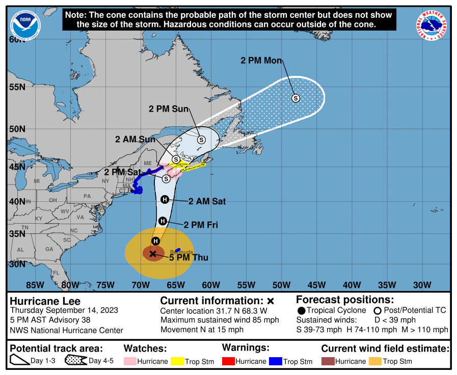
For now, the NHC expects little change in strength in Lee through Friday afternoon. Some gradual weakening is forecast Friday night and Saturday, but Lee is expected to remain large and dangerous for the next couple of days.
Lee is a large hurricane. Hurricane-force winds extend outward up to 105 miles from the center and tropical-storm force winds extend outward up to 345 miles.
Tropical storm conditions will continue on Bermuda through Friday morning. Hurricane conditions are possible in the Hurricane Watch areas in Down East Maine and in Atlantic Canada on Saturday. Tropical storm conditions are expected to begin in the southern New England on Friday afternoon and spread northward within the Tropical Storm Warning area through Saturday. Tropical storm conditions are possible in the Tropical Storm Watch area in Atlantic Canada by late Friday into Saturday.
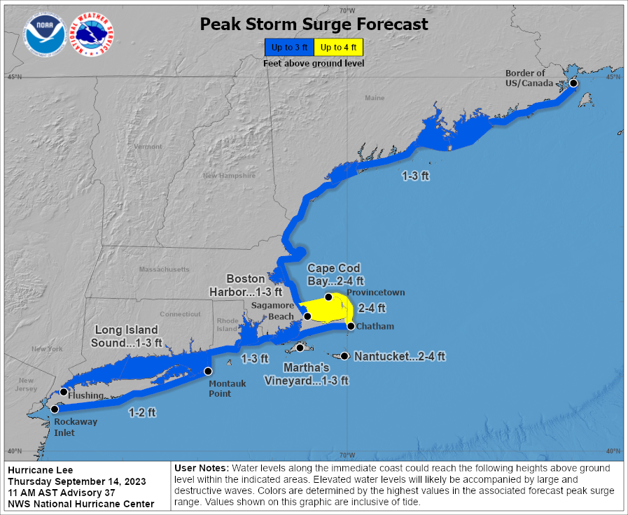
The combination of storm surge and tide will cause normally dry areas near the coast to be flooded by rising waters
moving inland from the shoreline. A storm surge of 1-3′ is possible from Flushing, NY to the U.S./Canada Border, including Long Island Sound. A surge of 1-2′ is possible between Rockaway Inlet and Montauk Point. The deepest water will occur along the immediate coast where the surge will be accompanied by large and destructive waves. Surge-related flooding depends on the relative timing of the surge and the tidal cycle, and can vary greatly over short distances. A dangerous storm surge could produce coastal flooding within the wind watch areas in Atlantic Canada in areas of onshore winds. Near the coast, the surge will be accompanied by large and destructive waves.
Swells generated by Lee are affecting portions of the Lesser Antilles, the British and U.S. Virgin Islands, Puerto Rico, Hispaniola, the Turks and Caicos Islands, the Bahamas, Bermuda, the east coast of the United States, and Atlantic Canada. These swells are likely to cause life-threatening surf and rip current conditions. Even expert swimmers and surfers should avoid the ocean until Lee’s hazards pass.
Friday night through Saturday night, Lee is expected to produce rainfall amounts of 1-4″ across portions of eastern New England into portions of New Brunswick and Nova Scotia. This may produce localized urban and small stream flooding.
