The National Hurricane Center has expanded watches tied to Hurricane Erin north up the East Coast with Hurricane Erin getting larger and closer to the coast. While Hurricane Erin is not forecast to make landfall on Bermuda or the U.S. East Coast, it will be large enough to impact both with gusty winds, destructive surf, storm surge flooding, and even heavy rain showers as the outer fringes of the storm circle around the storm center.
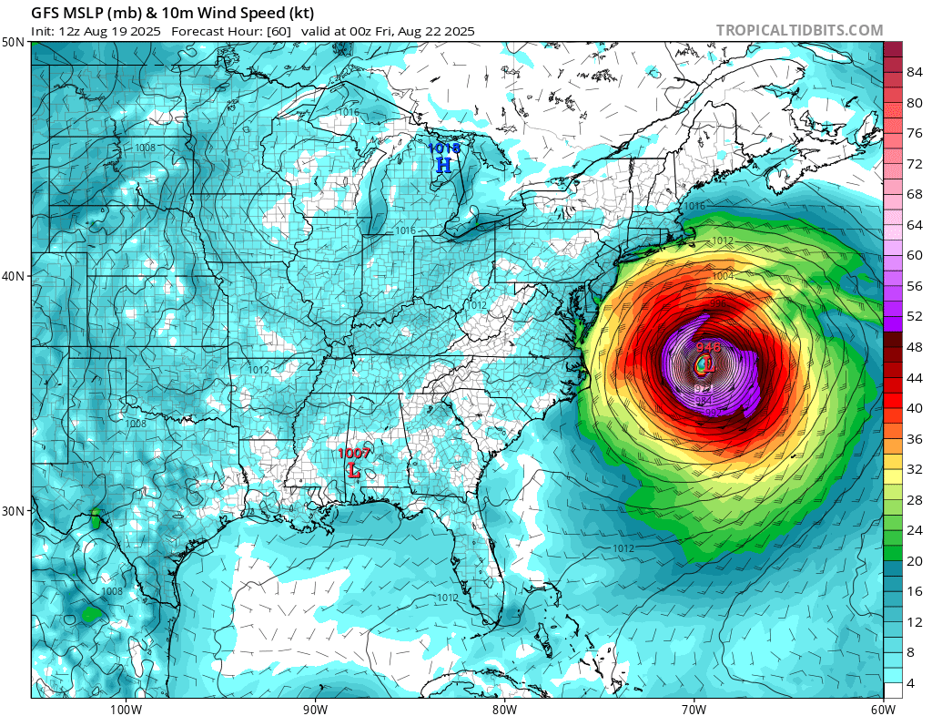
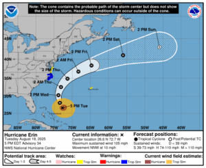
As of the latest update from the National Hurricane Center (NHC), Hurricane Erin is located about 615 miles southwest of Bermuda and 615 miles south-southeast of Cape Hatteras, North Carolina. The minimum central pressure is 958 mb or 28.29″.
Erin is moving toward the north-northwest near 10 mph and the NHC says this motion with an increase in forward speed is expected through tonight followed by a northward motion on Wednesday and then a northeastward motion on Thursday. On the forecast track, the center of Erin will pass to the east of the Bahamas tonight and then move over the western Atlantic between the U.S. east coast and Bermuda on Wednesday and Thursday. Maximum sustained winds are near 105 mph now with higher gusts. Some fluctuations in intensity are possible during the next couple of days.
Erin is a large hurricane and is forecast to even become larger. Hurricane-force winds extend outward up to 80 miles from the center and tropical-storm-force winds extend outward up to 230 miles. The width of tropical storm force winds is expected to grow almost three times larger to 600 miles by Friday.
With the storm getting larger, tropical storm force winds are now possible over a larger area, as is the threat of storm surge flooding. Because of that, the National Hurricane Center has extended some watches.
The Tropical Storm Watch is now extended northward along the U.S. Atlantic coast north of Cape Charles Light, Virginia to Chincoteague, Virginia.
The Bermuda Weather Service has also issued a Tropical Storm Watch for Bermuda.
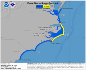
Meanwhile, a Storm Surge Warning is in effect the area from Cape Lookout to Duck, North Carolina. A Tropical Storm Warning is in effect for the are between Beaufort Inlet, North Carolina to Duck, North Carolina including the Pamlico and Albemarle sounds.
A Tropical Storm Watch means that tropical storm conditions are possible within the watch area, generally within 48 hours.
A Storm Surge Warning means there is a danger of life-threatening inundation, from rising water moving inland from the coastline, during the next 36 hours; upwards of 2-4′ of storm surge is possible. The deepest water will occur along the immediate coast where the surge will be accompanied by large and dangerous waves. Surge-related flooding depends on the relative timing of the surge and the tidal cycle, and can vary greatly over short distances.
While the worst of the wind and rain will remain over water, some of it will impact some land.
Rainfall will be diminishing across the Turk and Caicos and the Bahamas this evening. Heavy rainfall is possible on the Outer Banks of North Carolina Wednesday night into Thursday with the potential for 1-2″.
Tropical storm force wind conditions are expected over portions of the North Carolina Outer Banks beginning late Wednesday or Wednesday night. Tropical storm conditions are possible in the watch area north of Duck, North Carolina to Cape Charles Light beginning Thursday. Tropical storm conditions are possible in Bermuda beginning Thursday.
Swells generated by Erin will affect the Bahamas, Bermuda, the east coast of the United States, and Atlantic Canada during the next several days. These rough ocean conditions are expected to cause life-threatening surf and rip currents. Even the most experienced swimmers and surfers should avoid the ocean until the storm is long gone. For
information specific to your area, please see products issued by
your local National Weather Service forecast office.
