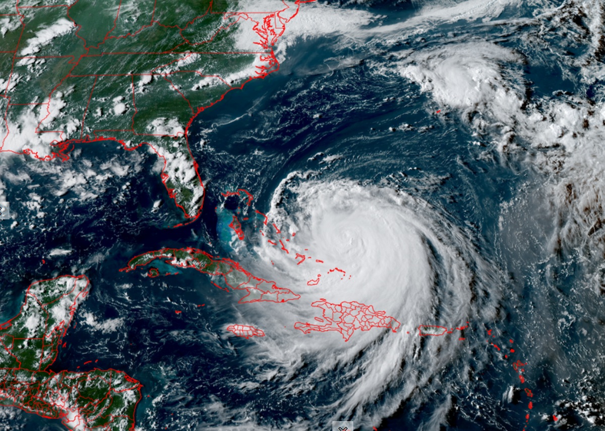
As Hurricane Erin spins about in the eastern Atlantic Ocean, it is forecast by the National Hurricane Center to grow in size as it approaches the U.S. East Coast, prompting watches to be issued and evacuations to be ordered.
In addition to the Tropical Storm Watch that was previously issued for the Turks and Caicos Islands and the southeast Bahamas, the National Hurricane Center has issued a Tropical Storm Watch for North Carolina from Beaufort Inlet to Duck including the Pamlico Sound. A Tropical Storm Warning means that tropical storm conditions are
expected somewhere within the warning area imminently while a Tropical Storm Watch means that tropical storm conditions are possible within the watch area, generally within 48 hours.
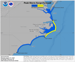
In addition to the Tropical Storm Watch, a Storm Surge Watch has also been issued from Cape Lookout to Duck, North Carolina. A Storm Surge Watch means there is a possibility of life-threatening inundation, from rising water moving inland from the coastline during the next 48 hours.
Due to the threat from Erin, North Carolina authorities have started to issue Mandatory Evacuations for portions of the coast. In Dare County, Hatteras Island is under an Evacuation Order. All visitors were to begin evacuating today at 10 am; residents are to start evacuating no later than 7 am tomorrow. In Hyde County, all Ocracoke Island visitors and non resident property owners were to evacuate starting 8 pm last night. Remaining residents were told to evacuate starting 8 am today.
A 2-4 storm surge is expected along the coast where the evacuation orders are up, even though Erin isn’t expected to make landfall here.

While Erin isn’t expected to make a direct hit to the U.S. East Coast, it is forecast to grow significantly in size. The National Hurricane Center says the storm is now about 370 miles wide from southeast to northwest in terms of where the tropical storm force winds are. In less than 5 days they expect the storm to grow to 600 miles across. Because it’ll be growing as it passes between the U.S. East Coast and Bermuda, both are expected to be brushed by outer bands of showers, gusty winds, and extremely rough surf.
As of the latest advisory from the National Hurricane Center (NHC), Erin was located about 695 miles southwest of Bermuda and 815 miles south-southeast of Cape Hatteras, North Carolina. Maximum sustained winds were 140 mph while minimum central pressure was 937 mb or 27.67″.
The NHC says that a turn to the north is expected on Tuesday. On the forecast track, the core of Erin is expected to pass to the east of the southeastern and central Bahamas today and tonight, and move between Bermuda and the east coast of the United States by the middle of the week.
With maximum sustained winds of 140 mph with higher
gusts, Erin is a category 4 hurricane on the Saffir-Simpson Hurricane Wind Scale. The NHC says Erin is likely to remain a dangerous major hurricane through the middle of this week.
“Erin is an unusually large hurricane,” says the NHC. “Hurricane-force winds extend outward up to 80 miles from the center and tropical-storm-force winds extend outward up to 230 miles.”
The outer bands of Erin will produce localized areas of heavy rainfall across portions of Hispaniola this evening and through Tuesday for the Turks and Caicos, the southeast Bahamas, and the easternmost central Bahamas. Additional rainfall of 2-4″ with locally higher amounts to 6″ are forecast.
Tropical storm force wind conditions are expected through this evening across the Turks and Caicos Islands and the southeast Bahamas. Tropical storm conditions are possible in portions of the central Bahamas tonight through Tuesday. Tropical storm conditions are possible over portions of the North Carolina Outer Banks beginning late Wednesday.

Swells generated by Erin will affect the Bahamas, Bermuda, the east coast of the United States, and Atlantic Canada during the next several days. These rough ocean conditions will likely cause life-threatening surf and rip currents.
Minor coastal flooding is possible in areas of onshore winds in the Turks and Caicos Islands and the southeast Bahamas. Near the coast, the surge will be accompanied by large waves. The combination of a dangerous storm surge and the tide will cause normally dry areas near the coast to be flooded by rising waters moving inland from the shoreline. The water could reach up to 4′ in portions of the North Carolina coast. The deepest water will occur along the immediate coast where the surge will be accompanied by large and dangerous waves.
The NHC says, “Surge-related flooding depends on the relative timing of the surge and the tidal cycle, and can vary greatly over short distances.”
