As was suggested by forecast models yesterday, it is likely a weaker nor’easter scenario is likely to impact portions of the Northeast, with New Jersey and New York among the states expected to see the worst. But weaker doesn’t mean non-event, and meteorologists with the National Weather Service are warning that a variety of major impacts are still on the table, especially for vulnerable coastal locations that will see the worst of the storm.
A strong coastal low will continue to develop tonight into tomorrow, bringing significant coastal impacts to the East Coast: coastal flooding, high surf, damaging winds, and heavy rain.
The combination of strong onshore winds, high surf, and high astronomical tides will likely lead to major coastal flooding in the Mid-Atlantic, especially along the coasts of the Delmarva and southern New Jersey. Impacts could include flooded roadways and structures near the water front.

“Coastal residents are urged to heed warnings and follow guidance from local officials,” warns the National Weather Service’s Mount Holly, New Jersey office.
High surf is expected on many East Coast beaches which will generate strong, dangerous rip currents and likely lead to areas of beach erosion.
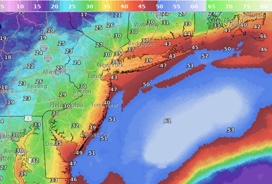
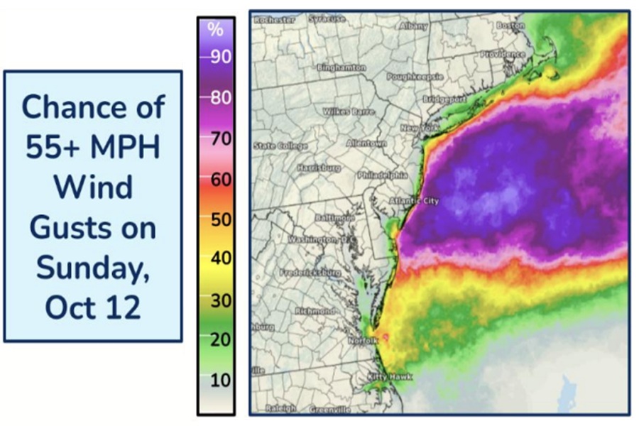
Wind gusts in excess of 55 mph along and near the Mid Atlantic and southern New England coastlines may lead to scattered power outages and damage. The National Weather Service has issued High Wind Warnings for Delaware Beaches, eastern Monmouth, Cape May, and coastal Atlantic and Ocean counties. Here, northeast winds of 30-40 mph with gusts to 60 mph are possible, with the worst of the winds expected between 11am Sunday and 6 am Monday. In New York, a High Wind Warning is also in effect for Eastern Suffolk County on Long Island, where the worst of the winds are expected between noon Sunday and 6pm Monday.
“Damaging winds will blow down trees and power lines. Power outages are expected. Travel will be difficult, especially for high profile vehicles,” warns the National Weather Service in New York, New York.
“Avoid windows during the windstorm. Watch for falling debris and tree limbs. Use caution if you must drive,” they add.
Heavy rain in the Mid-Atlantic may cause isolated to scattered instances of flash flooding. Widespread 1-3″ of rain are possible, with 2-3″ along the immediate coastline to 1-1.5″ over the I-95 corridor. Places west of I-95 will see substantially less rain with flood threats there unlikely.
Coastal areas could see a compounded impact with heavy rain on top of moderate to major tidal flooding, especially during the high tide cycle.
This will be a significant storm system and one of the more potent coastal storms to impact the region in the last several years. But with the storm track trending more off-shore than on it, much of the area, including the heavily populated I-95 corridor, will be spared the worst of it.
