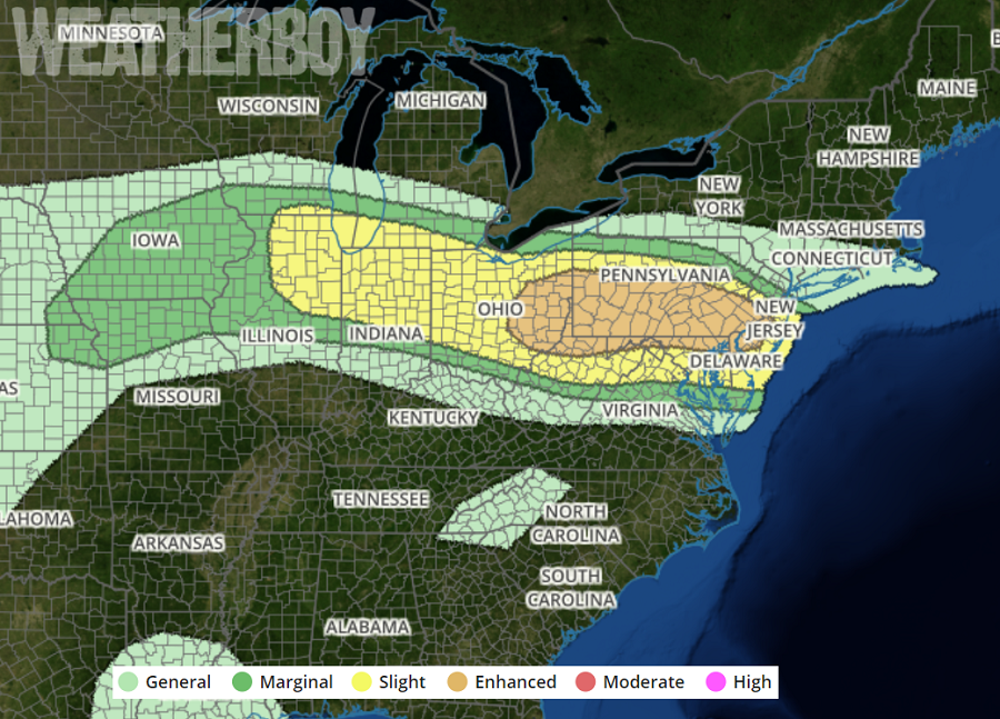
A round of severe weather is expected to develop tomorrow in portions of the northeast; so much so that the National Weather Service’s Storm Prediction Center (SPC) has issued a Convective outlook highlighting an area from Ohio to New Jersey as having an “enhanced risk” of severe storms. The enhanced risk zone covers 47,973 square miles and includes a population of 16,782,446 people. The “Enhanced” designation means numerous severe storms are possible; they’ll be more persistent and/or widespread, with a a few becoming intense. The National Weather Service defines a severe thunderstorm as one where measured wind gusts are at least up to 58mph, and/or have hail of at least 1″ in diameter, and/or a tornado exists.
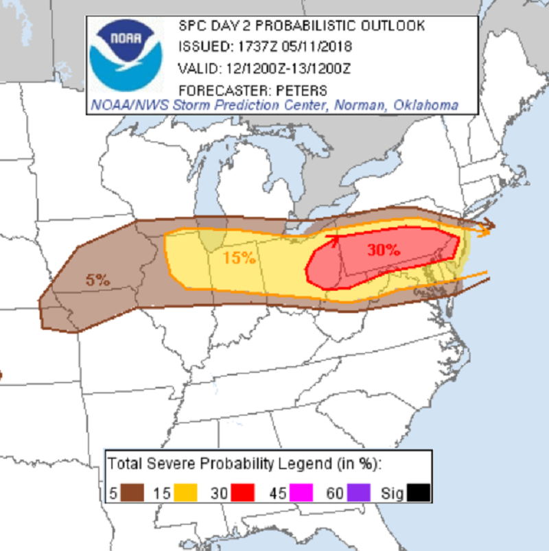
The SPC says that probabilities and categorical risk for severe storms have been upgraded across the upper Ohio Valley to the Mid Atlantic region. “Boundary layer moistening is expected in advance of the southward advancing surface boundary, while strong diabatic heating and the eastern extent of a steep mid-level lapse rate plume contribute to moderate instability across the warm sector Saturday afternoon”, they caution. “Moderately strong deep-layer west-northwesterlies suggest line segments and bowing structures will be the primary storm mode, though effective bulk shear of 35-45kt indicates embedded supercells will also be possible.”
In layman’s terms, there is increasing concern and confidence for several swaths of damaging winds across the upper Ohio Valley to the northern Mid Atlantic region. Conditions will be especially ripe during a time of peak afternoon heating for severe thunderstorm development.
Beyond severe storms, the SPC is also concerned about tornadoes. The SPC warns, “A tornado threat will be possible across northern Maryland into southeast Pennsylvania and adjacent New Jersey and Delaware, as low-level shear increases to the east and northeast of a surface low tracking into Maryland and along the warm front.” This means in addition to Severe Thunderstorm Watches and Warnings being issued, it may become necessary to also issue Tornado Watches and Warnings for the area tomorrow too.
With the threat of severe weather arriving, people in the threatened region should make sure they pay attention to evolving weather conditions during Saturday and be ready to take immediate action to protect life and property should watches or warnings be issued.
