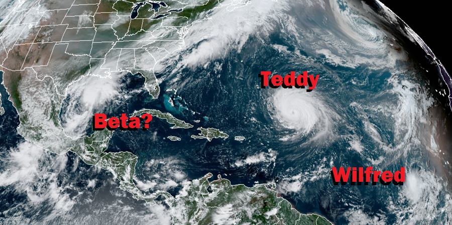
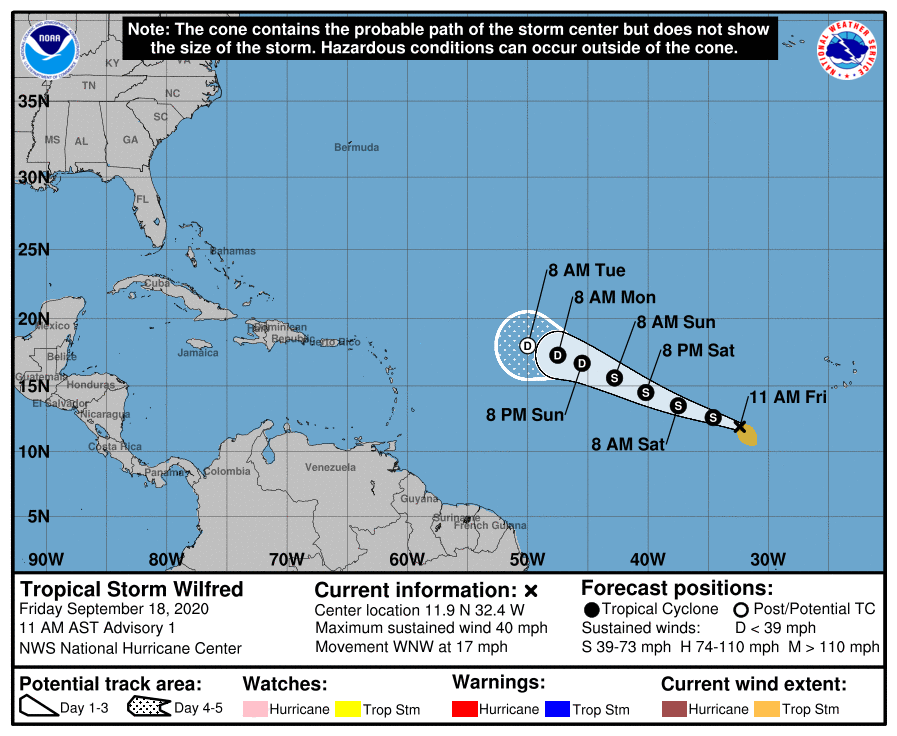
The National Hurricane Center in Miami, Florida has exhausted the list of names available to it for the 2020 Atlantic Hurricane Season, declaring a tropical wave in the eastern Atlantic to Tropical Storm Wilfred. With Tropical Depression #22 getting better organized in the Gulf of Mexico, it was initially thought it would become a storm first and earn the name Wilfred. With the Atlantic system taking the last available name first, the National Hurricane Center has started a process where storms are named after letters in the Greek alphabet from this point on.
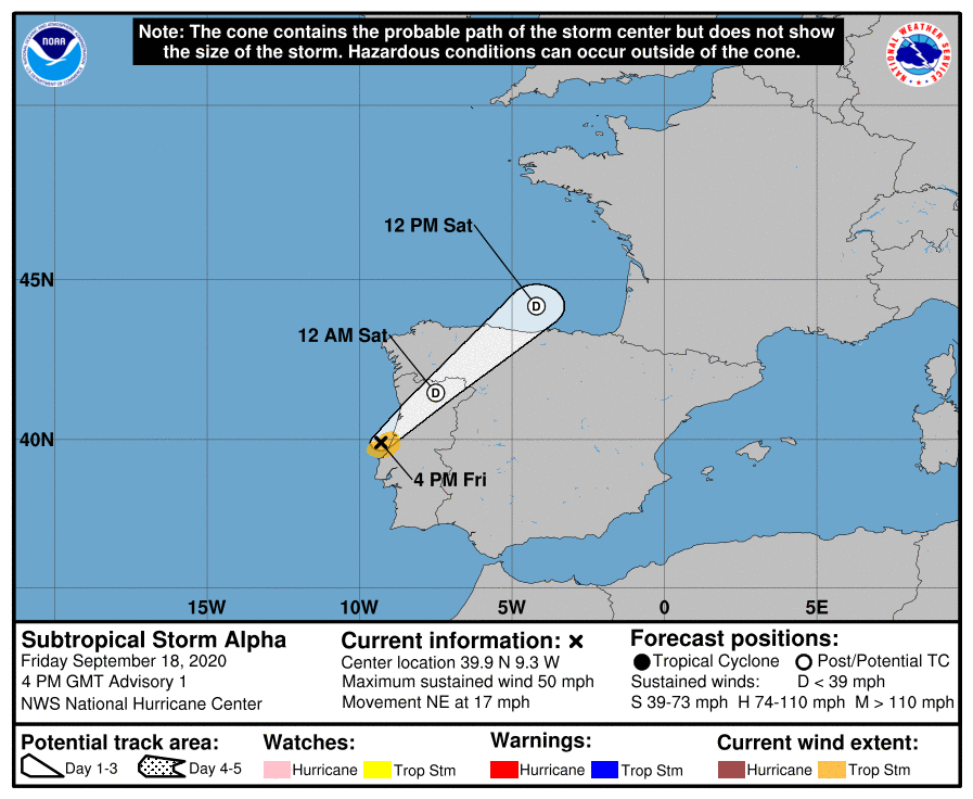
And yet another system has beat the Gulf system to the punch for the next name: Subtropical Storm Alpha has formed near the coast of Portugal. .Alpha is expected to be a short-lived system but it will bring gusty winds and heavy rain to Portugal tonight. Right now, Alpha is located about 75 miles north of Lisbon, Portugal and is moving to the northeast at 17 mph; landfall is imminent. Alpha has a minimum central pressure of 999 mb or 29.50 inches and maximum sustained winds of 50 mph. Alpha is a small storm; winds of 40 mph extend outward up to only 35 miles from the center.
Tropical Storm Wilfred is also expected to be a short-lived system. Right now, it’s located about 630 miles west-southwest of the Cabo Verde Islands and has maximum sustained winds of 40 mph making it a minimal tropical storm. It is moving to the west-northwest at 17 mph and has a minimum central pressure of 1008 MB or 29.77 inches. While the National Hurricane Center says some slight strengthening is possible today, they expect weakening to begin this weekend and continue into next week. By the middle of next week, Wilfred could dissipate.
A more immediate threat to the United States will be what happens with Tropical Depression #22 in the Gulf of Mexico. The National Hurricane Center expects the system to become stronger this afternoon, becoming a tropical storm tonight. When that happens, it would be named Tropical Storm Beta. The National Hurricane Center also believes the storm will grow into a hurricane as it spins off the Texas coast. Because it will stall over the western Gulf of Mexico, it may even weaken back to tropical storm status after becoming a hurricane.
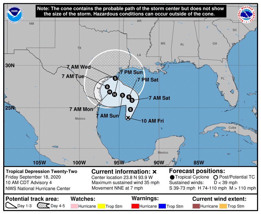
Even if it only eventually interacts with the U.S. Coast as a Tropical Storm, life-threatening, widespread flooding is becoming more likely.More than a foot of rain could fall from this system across the entire Texas coastline in the coming days. Serious flooding could also hit areas still dealing with this season’s tropical cyclone impacts of Hanna, Laura, Cristobal, and Marco.
The National Hurricane Center is also tracking two additional systems in the Atlantic Hurricane Basin that could become tropical cyclones over time. However, at this time, it is unlikely either will develop much over the next 48 hours.
The 2020 Atlantic Hurricane season runs through the end of November.
