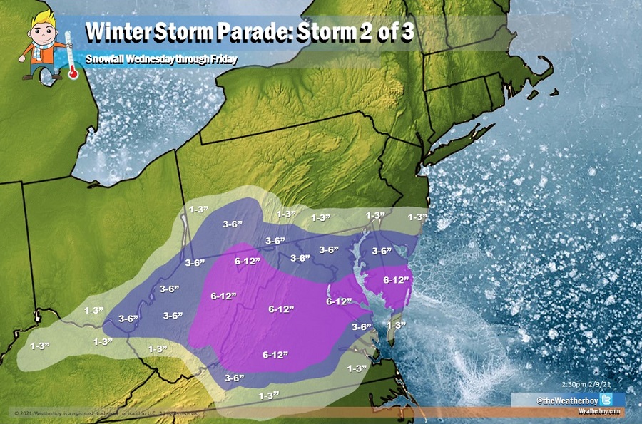
A parade of winter storms continues to march through the eastern United States. After one system brought light precipitation to portions of the northern Mid Atlantic and southern New England today, it appears system #2 will approach from the west starting late tomorrow, with snow lingering over portions of the central and southern Mid Atlantic through Friday.
A frontal zone will set-up across portions of the Mid Atlantic, setting the foundation for an area that snow will fall over the next several days. Two distinct waves of low pressure will move through this zone, creating two opportunities of snowfall within the unsettled Wednesday-Friday period. While some areas could see snow throughout the entire three day period, those on the northern side of the system may only see some snow late Wednesday/early Thursday and once again late Thursday/early Friday. And unlike past storms that pushed precipitation north into New England, high pressure over New England will keep the precipitation with this storm system well south of Scranton, PA and New York City, NY.
When all is said and done, 6-9″ of snow is likely across much of western and central Virginia. The Washington, DC and Baltimore, MD metro areas will see less snow, on the order of 3-6″. North of there, into southeastern Pennsylvania and south-central New Jersey, even less will fall with 1-3″ expected. This should be southern Delaware’s biggest snowfall of the season, with more than 6″ likely there, 3-6″ in central Delaware, and only 1-3″ in northern Delaware. Light snow is also possible in northeastern Kentucky and north-central North Carolina from this system.
The third system in this parade of winter storms is expected to impact the eastern United States this weekend. However, with precipitation amounts and types dependent on a to-soon-to-know storm track, it is too early to produce a snowfall forecast map for that system at this time.
The first system in the parade is responsible for generally light snowfall across the northeast. The National Weather Service reported these totals:
NEW JERSEY
Wantage Township 3.8″
Pellettown 3.3″
Blairstown 1.5″
Lake Hopatcong 1.2″
Oakland 1″
PENNSYLVANIA
Jessup 6″
Dallas 6″
Shavertown 5″
Scranton 5″
Kunkletown 5″
Dingmans Ferry 5″
Beach Lake 5″
Forest City 4.9″
Pittston 4.7″
Exeter 4.5″
Moosic 4″
Rossland 2.5″
New Tripoli 2.5″
Lower Towamensing Township 2″
Bushkill Township 1.2″
NEW YORK
Windsor 5″
Kiamesha 4.3″
Walden 4.1″
Whitesboro 3″
Unadilla 2.7″
Monroe 2.3″
Warwick 2″
Peekskill 2″
Binghamton 2″
Stony Point 1.8″
Cold Spring 1″
CONNECTICUT
North Granby 2.2″
Bradley Airport 1.2″
Bethel 1.2″
New Canaan 1.1″
Redding 1″
Tolland 1″
Prospect 0.5″
MASSACHUSETTS
Hubbardston 2.5″
Sterling 2.2″
Hampden 2″
Amherst 2″
Boylston 1.9″
Springfield 1.9″
Foxboro 1.6″
Russell 1.5″
Marlborough 1.2″
Nantucket 1.1″
RHODE ISLAND
North Foster 1.2″