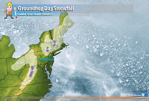
A cold front pushing through the northeast will bring clouds and rain showers, with dropping temperatures changing the rain over to snow for some. Unlike the relatively light snow event earlier this week which dropped more than 6″ of snow on Long Island and southeastern New England, this Groundhog Day system will be especially light with many places only seeing an inch or two of snow. Some colder higher spots well away from the coast could see three or four inches of snow. Closer to the coast and in the I-95 corridor from Washington, DC to New York City, the rain is expected to turn to flurries there before drying out, with little to no accumulation expected. However, a more significant storm system may be lurking in the shadows of Groundhog’s Day.
On Groundhog’s Day, Punxsutawney Phil will need to deal with cloud cover and the potential for light falling precipitation; however, in the past, television camera lights have been bright enough to cast a shadow for the folklore festivities that day.
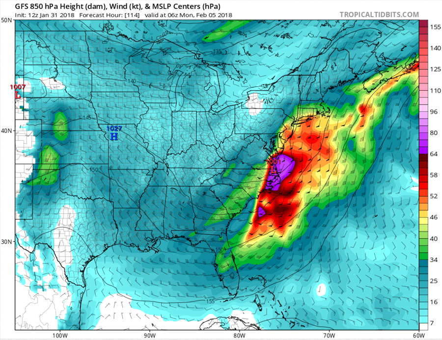
Once this light precipitation event exits the coast, a much larger weather threat looms in the not-so-distant future. A coastal low pressure system is likely to form off the southeast coast along the trailing cold front left behind by the Groundhog Day light precipitation event. This coastal system will move up the east coast late Sunday, bringing significant precipitation to the Mid Atlantic first and then the Northeast next. There are still forecast model run to run differences and differences between the forecast models regarding how the system evolves with some models indicating a stronger low tracking closer to the coast, which would favor more rain, while others indicate a weaker low farther east favoring colder temps with a better chance for snow. Without a blocking area of cold high pressure in southeastern Canada or over the northwest Atlantic, the forecast is an uncertain one. At this time, it appears the best chance for snow, which could be heavy at times, will be in inland locations well north and west from the coast. However, if the storm system stays further off-shore, the area of heavy snow could shift south and east closer to the I-95 corridor and perhaps even to the coast. The National Weather Service is officially calling for a rain/snow mix near I-95 and mainly snow in the Poconos, with snow into interior New England. It is still too soon to say with certainty how this storm will evolve until the Groundhog Day system exits.
Regardless of what happens, high pressure will briefly return late Monday into early Tuesday, keeping conditions fair. But that too will be short-lived; it appears another system will approach the northeast late Tuesday into Wednesday with even more rain or snow. While the weather pattern will be active precipitation-wise, it appears temperatures will remain near normal for the next five days.
