Today marks the first day of both the Atlantic and Central Pacific Hurricane Season; the season runs through to the end of November in both basins. While there are no hurricanes or tropical storms in either basin now, there is one area in the Gulf of Mexico that meteorologists will continue to watch in the coming days.
Recent satellite data indicate that circulation of a low pressure system located over the southern Bay of Campeche has become a little better defined today. According to the National Hurricane Center, the associated showers and thunderstorms remain disorganized. This system is expected to move slowly west-northwestward toward the coast of Mexico, and it could become a tropical cyclone before it moves inland early next week. At this time, the National Hurricane Center believes there is a 60% chance that tropical cyclone formation will occur here within the next 48 hours. The National Hurricane Center cautions though that regardless of development, the disturbance will likely produce heavy rainfall over portions of southern and eastern Mexico during the next few days. An Air Force Reserve reconnaissance aircraft is scheduled to investigate the disturbance on Sunday, if necessary. The National Hurricane Center recommends that interests along the Gulf coast of Mexico should monitor the progress of this system.
While conditions elsewhere in both the Atlantic and Central Pacific hurricane basins are quiet for now, experts from each basin are urging people to prepare ahead for what could be an active season.

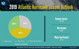
For 2019, NOAA predicts a likely range of 9 to 15 named storms (winds of 39 mph or higher), of which 4 to 8 could become hurricanes (winds of 74 mph or higher), including 2 to 4 major hurricanes (category 3, 4 or 5; with winds of 111 mph or higher). NOAA provides these ranges with a 70% confidence. An average hurricane season produces 12 named storms, of which 6 become hurricanes, including 3 major hurricanes. While the outlook describes quantities of storms and how strong they could become, it does not predict where, if at all, these storms will strike land.
Ken Graham, the Director of the National Hurricane Center, cautioned that regardless of what a seasonal outlook suggests, people should use the time before a hurricane threat arrives to prepare.
“It just takes one.” Ken Graham, Director of the @NHC_Atlantic, tells us regardless of what seasonal outlooks call for, it’s important to be prepared before the threat arrives. #HurricaneStrong? pic.twitter.com/Fu8L8NeLar
— the Weatherboy (@theWeatherboy) May 23, 2019
“With the 2019 hurricane season upon us, NOAA is leveraging cutting-edge tools to help secure Americans against the threat posed by hurricanes and tropical cyclones across both the Atlantic and Pacific,” said Secretary of Commerce Wilbur Ross. “Throughout hurricane season, dedicated NOAA staff will remain on alert for any danger to American lives and communities.”
“New satellite data and other upgrades to products and services from NOAA enable a more Weather-Ready Nation by providing the public and decision makers with the information needed to take action before, during, and after a hurricane,” said Neil Jacobs, Ph.D., acting NOAA administrator.

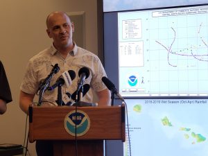
Chris Brenchley, the Central Pacific Hurricane Center Director, told reporters today that they believe there’s a 70% chance the season will be more active than usual and only a 10% chance that the season will be less active than usual. According to Brenchley, there will be 5-8 tropical cyclones this season in the Central Pacific Basin.
“This outlook reflects the forecast for El Nino to likely continue through the hurricane season. Also, ocean temperatures in the main hurricane formation region are expected to remain above-average, and vertical wind shear is predicted to be weaker-than-average,” said Gerry Bell, Ph.D., NOAA’s lead seasonal hurricane forecaster at the Climate Prediction Center, which collaborated on this outlook. Bell added, “All of these conditions point to an above-normal season.”
“As we prepare for another active hurricane season in the central Pacific, we urge everyone to have an emergency plan now, so that you are ready for the devastating impacts that a tropical cyclone could bring to the State of Hawaii,” said Chris Brenchley, director of NOAA’s Central Pacific Hurricane Center. “It is essential that you know where and how to get official information, even in the event of a power failure, and that you have your emergency supply kit ready well before any storms threaten.”
NOAA’s Central Pacific Hurricane Center (CPHC) Director, Chris Brenchley, described to us today how his Honolulu team coordinates, collaborates, & even swaps staff with Miami-based National Hurricane Center (NHC) to keep America #HurricaneStrong?@NWSHonolulu pic.twitter.com/W1WM2EeXeC
— the Weatherboy (@theWeatherboy) May 23, 2019

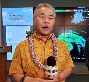
Hawaii Governor David Ige says his administration is prepared for the upcoming season, but encourages residents to do the same. “The time to prepare is now, ” Governor Ige said. People in Hawaii should be “gathering 2 weeks of emergency supplies such as non-perishable food and water, and take measures to protect (their) home against the potential impact of high winds,” the Governor added.
The Aloha State was home to multiple natural disasters in 2018. Non-tropical floods, wildfires, earthquakes, and a volcanic eruption lead to multiple emergency and disaster declarations.
The Eastern Pacific Hurricane Season began on May 15. Due to ocean currents, very rarely due eastern Pacific storms impact the U.S. west coast. While Mexico is the primary destination of eastern Pacific storms, last year, several storms from this basin moved into the central Pacific, threatening Hawaii and other areas there. As with the Central Pacific and Atlantic Hurricane Basins, the Eastern Pacific basin is free of any tropical cyclones for now.