
According to the University of West Indies Seismic Research Centre (UWI-SRC), more than 300 earthquakes have struck an area just east of the Leeward Islands. While the seismic activity remains very high there, the U.S. National Weather Service Tsunami Warning Center has no tsunami advisories in effect for the U.S. East Coast, the Bahamas, or the Caribbean at this time.
Starting last Monday, an unusually strong earthquake swarm struck east of the Leeward Islands of Guadeloupe, Montserrat, and Dominica; yesterday and today, earthquakes have rattled there and elsewhere in the Eastern Caribbean, serving as a reminder of a tsunami threat to the Caribbean, the Bahamas, and even the U.S. East Coast. The strong earthquakes on Monday and the subsequent increase in seismic activity in the region serves as a reminder that this could be a source zone for future tsunami activity elsewhere in the Caribbean, the Bahamas, or even the U.S. East Coast.
In an update released today, UWI-SRC said, “Seismic technicians continue to process the data and the total event count is currently at 300. This swarm will continue as the area stabilizes after the magnitude 6.7 event.”
Previously UWI-SRC said, “These events do not meet the parameters for posting via the automatic solution algorithm based on their locations. Seismic technicians will be manually posting events from this area to our social media platforms. We expect aftershocks to continue and will update the interactive map on our website accordingly.” That map is located here.
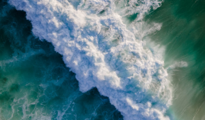
Tsunamis are giant waves caused by earthquakes or volcanic eruptions under the sea. Out in the depths of the ocean, tsunami waves do not dramatically increase in height. But as the waves travel towards land, they build up to higher and higher heights as the depth of the ocean decreases. The speed of tsunami waves depends on ocean depth rather than the distance from the source of the wave. Tsunami waves may travel as fast as jet planes over deep waters, only slowing down when reaching shallow waters. While tsunamis are often referred to as tidal waves, this name is discouraged by oceanographers because tides have little to do with these giant waves.
 A tsunami is a series of waves. The time between wave crests can vary from 5 minutes to an hour. The hazard may persist for many hours or longer after the initial wave. Impacts can vary significantly from one section of coast to the next due to local bathymetry and the shape and elevation of the shoreline. Impacts can also vary depending upon the state of the tide at the time of the maximum tsunami waves.
According to USGS, there has been no other seismic activity near Monday’s strong swarm zone for the 3 prior weeks.
The National Oceanic and Atmospheric Administration (NOAA) is the agency that monitors tsunamis around the U.S. through its Tsunami Program, which includes the National Weather Service (NWS) and its National Tsunami Warning Center in Palmer, Alaska and the Pacific Tsunami Warning Center in Honolulu, Hawaii. While the Pacific has more seismic activity than the Atlantic and therefore a greater chance at tsunami, they do occur in the Atlantic and Caribbean and the NWS centers are designed to cover those threat zones too. The National Tsunami Warning Center monitors the continental U.S., Alaska, and Canada. The Pacific Tsunami Warning Center monitors the Hawaiian Islands and U.S. Pacific and Caribbean territories
NOAA utilizes advanced observation systems, including its Deep-ocean Assessment and Reporting of Tsunamis (DART) buoys and seismic networks, to detect, warn, and forecast potential threats.
When Monday’s strong earthquake swarm began, the Tsunami Warning Center was quick to respond, issuing 7 bulletins for the Caribbean, Puerto Rico/USVI, Bahamas, U.S. Gulf of America coast, and the U.S. East Coast.
There was a magnitude 5.1 earthquake this morning at 7:05 am Pacific Time 7 miles off the coast of Oregon; this quake prompted the National Tsunami Warning Center to issue a bulletin.
For this morning’s bulletin and for the bulletins issued on Monday, they were merely informational alerts; no tsunami threat actually existed. But that could change in the future. And has been different in the past.
On February 8 this year, a Tsunami Advisory was issued for Puerto Rico and the Virgin Islands due a magnitude 7.6 earthquake east of Jamaica. The National Tsunami Warning Center (NWTC) initially said there was a tsunami threat to Puerto Rico and the Virgin Islands and that residents in those places were advised to move out of the water, off the beach and away from harbors, marinas, bays and inlets, and not go to shore to observe the tsunami. The center eventually canceled the advisory for Puerto Rico and the Virgin Islands, but said advisories were still in place for Cuba, Honduras, and the Cayman Islands, where waves above normal tide level were possible.
The recent earthquake activity this week is focused along and to the east of the Leeward Islands where the Caribbean Sea meets the Atlantic Ocean.
The Leeward Islands are located on the Caribbean Plate, at the boundary with the North American Plate. This is a region of complex tectonic interactions where the North American plate subducts beneath the overriding Caribbean plate, forming the Lesser Antilles island arc. The North American plate is subducting under the Caribbean plate to the east of the islands, causing the volcanic activity that formed the arc.
This area is also home to the Lesser Antilles Volcanic Arc. This geographic boundary runs from the Virgin Islands in the north to the islands to off the coast of Venezuela in the south. This boundary contains seventeen active volcanoes, most notably Soufriere Hills on Montserrat, Mount Pelée on Martinique, La Grande Soufrière on Guadeloupe, Soufrière Saint Vincent on Saint Vincent, and the submarine volcano “Kick ’em Jenny” which lies just north of Grenada.
A recent seismic swarm at the Kick ’em Jenny submarine volcano was in the news earlier this summer. Beginning in late August 2025, the area saw hundreds of tremors with magnitudes between 2.2 and 2.4. Although the activity has since decreased significantly, the volcano remains at an elevated yellow alert level and marine vessels are still required to stay away from the volcano.

Strong earthquakes in this region could develop tsunami that could spread throughout the Caribbean and the Atlantic Ocean; it’s possible tsunami could even enter the Gulf of America from a strong Caribbean quake.
To raise awareness of the risk of tsunami, and to have local first responders prepare and practice for potential tsunami, CARIBE WAVE happens each spring. CARIBE WAVE is an annual tsunami exercise of the Intergovernmental Coordination Group for the Tsunami and Adjacent Regions of the Oceanographic Commission (IOC) of the United Nations Educational, Scientific, and Cultural Organization (UNESCO). This year’s drill took place on March 20. The Pacific Tsunami Warning Center and the National Tsunami Warning Center drive the drill.
While the greatest risk is for communities with Pacific coastlines, tsunamis can strike any U.S. coastline including those around the Caribbean. Coastal areas such as beaches, bays, lagoons, harbors and river mouths and areas along rivers and streams that lead to the ocean are the most vulnerable. The safest place to be in a tsunami threat is 1 mile inland and/or 100 feet above sea level.
Tsunami messages and alerts are issued by the tsunami warning centers to notify emergency managers and other local officials, the public and other partners about the potential for a tsunami following a possible tsunami-generating event. For U.S. and Canadian coastlines, these messages include alerts. There are four levels of tsunami alerts: warning, advisory, watch and information statement:
- Tsunami Warning: Take Action—Danger! A tsunami that may cause widespread flooding is expected or occurring. Dangerous coastal flooding and powerful currents are possible and may continue for several hours or days after initial arrival. Follow instructions from local officials. Evacuation is recommended. Move to high ground or inland (away from the water).
- Tsunami Advisory: Take Action—A tsunami with potential for strong currents or waves dangerous to those in or very near the water is expected or occurring. There may be flooding of beach and harbor areas. Stay out of the water and away from beaches and waterways. Follow instructions from local officials.
- Tsunami Watch: Be Prepared—A distant earthquake has occurred. A tsunami is possible. Stay tuned for more information. Be prepared to take action if necessary.
- Tsunami Information Statement: Relax—An earthquake has occurred, but there is no threat or it was very far away and the threat has not been determined. In most cases, there is no threat of a destructive tsunami.
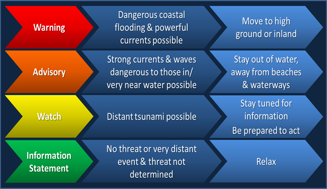
Tsunami warnings, advisories and watches may be updated or cancelled as information becomes available. Advisories, watches and information statements may be upgraded if the threat is determined to be greater than originally thought.
Tsunami has occurred along the U.S. East Coast in the past and will occur again in the future. Notable historic events include:
- 1929 Grand Banks earthquake: A magnitude 7.2 earthquake off Newfoundland caused a submarine landslide that generated a tsunami. The waves were strongest in Newfoundland but were recorded as far south as South Carolina.
- 1755 Lisbon earthquake: Although not a U.S. event, the earthquake off the coast of Portugal generated a tsunami that caused some waves to be observed on the East Coast.
- 1867 Virgin Islands tsunami: An earthquake in the Caribbean generated a tsunami with waves that were 12 meters high in the Virgin Islands. Waves also reached the U.S. East Coast.
- 2013 meteorological event: A tsunami-like wave was observed along the East Coast that coincided with a strong weather system, indicating a meteorological cause.
