Just in time tamper with Halloween decorations the day before the holiday, a potent storm is due to impact portions of New Jersey, Pennsylvania, Delaware, and New York with strong wind, heavy rain, and rough surf at the coast. Due to the threats, the National Weather Service has started to issue advisories for the region so that people are prepared for the storm.
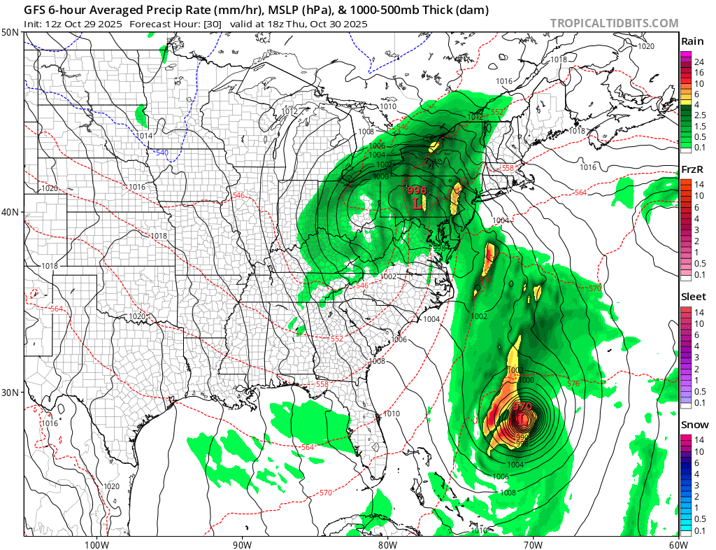
A variety of weather features on the map will work with each other to create conditions ripe for a storm to impact portions of the Mid Atlantic. While Hurricane Melissa moves across the Bahamas towards Bermuda, a weak area of low pressure off the Carolinas continues to meander, resulting in some very light showers along the coast and within inland areas of Delmarva and South Jersey. That weak area of low pressure will phase with a stronger low over the Tennessee River Valley, and push northeastward toward New Jersey tonight. While this will help push Melissa towards Bermuda and away from the U.S. East Coast, it’ll allow for a more widespread area of rain to overspread the region from southwest to northeast after midnight.
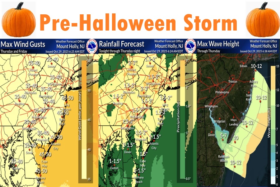
Rain will continue through midday, then gradually clear out from the southwest by the early afternoon to the northeast over the mid to late evening. The National Weather Service says flooding concerns are minimal given how dry this areas has been, but some of the forecast tools they use do show a small chance for 1″ per hour rainfall rates which could create isolated flood concerns. A vast majority of the area will receive just a beneficial rain, though if the heaviest rates end up over the urban corridor, there could be some flooding. When all is said and done, a widespread 1-3″ of rainfall is expected, with most falling over a 6 to 12 hour period.
In terms of the severe aspects with this system, the National Weather Service says that the “threat has ticked up a bit.” With such a strong wind field aloft , severe-level gusts could reach the surface. Additionally, strong low-level shear could result in a brief spin-up and an isolated tornado.
Given the current projected track of the low, the National Weather Service believes the severe wind/tornado risk is mainly for areas south
of I-195 and the Pennsylvania Turnpike.
Winds outside of thunderstorms will still be quite gusty, especially along the coast. A strong low-level jet will not be far off the surface, potentially resulting in some gusts of 40-50 mph. Beyond tampering with Halloween decorations, these winds could also knock down tree branches and wires, resulting in power outages. As a result, a Wind Advisory was issued for the New Jersey coastal counties of Monmouth, Ocean, Burlington, Atlantic, and Cape May County as well as the Delaware Beaches. The Wind Advisory goes through most of Thursday. Away from the coast, winds will still be breezy with gusts primarily in the 25-35 mph range, up to 40 mph.
The low pressure will move into northern New England by Friday morning before departing Friday night. Showers will taper off after midnight Thursday night, and then a tight pressure gradient between the departing low and high pressure building into the Northern and Central Plains develops over the area on Friday. This type of atmospheric set-up will yield west to northwest winds 20 to 25 mph with 35 to 40 mph gusts across much of the area, but gusts as high as 50 mph are possible for the Jersey Shore and Delaware Beaches. Winds will diminish Friday night as the pressure gradient relaxes.
Wave heights will be running to 10-12′ along much of the NJ shore, with lower amounts over Delaware Bay coastlines. There could be some minor to moderate coastal flooding at these locations but conditions should be much better than they were when the recent nor’easter moved through the region. Nevertheless, a Coastal Flood Advisory has been issued for Sussex, Delaware and Cape May, Atlantic, and Burlington counties in New Jersey and Queens, Suffolk, and Nassau counties in New York. A Coastal Flood Advisory is also in effect at the coast in southern Fairfield County in Connecticut and southern Westchester County in New York.
