Conditions remain dynamic on Hawaii’s Big Island at the Kilauea Volcano, where the threat of an imminent eruption seems to have passed for now. According to USGS and their Hawaiian Volcano Observatory (HVO) unit, a significant amount of magma has been intruded south and southwest of the summit caldera since Saturday, January 27. Since then, USGS believes about 40 million cubic yards or roughly 30 million cubic meters of molten rock has made its way into the region, below the surface.
“As long as this intrusion continues, there is a chance that an eruption could occur within or southwest of the caldera with little advanced warning,” HVO warns.
However, over the last 24 hours, earthquake and ground deformation rates around the Kilauea summit and to its southwest along the Koa’e fault system have decreased significantly. “The intrusion of magma into this area appears to have slowed, and the likelihood of an eruption has decreased.”
Because of the lower odds of an eruption today, HVO is lowering the Volcano Alert Level for ground-based hazards from WATCH to ADVISORY and the Aviation Color Code from ORANGE to YELLOW.
In the U.S., the USGS and volcano observatory units are responsible for issuing Aviation Codes and Volcanic Activity Alert Levels. Aviation Codes are green, yellow, orange, or red. When ground-based instrumentation is insufficient to establish that a volcano is at a typical background level of activity, it is simply “unassigned.” While green means typical activity associated with a non-eruptive state, yellow means a volcano is exhibiting signs of elevated unrest above known background levels. When a volcano exhibits heightened or escalating unrest with the increased potential of eruption, it jumps to orange. Finally, when an eruption is imminent with significant emission of volcanic ash expected in the atmosphere or an eruption is underway with significant emission of volcanic ash into the atmosphere, the code becomes red. Volcanic Activity Alert levels are normal, advisory, watch, or warning. As with aviation codes, if data is insufficient, it is simply labeled as “unassigned.” When the volcano is at typical background activity in a non-eruptive state, it is considered normal. If the volcano exhibits signs of elevated unrest above background level, an advisory is issued. If a volcano exhibits heightened or escalating unrest, a watch is issued while a warning is issued when a hazardous eruption is imminent.
It has been quite the week at the #Kilauea volcano with more than 3,000 earthquakes! A lot of magma is moving around! #HIwx https://t.co/lBGvY7lOVm
— the Weatherboy (@theWeatherboy) February 4, 2024
In total, more than 3,000 earthquakes were recorded over the past week during this event, which coincided with ground deformation patterns indicative of magma moving from beneath the summit to the southwest under the Koa‘e fault system. More information on this intrusive activity will be available in the Kīlauea daily update published later today.
Earthquake counts have dropped from 20-30 events per hour to 5-10 events per hour and earthquakes are no longer clustering in the vicinity of Pu‘ukoa‘e, but are dispersed more widely from the summit to the southwest. Depths remain consistent, less than a mile to 2.5 miles below the surface and magnitudes range a maximum of 3+ to less than 1. In total, less than 300 earthquakes have been recorded across this region over the past 24 hours, reflecting the continued decrease in seismicity.
Over the past day, tiltmeters near Sand Hill and Uēkahuna bluff have recorded very little change after the steep deflation of the past 2 days related to magma moving southwest.
According to HVO, Global Positioning System (GPS) instruments have recorded up to 8 inches of horizontal motion at stations around the Southwest Rift Zone and immediately to the south along the Koa‘e fault zone.
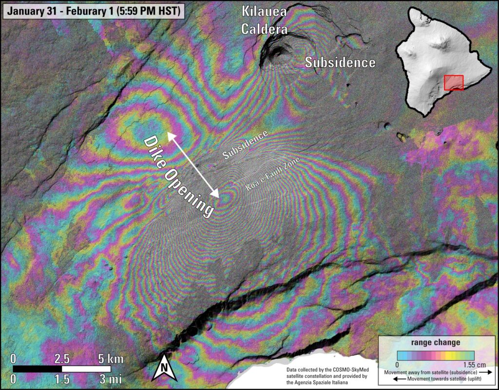
“Patterns of earthquakes and ground deformation indicate that magma intruded beneath the south end of the caldera beginning on the morning of January 27th. This activity waxed and waned until Wednesday, January 31, when greatly increased seismicity and tilt indicated a dike was being emplaced, triggering episodic felt earthquakes and rockfalls within Halema‘uma‘u,” said HVO in a statement today. “By 5 p.m. HST on January 31st, seismicity migrated southwest of the caldera towards the Ko‘ae fault system and tiltmeters in the south caldera area began to record strong deflation. Modeling of tiltmeter, GPS, and satellite radar interferometry (INSAR) images suggest that magma within the initial dike migrated southwest into the new intrusion as it opened beneath the Ko‘ae fault zone. The overall decrease in seismicity and deformation over the past 24 hours suggests that this event is waning. ”
But the update comes with a warning: “However, renewed episodes of activity remain a possibility and an eruption could occur with little advanced warning.”
