December 1 marks the arrival of the 2016-2017 Meteorological Winter Season. Meteorological winter is a three month period that runs through to the end of February. In the Northern Hemisphere, it is the coldest three month period of the year. Meteorological Winter is different from Astronomical Winter, which is based on when the sun reaches the most southern point on the globe, the Tropic of Capricorn. If you are right on the Tropic of Capricorn at 12 noon on the first day of Astronomical Winter, the sun will be directly overhead. This year, that date is Wednesday, December 21. While winter is starting in the Northern Hemisphere, summer begins in the Southern Hemisphere.

This year, it appears winter weather will arrive in sync with the winter season.
A strong storm system approaching Hawaii has triggered winter weather related advisories there. The National Weather Service office in Honolulu, Hawaii which is responsible for issuing advisories for the 50th state, issued Winter Storm Warnings for portions of the Big Island of Hawaii today. An upper level low moving over the Islands will lower freezing levels and destabilize the atmosphere while a surge of moisture moving in from the southeast will combine to produce bursts of heavy snow on the highest peaks of Hawaii. More than 6″ of snow and icy build-up on roads due to freezing fog are possible. The Warnings is up for Mauna Loa and Mauna Kea above 8,000 feet elevations; the heaviest snow is expected at elevations over 12,000 feet. The Winter Storm Warning there runs through 6pm local time Friday.

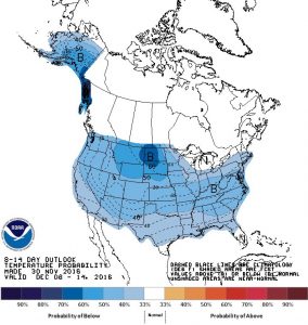
Meanwhile in the rest of the United States, a significant below-below normal cold blast will impact the country. For the first time since March 20, 2013, the National Weather Service’s Climate Prediction Center 8-14 day outlook shows much of Alaska and the Lower 48 covered in blue to illustrate below to much below normal temperatures expected over the forecast period. The last time the lower 48’s forecast from the Climate Prediction Center looked like this was December 21, 2013. These maps are in alignment with computer forecast model data that shows a significant cool-down impacting the United States next week and lingering into the middle of the month. Extended forecast guidance also suggests the cold air will linger into the balance of the month. While this could be bad news for travelers and their holiday plans this month, it could be good news for snow lovers and ski resorts that need cold and snow to support holiday tourists.
As shared in our official 2016-2017 Winter Weather Outlook here, a colder and snowier winter is expected for the northeastern quarter of the continental United States when the entire winter is seen in aggregate.