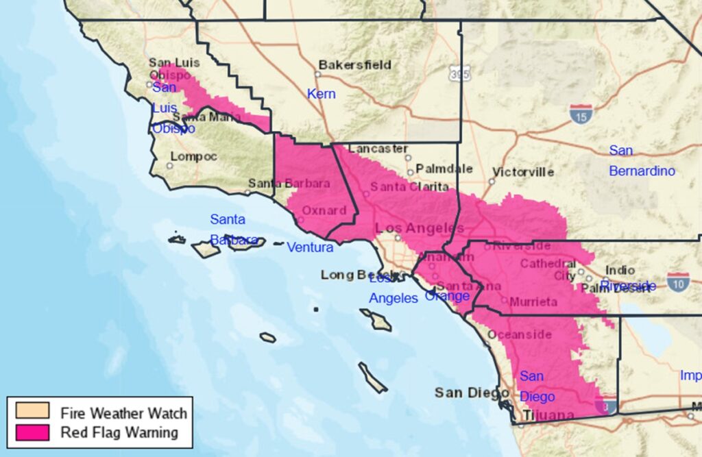
The National Weather Service has issued Red Flag Warnings for extreme fire danger in southern California including the hills surrounding Los Angeles; they’ve actually elevated their concern, by labeling this fire weather threat a “Particularly Dangerous Situation” or PDS for short. A strong and damaging Santa Ana wind event will develop across portions of Los Angeles and Ventura Counties tonight into Tuesday with decreasing winds Wednesday. Extremely critical fire weather
conditions will develop as a result of this weather situation.
The National Weather Service says a major Santa Ana wind event will start this afternoon, peak early Tuesday morning, and then persist into Wednesday. The majority of Ventura and Los Angeles counties are now under high wind warnings and wind advisories. According to the National Weather Service, the main wind corridor will stretch from the mountains northeast of the Santa Clarita Valley to the eastern valleys of Ventura county and then down through the southern coastal section of Ventura county. The Calabasas, western Santa Monicas and Malibu areas will also be greatly affected by these winds.
Wind gusts will reach damaging levels, knocking down trees and power lines and blowing items such as holiday directions away if they’re not properly secured. According to the National Weather Service, peak wind gusts in the mountains could reach 80 mph while coastal and valley locations could see wind gusts as high as 70 mph.

According to the National Weather Service, “fire weather” is the use of meteorological parameters such as relative humidity, wind speed and direction, mixing heights, and soil moisture to determine whether conditions are favorable for fire growth and smoke dispersion. Based on the analysis by meteorologists at the Los Angeles office of the National Weather Service, a Fire Weather Watch, indicating the possibility of fire weather risks, have been issued for for large parts of the area. The combination of dry fuels, low relative humidity values, and high winds will result in very high fire danger across southern California.
“Any fires that start will likely spread rapidly and be very difficult to control. Outdoor burning should be avoided altogether until these critical conditions end,” the National Weather Service warned.
With the strong likelihood of widespread single digit humidities with this event, there is high confidence for a long duration Red Flag event. In addition, there is high confidence of “PDS” Red Flag Warning conditions late this evening through Tuesday, as damaging wind gusts of 60 to 80 mph will likely overlap with single digit humidities across many of the windier mountain and foothill areas, and with gusts of 40 to 65 mph across most wind prone coastal and valley areas of Los Angeles and Ventura counties. With the threat of damaging wind gusts in these windier corridors, there will be an increased risk for downed trees and powerlines, along with power outages. The hardest hit areas will likely be the San Gabriels, Santa Susanas, western Santa Monicas into Malibu, Ventura county valleys, especially Simi Valley and Moorpark, western San Fernando Valley, especially Highway 118/210 corridors from Porter Ranch to San Fernando, and the hills above Camarillo into east Ventura.
Due to the expected long duration of dangerous fire weather conditions and critically dry fuels, there is an increased risk for any new ignitions to have very rapid fire spread and extreme fire behavior including long range spotting. As a result, there is the increasing threat for fire weather conditions to rival other historical fires in recent times including the Mountain and Thomas Fires. Dry offshore conditions will likely persist into Thursday morning, with
a return of onshore flow and some humidity recovery in the afternoon.
