• Skip to primary navigation
  • Skip to main content
  • Skip to primary sidebar

Weatherboy

Weatherboy Weather News, Maps, RADAR, Satellite, and Forecasts.

  • Local
  • Earth Science News
  • RADAR
  • Current Warnings
  • Satellite
  • Current Maps
  • Forecast Maps
  • Video

Excessive Heat Likely in East Next Week

by Weatherboy Team Meteorologist - June 11, 2024

There are two possible excessive heat zones possible next week where record-breaking high temperatures are possible. Image: NWS CPC


The National Weather Service’s Climate Prediction Center (CPC) is warning that in addition to summertime heat, some excessive heat is possible in portions of the eastern U.S. next week, with record breaking high temperatures possible too.

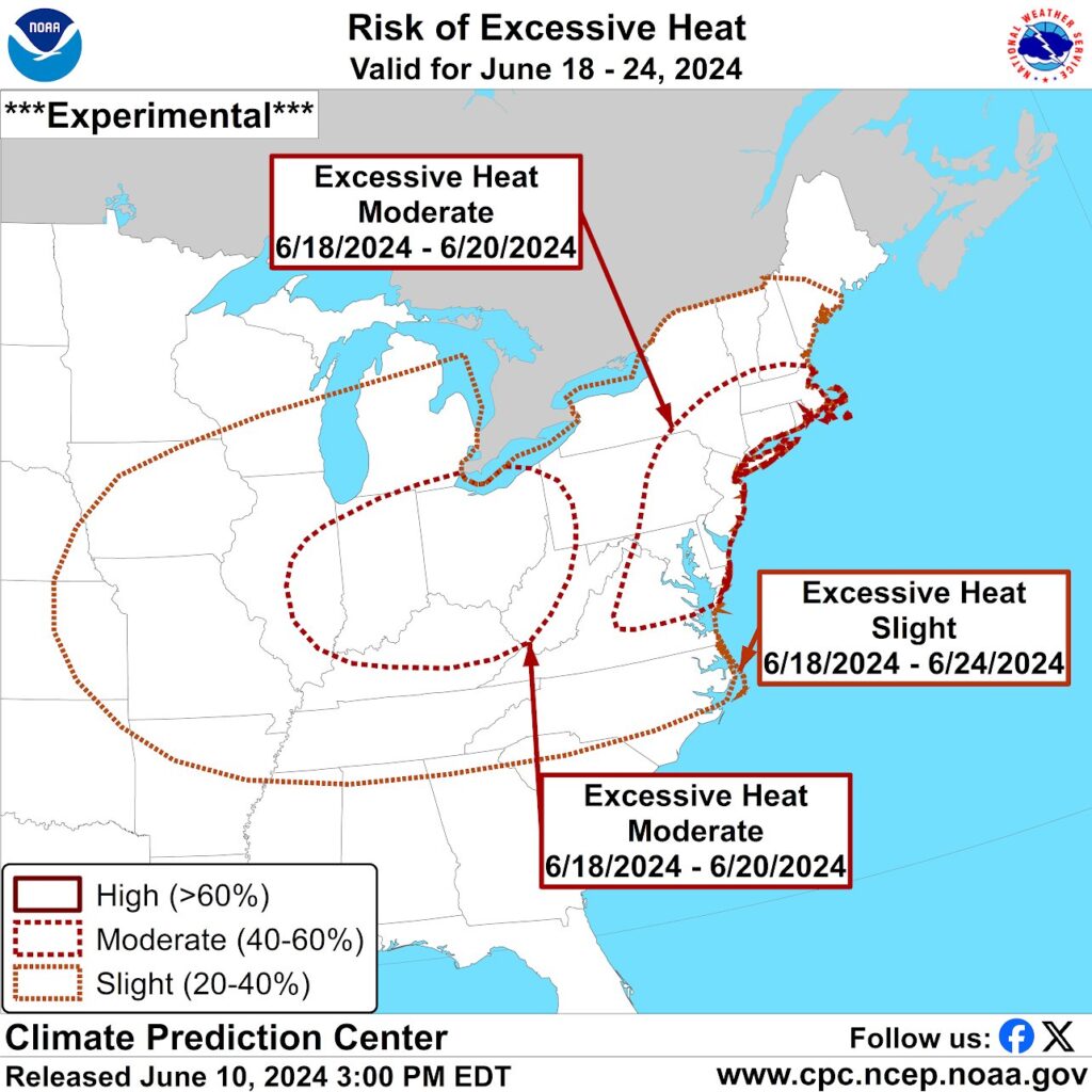
According to the CPC, there is at least a slight chance of excessive heat in an area stretching from Missouri to New Jersey, north to Michigan and southern Maine, and south to Tennessee and North Carolina between June 18 and June 24.

However, there is a higher, moderate risk of excessive heat over Ohio, Indiana, and northern Kentucky as well as New Jersey, Delaware, much of Maryland, northeastern Virginia, southeastern New York, and all of Rhode Island, Connecticut, and Massachusetts over the June 18-20 period.  This means there’s at least a 40-60% chance of excessive heat in those areas those days.

For the week of June 16-20, temperatures will likely be running above normal for much of the eastern U.S.. Image: NWS CPC


According to the CPC, computer models are in good agreement that  an amplified longwave pattern with a trough over the western contiguous U.S. (CONUS) and a broad ridge centered across the Midwest and Mid-Atlantic will help warm things in the East. While this weather pattern  favors below-normal temperatures across the Pacific Northwest, northern Rockies, Great Basin, and northern California, strong ridging and its associated positive height anomalies will increase above-normal temperature probabilities throughout the eastern and central CONUS. With  anomalous mid-level ridging, temperatures may climb more than 10 degrees above normal across portions of the east.

Primary Sidebar

Sponsored Ad

Search

Latest News

  • Forecasters Update Atlantic Hurricane Season Outlook
  • Earthquake Rattles Eastern Tennessee
  • More Mid Atlantic Flash Flooding Likely Today
  • Severe Storm and Flash Flood Threats Persist in Mid Atlantic
  • Chantal’s Remnants Push Flood Threat to New Jersey and Pennsylvania
  • Death Toll Rises as Major Federal Disaster Declaration Signed
  • Tropical Chantal Moves Inland, Soaking Mid Atlantic
  • Tropical Storm Warnings Issued as Chantal Approaches East Coast
About | Careers | Contact | Contests
Terms | Privacy | Ad Choices
Weatherboy is a (R) Registered Trademark of isarithm LLC, All Rights Reserved.
All content herein is Copyright by Isarithm LLC 1997-2022