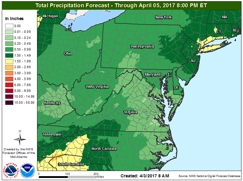
April is beginning on a wet month for many, bringing along a flood threat too, as heavy showers spread in regions that need the rain. While an unusually dry winter season has led to drought conditions in parts of the US southeast and northeast, the same can’t be said for the newly started spring season that’s bringing soaking rains to the same area.
The National Weather Service has issued Flood Watches for portions of New Jersey and New York for heavy rain expected there late Monday night through to Tuesday evening. Rain is forecast to overspread northern and central New Jersey late Monday evening. The rain is expected to become moderate to heavy from Monday night into early Tuesday morning. Rainfall rates should diminish during the mid to late morning hours on Tuesday. However, there is a chance of scattered showers and thunderstorms Tuesday afternoon that could bring additional locally heavy rainfall. All precipitation should end by Tuesday evening in this region. Rainfall totals of 1 to 2 inches are expected with locally higher amounts possible. The moderate to heavy rain is forecast to fall on areas that received generally 1 to 3 inches of rain on Friday; because the ground remains wet, and rivers
and streams continue to run high, that area is subject to an increased flood threat.
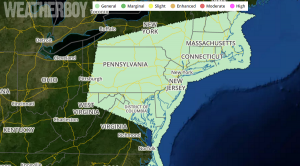
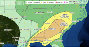
Meanwhile, a potent weather system in the southern US will bring heavy rain and the threat of severe weather further east. A mid-level trough moving over Louisiana Monday morning will eject east-northeastward to the Ohio Valley and southern Appalachians by
Monday evening, and continue to the Mid-Atlantic coast on Tuesday. An associated surface cyclone will likewise develop northeastward from Missouri to southeast Lower Michigan by Tuesday morning. The cold front trailing southward from the Missouri cyclone is somewhat ill-defined as a result of widespread pre-frontal convection that now extends from central Alabama to extreme southeast Mississippi. This band of convection will likely persist through the day while
moving eastward across Alabama/Georgia and the Florida Panhandle, where the convection will be maintained by an influx of mid 60s to low 70s boundary layer dewpoints from the northeast Gulf of Mexico. Low-midlevel flow/shear will remain fairly strong but largely
line-parallel across southeast Alabama, southwest Georgia, and the Florida Panhandle, which will support occasional damaging gusts and some embedded tornadoes in the line. Severe weather will enter the southeast along with heavy rain; upwards of 2″+ could fall over southwestern North Carolina, northwestern South Carolina, and northeastern Georgia.
Turn around, don’t drown! Never drive through flooded roadways.
