A major winter storm is likely to impact portions of the eastern United States this coming weekend, bringing more than a foot of snow to portions of the Mid Atlantic. The eastern U.S. has had an early start to the winter snow season, with storms in November ahead of the December 1 start day of meteorological winter. This next storm is likely to bring heavy snowfall more south than earlier storms, creating travel headaches for many Sunday night into Monday. While confidence in this storm is high among meteorologists, there is still some question and doubt with how far north the system will move. However, confidence is rather moderate that this storm won’t move as far north as once thought.
How this storm evolves and moves into the Mid Atlantic will be dependent on what happens with two streams of air moving over North America: a Pacific stream and a Polar stream. If conditions were just perfect, the influence of these two streams can lead to a historic east coast snow storm, as is the case sometimes over some winters. However, it is extremely unlikely that such a storm situation will unfold this weekend due to a variety of factors. Rather than a historic East Coast storm, meteorologists have been tracking three possible scenarios. The first would be if the Polar stream is moving too slow while the Pacific stream is moving too fast, a scenario suggested by most forecast models in recent runs. If this were to happen, while a winter storm would blossom over the interior southeast, it would continue east without hooking up the coast, bringing snow to the southern and central Mid Atlantic but not much of anything else further north. The second possible scenario would be if both the Polar stream and Pacific streams are moving fast. This would yield a solution similar to the first, with a storm being sped off to the ocean. If it moved quickly enough, precipitation would be light to moderate across the central and southern Mid Atlantic. The third scenario would be if the Polar stream sped up while the Pacific stream slows down; this would allow the storm system to hook up the coast, bringing snow to the north Mid Atlantic and southeastern New England. If the storm moved up the coast quickly or pushed inland of the coastline, it could even warm up the coastal plain and produce plain rain there. The major global weather forecast models continue to suggest any of these three possibilities.
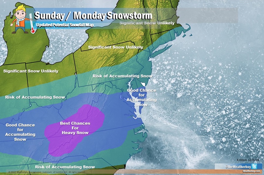
Based on data we’ve seen and climatological analysis for systems like this one at this time of year, it is most likely that the first scenario is the one that’ll occur. Later this weekend, snow would move into portions of the southern Mid Atlantic, with a heavy pocket of snow likely well inland in the higher terrain around the Appalachian Mountains. The best chance for heavy snow is over West Virginia, western Virginia, northwestern North Carolina, and northeastern Tennessee. Such a scenario would also bring accumulating snow in northern portions of West Virginia, Maryland, eastern Maryland, and extreme southern Delaware; it could also produce snow rather south, in northern Georgia and South Carolina.
There is still a risk the system may come up the coast a little bit before departing the coast. If this were to happen, accumulating snow could be seen in southern Pennsylvania, most of New Jersey, the New York City metro area, Long Island, and extreme southern New England. Within the next 12-24 hours, meteorologists should have a better idea of whether or not such a northern extent is possible. Beyond this region, across northern Pennsylvania, northwestern New Jersey, much of Upstate New York, northern Connecticut, and points north, no significant snow is expected anymore, even if the storm does take a slight jog to the north. To produce snow in New England, the storm would need to push north into the northeast and there does not appear to be any atmospheric dynamics at play to make such a move.
It is likely that the first snowfall forecast maps for this system will be released by Thursday afternoon for this storm, with possible advisories being issued by the National Weather Service as soon as late Friday ahead of this weekend system.
