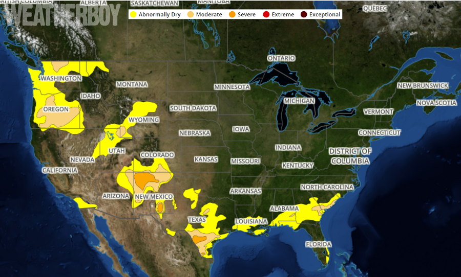
With an active weather pattern across much of the country, the latest Drought Monitor map shows America is moist. The Drought Monitor, issued each week by the U.S. Department of Agriculture, shows that there are no “Extreme” or “Exceptional” drought areas anywhere in the country. The U.S. Drought Monitor is a map released every Thursday, showing parts of the U.S. that are in drought. The map uses five classifications: abnormally dry, showing areas that may be going into or are coming out of drought, and four levels of drought: moderate, severe , extreme , and exceptional.
The Drought Monitor has been a team effort since its inception in 1999, produced jointly by the National Drought Mitigation Center (NDMC) at the University of Nebraska-Lincoln, the National Oceanic and Atmospheric Administration (NOAA), and the U.S. Department of Agriculture (USDA).
Drought is a normal part of the climate cycle. It is a slow-moving hazard, which causes people to underestimate the damage it can do, but losses from drought are as substantial as those from hurricanes, tornadoes and other faster-moving disasters. Drought causes losses to agriculture; affects domestic water supply, energy production, public health, and wildlife; and contributes to wildfire, to name a few of its effects.
No single federal agency is in charge of water or drought policy; response and mitigation fall to an assortment of federal authorities. The USDA leads response efforts; NOAA, through the National Integrated Drought Information System , leads monitoring; agencies such as the U.S. Geological Survey and NASA contribute data; and the Environmental Protection Agency regulates water quality. The National Drought Resilience Partnership, launched in the aftermath of widespread drought in 2012, is an effort to unify federal drought response and policy. Drought response efforts, planning, and water law vary from state to state.
Areas like California that saw extreme droughts just years ago have recovered, with normal to above-normal rain and snow fall restoring moisture levels to where they usually are.
Elsewhere in the country, there are patches of drought. Currently, these moderate areas of drought cover portions of northwestern New Mexico and southwestern Texas. Overall, though, there’s very limited dry areas over the United States now, as the latest U.S. Drought Monitor Map shows.
