Another round of snow is likely in the Northeast on Monday and Tuesday in what seems like an endless supply of snow events that brings several inches of snow to the region every few days. February is generally a snowy month in the winter in this region and February 2021 won’t disappoint snow lovers here again.
After a fair weather weekend, a mid-level shortwave will continue to deamplify Monday as it tracks across the northern Plains into the Ohio Valley. This disturbance will drive a surface low across the Great Lakes into Ontario, Canada and New England through Monday afternoon, bringing a quick round of snow to the region. With limited cold air and moisture to work with, snow will remain more light than heavy, with most falling well north and west of the I-95 corridor. Along the I-95 corridor itself, there could be a rain/snow mix at times, but significant icing problems aren’t expected with this system. The upper level atmospheric weather pattern doesn’t support a big storm nor does it support a slow system to stall-out; as such, this will be a quick-hitter with drier weather returning Tuesday.
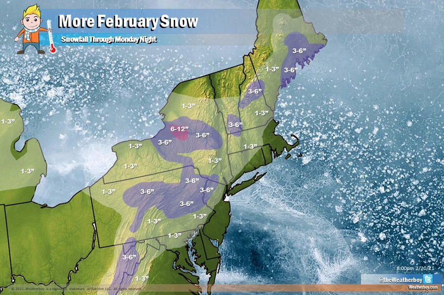
A wide area of 1-3″ snowfall is expected across much of Pennsylvania, western Virginia, eastern West Virginia, central and western Maryland, northwestern New Jersey, Upstate New York, northwestern Connecticut, central and western Massachusetts, southern Vermont and New Hampshire, and much of central Maine. Slightly heavier amounts of 3-4″ with isolated amounts to 6″ are possible in the higher terrain of West Virginia, central and northeastern Pennsylvania, northwestern New Jersey, central Upstate New York, southern Vermont, central New Hampshire, and central coastal areas of Maine.
A heavier band of snow is possible over the central part of Upstate New York east of Syracuse where the Lake Effect could amp up snowfall amounts to 6-12″. Outside of this lake enhanced snow area, snow should be generally light from this system.
While most precipitation will wrap-up late Monday night, a weak secondary cold front is forecast to move southward out of the Great Lakes into our the Mid Atlantic on Tuesday. This frontal passage could trigger isolated snow squalls, especially over Pennsylvania, New Jersey, and New York.
