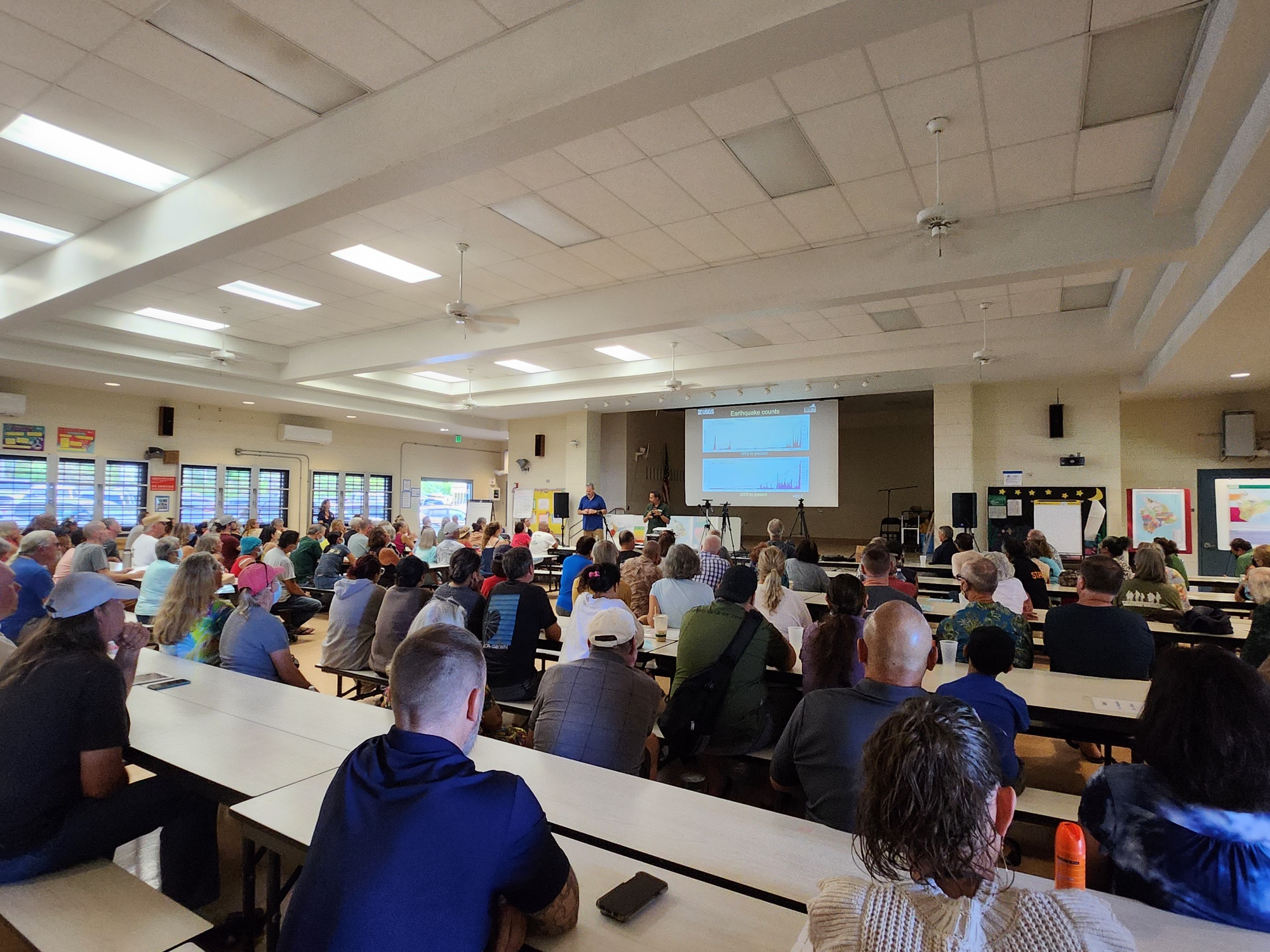
Officials with Hawaii County Civil Defense (CD) and USGS’s Hawaiian Volcano Observatory (HVO) hosted another townhall-style meeting this weekend on the Big Island of Hawaii as Mauna Loa, the world’s largest active volcano, shakes and quakes itself into a period of heightened unrest. The meeting, the third in a series of meetings being held around the island, are to provide complete transparency into what officials know and don’t know about the inevitable future eruption of the giant volcano. In recent weeks, seismic activity and expansion of the volcano have been on the upswing; in just the last few months, Mauna Loa grew by 6 cm as magma entering into it is swelling it. In the last 6 days, there have been more than 40 earthquakes at the volcano, which is more than double the usual volume at Mauna Loa.
Mauna Loa is considered the largest active volcano on Earth, rising to 13,681 feet above sea level. Mauna Loa rises up from the ocean floor of the Central Pacific at a depth of about 3 miles. Because of the volcano’s significant mass, the ocean floor directly beneath Mauna Loa is depressed by another 5 miles. According to USGS, this places Mauna Loa’s summit about 56,000 feet above its base; the enormous volcano covers half of the island of Hawaii, also known simply as the “Big Island of Hawaii.”
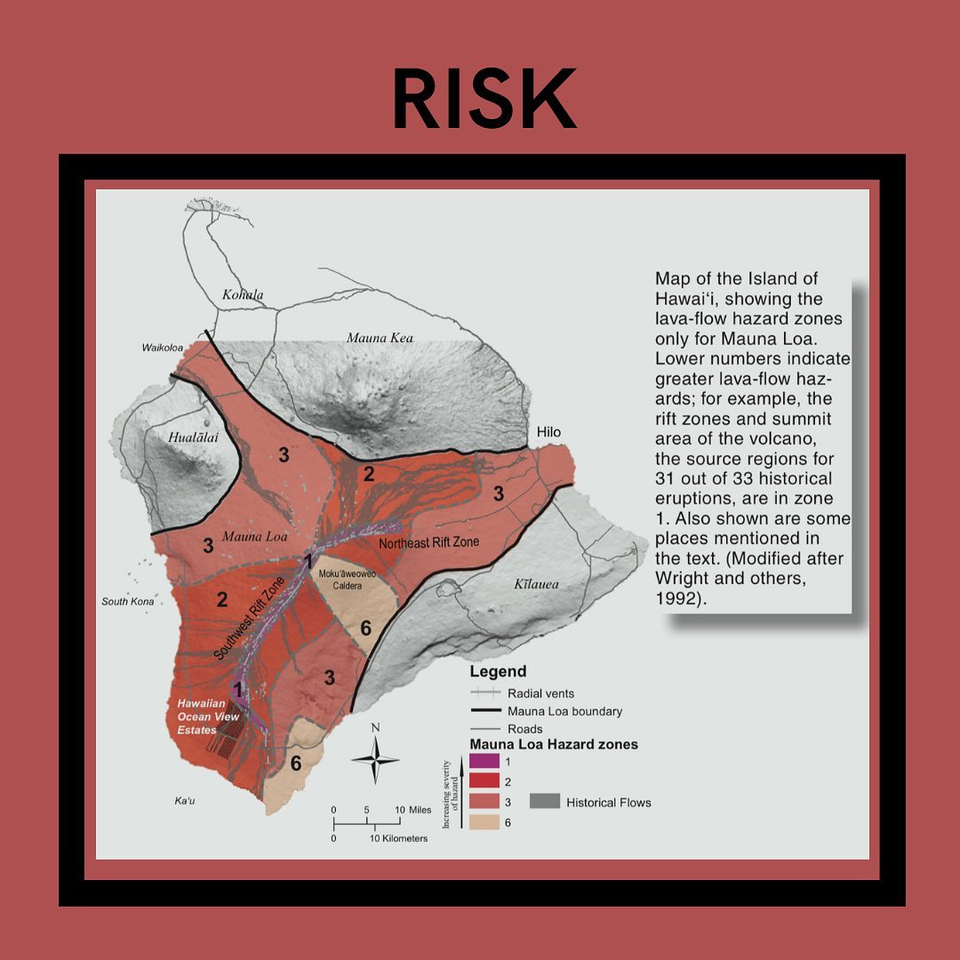
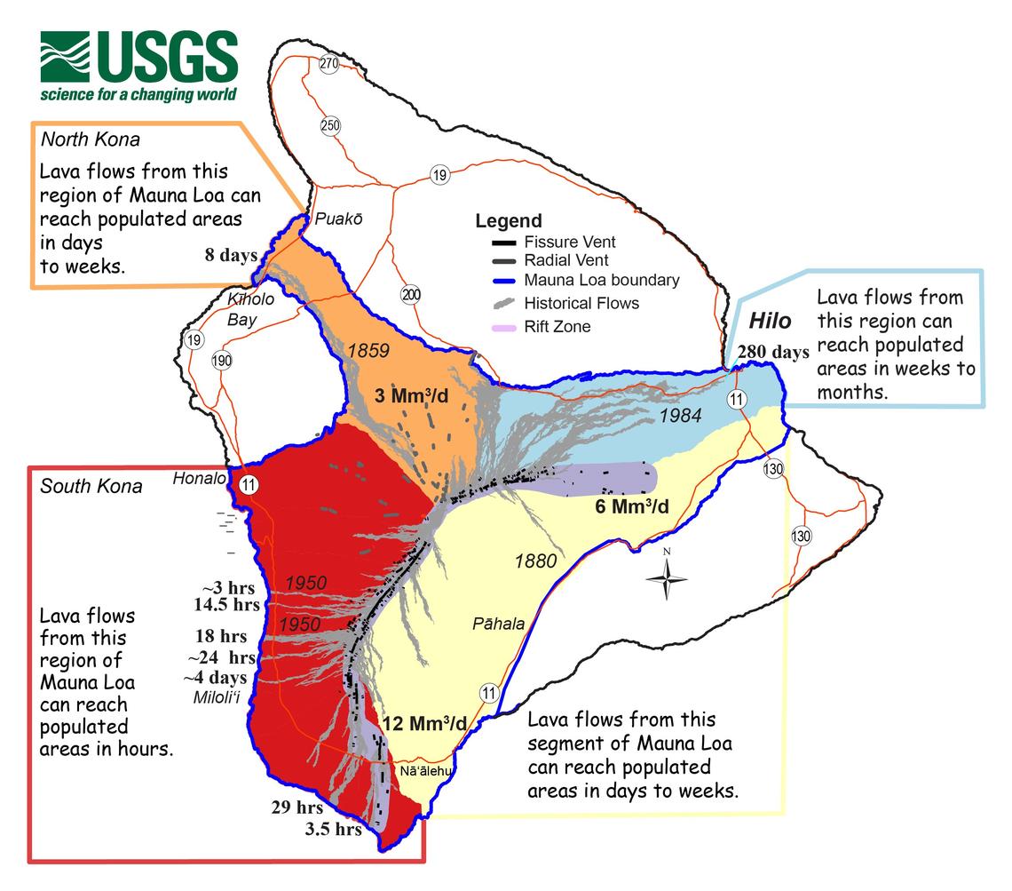
Mauna Loa eruptions tend to produce voluminous, fast-moving lava flows that can impact communities on the east and west sides of the Big Island from Kona to Hilo. Since the 1850s, Hilo in eastern Hawaii has been threatened by 7 Mauna Loa lava flows. On the south and west sides of the island, Mauna Loa lava flows have reached the coast there 8 times: in 1859, 1868, 1887, 1926, 1919, and three times in 1950.
The last eruption was in 1984 when the population of the Big Island of Hawaii was only 103,528; the population has nearly doubled to more than 200,000, with many of those living in the possible path of lava from the massive volcano. Due to that, there is growing concern by scientists, safety officials, and local residents to have a firm understanding of what’s what.
While an eruption at the giant volcano is inevitable, it isn’t imminent. USGS scientists Ken Hon, who serves as the Scientist-in-Charge for HVO, and Research Geologist Frank Trusdell, stressed to attendees of the meeting that an eruption won’t happen immediately. But they also admitted they don’t know when exactly it will erupt. “Mauna Loa continues to be in a state of heightened unrest as indicated by increased earthquake activity and inflation of the summit. The current unrest is most likely being driven by renewed input of magma 2–5 miles beneath Mauna Loa’s summit” both scientists mentioned in their presentations.
Despite the uncertainty, residents who packed into the Konawaena Elementary School in Kealakekua, the southern part of the Kona District, were eager to get any information and insight they could. After a thorough presentation by USGS and CD, residents lined up to ask questions about evacuation routes, potential traffic snarls during evacuations, and what to do about school children should an eruption occur during a school day.
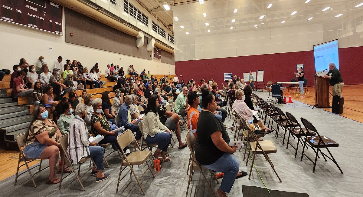
Residents packed in other venues in recent weeks in Pahala and Ocean View too, two communities on the island that could see the first impacts of earthquakes, tsunami, and lava flows on the island when Mauna Loa erupts. At the other venues, similar questions were raised, with officials on-hand to provide their best, informed answers.
The theme across each meeting is the same: now is the time to get prepared.
Hawaii County Civil Defense Administrator Talmadge Magno told residents this weekend to be prepared for an eruption. “This volcano is not dead. Now’s the time to prepare in case an eruption occurs…It could be only hours before lava inundated this area. So now is the time to get ready.”
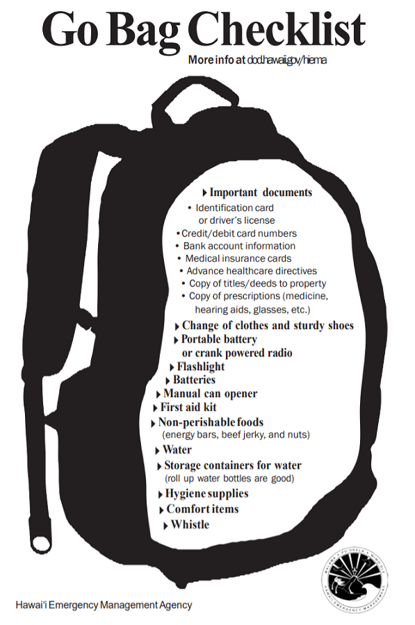
Magno said now is the time to revisit personal eruption plans. Similar to preparing for hurricane season, having an eruption plan in advance helps during an emergency.” Hawaii County Civil Defense and the Hawaii Emergency Management Agency are urging people in the possible paths of Mauna Loa’s lava to develop a plan and pack a “go bag.”
“We work with partners like the HVO for volcano and earthquakes and NOAA for tsunamis and hurricanes,” Magno said. “During the blue skies period when there isn’t an active disaster, we work with partners preparing for emergencies. But now that we’re in an advisory, we now engage with scientists and the public and put together our plans and outreach to the community.”
“We need the community to receive our messages,” Magno said, encouraging that locals sign-up for Everbridge TXT, email, and phone alerts should things change. Users can customize the types of alerts they get, ranging from flood advisories to earthquake, tsunami, and volcano updates, when they’re issued.
Magno wants people prepared if they need to evacuate their homes in case lava heads their way. “Do you have friends or family you can stay with? Do you have the ability to stay in a hotel? Or leave the island? Shelters will be open for people who have no other places to go, and they will be pet friendly.”
Magno also warned that when an eruption occurs, cell phone networks will likely be overwhelmed with activity, leaving many people with dropped calls or simply no service. “If you aren’t in harm’s way, stay off cell phones. Texting is best.”
Since earlier this month, USGS has been providing daily updates to the public on activity at the volcano. The activity remains heightened and scientists aren’t sure if it’ll continue to increase or decrease. Either way, officials urge caution, calmness, and plenty of preparation for “just in case.”
This period of heightened unrest began in mid-September 2022 when earthquake rates below Mauna Loa’s summit grew from 10-20 per day to 40-50 per day. In addition to the dramatic increase of earthquakes, there’s also been an increased rate of inflation recorded by GPS stations and by a device near the volcano summit.
“The unrest is likely caused by renewed input of magma into Mauna Loa’s summit reservoir system. As the reservoir expands it is triggering small earthquakes directly beneath Mokuʻāweoweo caldera and in a region just to the northwest of the caldera,” HVO said in today’s update. “Deeper magma input is detected by the continued increase in upward movement and extension measured between GPS stations located on the ground surface. Shallower magma input was likely responsible for inflation recorded on the summit tiltmeter during the last two weeks of September. The current locations of earthquakes and deformation do not necessarily mean that the next eruption will occur there.”
In previous eruption events at Mauna Loa, earthquake activity significantly increased. However, as Hon and Trusdell took great time and detail in describing at the last two community meetings, the seismic signature from previous events have all been unique and the current uptick in activity isn’t an exact match to past eruption events nor are there any clues to when or where an eruption will occur, if one does occur anytime soon.
“The current increase in activity does not suggest that a progression to an eruption is certain, and there are no indications that an eruption is imminent,” USGS was clear to communicate not only in their in-person meetings, but in ongoing daily updates they release too.
However, when an eruption does occur, residents may only have a very short time to act.
“Right now, we are at a Yellow/Advisory alert level,” Hon said. “There is heightened unrest, we know magma is coming, and there’s earthquakes and deformation of the volcano.”
Hon said based on previous eruptions with Mauna Loa, it is likely lava will begin erupting at the summit. In as little as an hour or two from there, lava could break out somewhere on a rift zone high on the volcano and pour volumes of lava down its slopes.
“We will go to an Orange / Watch alert level when we believe a summit eruption is imminent,” Hon said, adding that at that moment, people should be ready to get out of harm’s way. “And once the summit eruption occurs, we will go to a Red / Warning” level,” Hon added.
Once the lava moves, Hon said HVO will issue a warning to a specific area or areas where lava could threaten people. Until the eruption occurs, lava could flow out in many directions around Hawaii’s Big Island. Once lava advances towards a specific area, USGS will issue more detailed, specific warning areas that are in imminent danger of lava inundation.
Unfortunately, things could happen quickly; Hon warns the whole process of evolving from the current Yellow / Advisory level to a Red/Warning eruption period could be as little as 1, 2, 3, or 4 hours.
Civil Defense also can’t do much until lava reaches the surface other than prepare people on the Big Island for Hawaii for Mauna Loa’s inevitable return to action. Magno said his agency is talking to residents now because communities closest to potential lava paths wouldn’t have enough time to learn how to respond and prepare once the observatory raises its alert level to Orange / Watch.
Once lava is flowing, USGS/HVO and CD will coordinate to determine who should evacuate and where/when. Other agencies will become involved if there’s other threats from eruption-related earthquakes, tsunamis, toxic gas clouds, or volcanic fall-out, each which bring their own challenges and hazards.
The biggest challenge now is that scientists don’t know how an eruption will unfold if it actually unfolds soon. While earthquake sequences like the current one have led to a summit eruption, there have been other seismic event periods that passed without any eruption. An eruption at Mauna Loa always starts at the summit; from there, it could continue on its slopes through fissures that open up on rift zones, or through radial vents that extend out on the western slopes of the volcano. But not every summit eruption leads to lava flows below the summit.
“Since 1832, there have been 33 eruptions. About half stayed in the caldera (at the summit), while 25% erupted into northeast rift zones towards Hilo and 20% erupted into southwest rift zones towards Ocean View,” said Trusdell. “And we’ve had radial vents on the north and west flanks too.”
Where the lava heads on the island and the speed it takes to get there is a function of the dramatically different terrain on the volcanic Hawaiian island.
“In Hilo, you have weeks to months to prepare,” Trusdell said, describing how a flow heading into the heavily populated northeastern corner of the island would take a considerable amount of time to get to due to the slope of the terrain. “It will take days to weeks for a flow to threaten South Kohala,” added Trusdell, pointing out that Hawaii’s famous gold coast dotted by luxury resorts like Auberge’s Mauna Lani, Hilton’s Waikoloa Village, and the Fairmont Orchid could be in the path of a future lava flow. The resorts are built on flows that erupted from Mauna Loa in the 1850’s.
But for people that attended these community meetings, there may only be hours advance notice. Which is why the community meetings are held in these specific communities.
Magno says his office is working on a fourth community meeting, although the timing and specific location isn’t yet published. A source from the Hawaii County Mayor’s Office said it will likely be in Milolii, a coastal village 33 miles south of Kailua-Kona built on a 1926 lava flow from Mauna Loa.
We asked if Waikoloa Beach, Waikoloa Village, or the South Kohala coast would be home to one of these community meetings, but Magno said no. “We’re trying to hit the folks where there’s a life – safety concern,” Magno said. According to USGS, while lava flows could threaten South Kohala, it would take multiple days of active lava flows heading in their direction to get there, giving residents plenty of time to move out of harm’s way …unlike those in South Kona and towns in Ka’u District.
While a community meeting isn’t on the books for South Kohala or Hilo, CD and USGS both warn it’s possible lava could ultimately make its way there in a future eruption. As such, they advise people to prepare for a volcanic eruption and the hazards it brings –even if people may not be in the immediate path of an advancing lava flow.
Well before the lava becomes visible is the best time to prepare for the disaster. USGS scientists said waiting until the eruption event to unfold to prepare may be too late.
“If you see the glow, it may be time to go,” added Trusdell. When an eruption occurs at the summit, a glow may be visible from atop Mauna Loa across large parts of the island. Beyond advisory messages from CD and USGS, that could be sign it’s time to take action and put plans developed now into motion.
