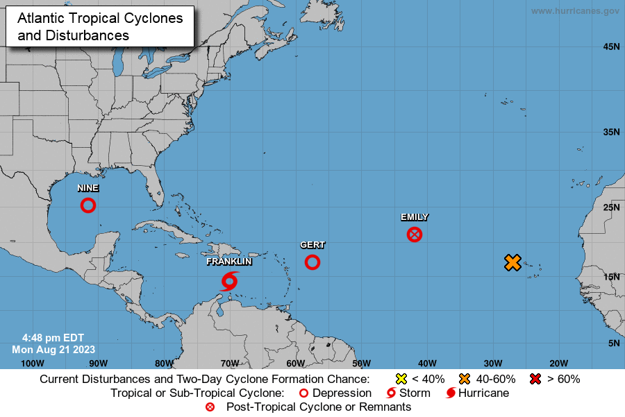
The Atlantic Hurricane Basin has exploded with activity from tropical cyclones over the last 24 hours, with three named storms and the potential for two more on the way. Emily, Gert, and Franklin have all developed although Franklin is the only storm of consequence for now that is forecast to become a hurricane with time. Tropical Depression #9 has developed in the Gulf of Mexico and could become a stronger tropical cyclone before it hits Texas while an area near the Azores also has a high probability of becoming a tropical cyclone soon.
The first of the bunch is Emily and is likely the first to disappear too. Emily is now a remnant low and the National Hurricane Center (NHC) issued its last advisory on it this morning. Located about 1,225 miles west-northwest of the Cabo Verde Islands, the system is expected to dissipate completely in the Atlantic today.
Tropical Storm Franklin is meandering to the south of Hispaniola; heavy rain is expected over the Dominican Republic and Haiti beginning tomorrow. Now located about 290 miles south of Santo Domingo in the Dominican Republic, the storm has maximum sustained winds of 50 mph as it heads to the west very slowly at 5 mph. According to the NHC, A sharp turn to the north is expected on Tuesday with this general motion continuing into Wednesday. On the forecast track, the center of Franklin is forecast to reach the southern coast of Hispaniola by early on Wednesday. The storm is also forecast to strengthen before it gets there, prompting Tropical Storm Warnings to be issued already for the area.
The next storm to form in the Atlantic was Gert and like Emily, is it expected to dissipate soon. Located about 375 miles east of the Leeward Islands, this disturbance, according to the NHC, “could dissipate or become post tropical at any times” while it wanders about in the Atlantic.

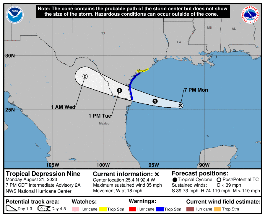
Tropical Depression #9 formed in the Gulf of Mexico. Located about 375 miles east-southeast of Port Mansfield, Texas, the system has maximum sustained winds of 35 mph while it moves to the west at 18 mph. The NHC expects the storm to become a tropical storm before it arrives on the Texas coast. When and if that happens, it’ll be named Harold. Due to the likelihood of it happening, the NHC has already issues Tropical Storm Warnings for the area between the mouth of the Rio Grande River to Port O’Connor, Texas while a Tropical Storm Watch is in effect for the area between the Port O’Connor to Sargent, Texas. A Tropical Storm Warning means that tropical storm conditions are expected somewhere within the warning area, in this case within 12 to 24 hours. A Tropical Storm Watch means that tropical storm conditions are possible within the watch area, in this case within 12 to 24 hours.
According to the NHC, a fast motion to the west is expected to continue, and the system is forecast to move inland over south Texas by midday Tuesday. Strengthening is forecast, and the system is expected to become a tropical storm before it reaches the Texas coast.
When it strikes Texas, the storm is expected to produce rainfall amounts of 3-5″, with isolated higher amounts of 7″, across South Texas on Tuesday and Wednesday. Areas of flash flooding will be possible. Across Mexico, rainfall amounts of 4-6″, with local amounts of 10″, are expected across portions of northern Coahuila and northern Nuevo Leon on Tuesday and Wednesday. Areas of flash flooding are expected.
The combination of a storm surge and the tide will cause normally dry areas near the coast to be flooded by rising waters moving inland from the shoreline. The water could reach 1-3 feet above ground in the area around the Mouth of Rio Grande to Sargent, including Baffin Bay, Corpus Christi Bay, and Matagorda Bay, if the peak surge occurs at the time of high tide. The deepest water will occur along the immediate coast near and to the north of the landfall location, where the surge will be accompanied by large waves. Surge-related flooding depends on the relative timing of the surge and the tidal cycle, and can vary greatly over short distances.
As is the case with many landfalling tropical cyclones, a couple of tornadoes are possible across south Texas on Tuesday.
The final area of concern being monitored by the National Hurricane Center is in the far eastern Atlantic. Disorganized showers and thunderstorms located a few hundred miles west of the Cabo Verde Islands are associated with a tropical wave there. According to the NHC, environmental conditions appear generally conducive for gradual development of this system, and a tropical depression is likely to form later this week while it moves west-northwestward across the eastern tropical Atlantic. The NHC says there’s a 40% chance of formation over the next 48 hours and a high 70% chance of formation over the next 7 days.