While the tropical Atlantic remains very quiet with no tropical cyclones anywhere in the basin nor any expected to form over the next 5 days, the same isn’t true in the Pacific basin where two new tropical cyclones are forecast to form.
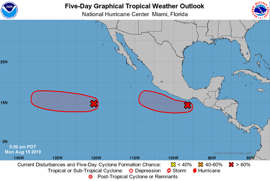
The first system is located closest to the Mexican coast but isn’t expected to directly impact the U.S. According to the National Hurricane Center, a low pressure system located less than 200 miles south of the southern coast of Mexico continues to produce a large area of cloudiness of thunderstorms. Environmental conditions are conducive for development, and a tropical depression is likely to form during the next day or so while the low moves west-northwestward at about 10 mph, parallel to and just offshore of the coast of Mexico. Moisture associated with this disturbance could produce heavy rainfall and possible flash flooding across portions of Guatemala and southeastern Mexico during the next couple of days. The National Hurricane Center believes there’s an 80% chance that a tropical cyclone will form here over the next 48 hours and a 90% chance that one will form over the next 5 days.
Another system of greater concern is located in the open waters of the eastern Pacific; over time, this could bring trouble to Hawaii. The low pressure system is located more than 900 miles southwest of the southern tip of the Baja California peninsula; it is producing a large area of cloudiness and disorganized thunderstorms today. According to the National Hurricane Center, environmental conditions are expected to become more conducive for development by mid-week, and a tropical depression is likely to form during the next few days while the system moves westward to west-northwestward at about 10 mph. The National Hurricane Center believes there’a 60% chance of tropical cyclone formation over the next 60 hours; this increases to 80% over the next 5 days. Additionally, the American GFS computer forecast model does suggest that this storm could bring direct or indirect impacts to Hawaii as a tropical cyclone in about 10 days.
While activity in the Pacific picks up, the Atlantic remains quiet. According to Dr. Phil Klotzbach, who leads the Tropical Meteorology Project at Colorado State University, the last time there’s been no activity in the Atlantic from July 15 through August 19 was in 1982. We asked Dr. Klotzbach about the last times there were no hurricanes through the end of August from mid-July; he responded, “It’s happened twice since NHC records began in 1851: 1914 and 1922. Of course, we probably missed a few storms in those years, given the limited observational network we had at the time.”
