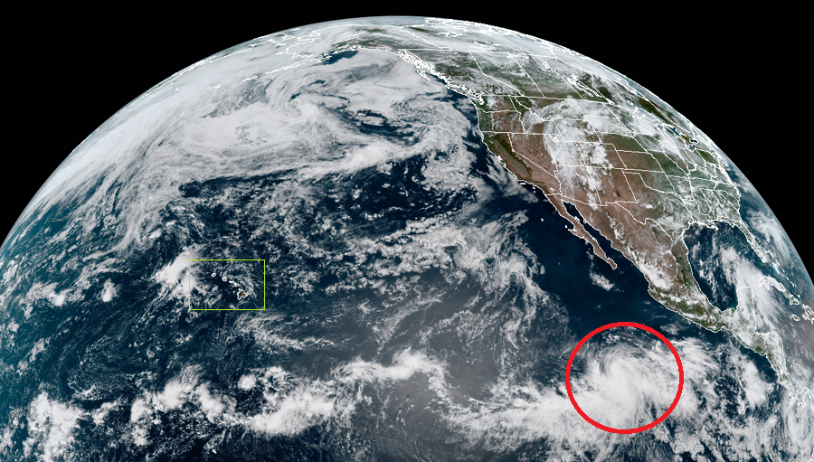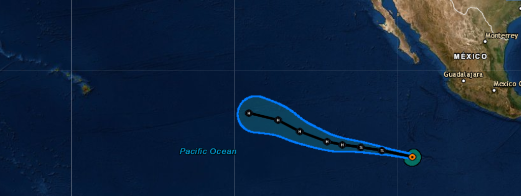
Tropical Storm Barbara, the second named storm of the 2019 Eastern Pacific Hurricane Season, could grow into a hurricane, move into the Central Pacific Basin, and bring impacts to Hawaii over time. Residents and visitors in Hawaii after the Fourth of July are encouraged to closely monitor the future progress of this storm; due to how isolated Hawaii is, people there should make sure they have 2 weeks of supplies, like food, water, prescription drugs, fuel, and cash long before any threat materializes in the Aloha State.
According to the National Hurricane Center in south Florida, the cloud pattern of Barbara is slowly becoming better organized, with a curved convective band now forming in the southeastern semicircle. A recent analysis indicates that maximum sustained winds have increased to near 46 mph and that a large area of tropical storm force winds now wraps more than halfway around the center. However, analysis of wind data also shows a significant trough extending southwestward from the center into the Intertropical Convergence Zone which could limit some strengthening initially.
The National Hurricane Center (NHC) believes a mid-level ridge to the north of the cyclone should steer it westward to west-northwestward for the next 2 days with a gradual decrease in forward speed. After that, a weakness in the ridge should allow a west- northwesterly motion for the rest of the forecast period. The track guidance remains fairly tightly clustered between an American forecast model on the north side and a European forecast model on the south side.
Some northwesterly vertical wind shear continues to affect Barbara, and this should persist for another 12 hours or so. After that, the National Hurricane Center believes the tropical cyclone should be in an environment of light shear and over warm sea surface temperatures through the next 3 days. Based on these ideal conditions, the intensity forecast from the NHC calls for slow development through 12 hours and a faster rate of development thereafter. The various rapid intensification indices suggest a 40-50 percent chance of rapid intensification from 12 to 72 hours, and if this occurs, Barbara could become a major hurricane with maximum sustained winds of 125 mph or greater.

Beyond 72 hours, questions arise with what Barbara could do next. Some forecast tracks from computer guidance bring the system over cooler waters and increased sheer which could inhibit growth or even weaken it. Generally, the system will be approaching Hawaii and at the least, it is becoming likely indirect impacts to the Big Island are possible over time in the form of rough surf and the potential for coastal flooding. Should the storm or its remnants get closer, more direct impacts are possible in the form of heavy rain and strong winds. The latest American GFS forecast model suggests the center of Barbara will pass near or over Hawaii’s Big Island around July 10, although in a weaker form than it is now. Even if Barbara lost most tropical storm characteristics by then, extremely heavy rains could impact the state. It is important to note that extended forecast guidance with tropical cyclones is prone to error which could be significant, in both storm strength and storm intensity.
To prepare residents for potential tropical cyclone impacts, Hawaii County Civil Defense just hosted a Disaster Preparedness Fair. The Central Pacific Hurricane Center, based in Honolulu, co-located with the National Weather Service office there, is forecasting an above-normal hurricane season around Hawaii this year. With potential threats from Barbara and other possible storms in the pipeline, it is key that people heed Civil Defense’s advice on Hawaii and prepare sooner rather than later for any tropical cyclone threat.
The Central Pacific Hurricane Center will “take over” issuing advisories for this storm once it moves west of 140°W. The Central Pacific Hurricane Center works in tangent with the National Hurricane Center and the National Weather Service to keep people safe from any tropical cyclone threat impacting the U.S.
NOAA's Central Pacific Hurricane Center (CPHC) Director, Chris Brenchley, described to us today how his Honolulu team coordinates, collaborates, & even swaps staff with Miami-based National Hurricane Center (NHC) to keep America #HurricaneStrong?@NWSHonolulu pic.twitter.com/W1WM2EeXeC
— the Weatherboy (@theWeatherboy) May 23, 2019