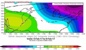
With blizzard conditions impacting portions of the Northeast last Thursday and a fresh blizzard impacting New England and especially Maine today into tomorrow, many questions remain on the table: Will the cold weather stick around? Can we expect any more snow?
We spent time with Joseph Renken, founder of the Bering Sea Rule (BSR), to get his thoughts on what is occurring now across the Continental United States and what the BSR and other long range tools say is in store for the rest of the winter.

Though not overly optimistic for a sustained snowy and cold pattern to setup in the Northeast and Mid-Atlantic, Renken did offer some hope after the region gets through a very mild stretch of weather coming up the next week or so. “The BSR depicted this past snow event on Wednesday night and Thursday for the mid-Atlantic and the Northeast very well.” Renken added, “A trailing wave of low pressure that developed into the Thursday snowstorm was portrayed nicely by what was going on in the Bering Sea around January 22.”
A troughy pattern in the Northeast was expected around the 9th and 10th of this month which led to the area of low pressure system spinning up. Behind this system, an air mass with Pacific origins will dominate the entire continental US. A much stronger than normal jetstream over the eastern Pacific will force this air mass inland. The much stronger than normal Pacific jetstream has been a persistent feature for much of this entire winter and is at least partly responsible for the mild temperatures experienced so far in the east
This is a warm pattern upcoming for much of the U.S., especially east of the Rockies. In the 10 day period ending around the 22nd of this month, many areas of the country will be 10 degrees above normal with some as high as 20 degrees above normal. Though New England will be the slowest to warm, after the current blizzard departs, temperatures will soar even there to well above normal readings about a week from now. While they warm slowly in New England, temperatures in the Midwest, Great Lakes and South will be well above normal for much of this upcoming week.
“A strong area of high pressure over the North Pacific near the Gulf of Alaska retrograded, meaning it headed west, instead of the normal east that most weather systems take (in late January) and this teleconnected to a ridge of high pressure off the Southeast coast heading west and dominating the eastern US,” explains Renken. This type of weather pattern encourages a strong west to east flow across the Lower Forty Eight and will combine with the much stronger than normal Pacific jetstream to allow warmth to dominate.
While the pattern indicates a warm stretch of weather, a change is also likely around the 20th of the month. “This very well could be another severe weather outbreak with the Southeast with the Gulf Coast states being the area seeing the greatest threat for severe weather,” Mr. Renken stressed.
This storm will be followed by a change to more normal temperatures. Mr. Renken explained, “The stronger than normal jetstream slamming into California has been the overwhelming meteorological factor in our mild winter so far. And there is no sign of this factor going away. Plus Canada has been running way above normal temperature-wise. Combining these and other factors, I don’t think a pattern of sustained cold in the East will exist.” After the stormy period that’ll set-up around February 20-22 and into March, the BSR indicates a volatile back and forth temperature pattern with some cold snaps but the cold is generally muted.
By the time the calendar turns to March, coastal cities and ones south of the Mason-Dixon Line are running short on time in terms of meaningful snowfall. If a snowstorm does not happen with the 1st week or two of March in cities like Baltimore, Washington D.C. and Philadelphia, the clock has ran out time for snow lovers. Further to the north and inland, snowstorms can occur a bit later.
When the winter of 2016-17 is in the books, most of the country will be above average temperature-wise. California will remember it as a bumper year in terms of rain and snow, one that they sorely needed. But for snow lovers in the Northeast and mid-Atlantic, it appears short of a few localized blizzards, the winter will be known for its near misses and rainstorms.