• Skip to primary navigation
  • Skip to main content
  • Skip to primary sidebar

Weatherboy

Weatherboy Weather News, Maps, RADAR, Satellite, and Forecasts.

  • Local
  • Earth Science News
  • RADAR
  • Current Warnings
  • Satellite
  • Current Maps
  • Forecast Maps
  • Video

Severe Weather Threat & Tornado Risk Returns to Northeast Today

by Weatherboy Team Meteorologist - June 28, 2025

While thunderstorms are possible in any color shaded area, the dark green has an elevated threat of severe thunderstorms while the yellow one has an even higher threat level. Image: NWS SPC

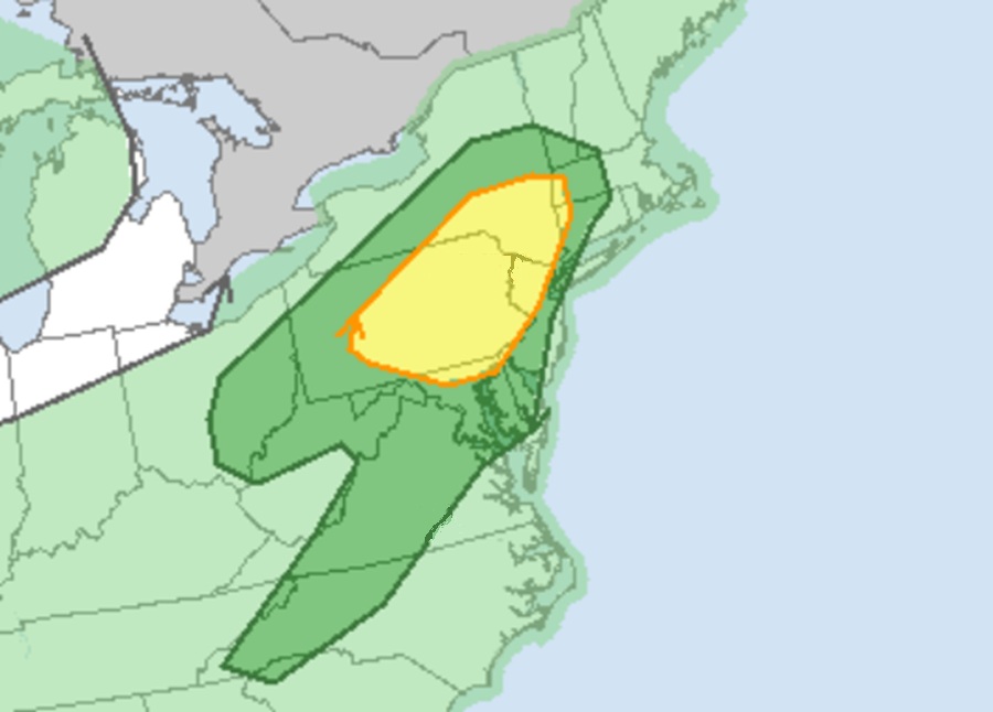
The threat of severe weather and the risk of isolated tornadoes is returning to the northeast today, prompting the National Weather Service to issue a Severe Thunderstorm Watch for the area.  The threat of severe weather exists from western North Carolina north into Virginia, Maryland, Delaware, New Jersey, New York, western Connecticut and Massachusetts, southern Vermont, and west into Pennsylvania, eastern Ohio, and northern West Virginia. The greatest threat of tornadoes in this area is across northeastern Pennsylvania into southeast Upstate New York.

A Severe Thunderstorm Watch was issued for the area in blue on this map.  Image: NWS
A Severe Thunderstorm Watch was issued for the area in blue on this map. Image: NWS

The National Weather Service’s Storm Prediction Center (SPC) has issued a Severe Thunderstorm Watch for much of central New York and Pennsylvania; additional watches to the east may become necessary later in the day.

A surface cold front is sagging southward into New York and western Pennsylvania today is responsible for this severe weather threat.   Thunderstorms have begun to intensify along/ahead of the front, with locally damaging wind gusts expected through the afternoon. According to the SPC, low clouds are limiting heating and atmospheric destabilization over eastern New York, Pennsylvania, and the Mid Atlantic region. However, heating should begin by late afternoon, allowing storms approaching from the west to maintain a damaging wind threat into the early evening.


Primary Sidebar

Sponsored Ad

Search

Latest News

  • Harvard Scientist Tracking 3I/Atlas Believes New Photos May Show Alien Spacecraft Engines
  • Geomagnetic Storm Watch for MODERATE Storm November 8
  • Alien Spaceship or Unusual Comet? More Demand Answers on Color/Speed/Shape Shifting Object in Space
  • 31+ Quakes Rattle Texas Today: Likely Fracking Related
  • Damaging Wind Gusts and Snow Squalls Possible in Northeast on Wednesday
  • 300+ Earthquakes Rock Caribbean, Still No U.S. East Coast Tsunami Threat
  • Atlantic Hurricane Basin Quiets with 4 Weeks of Season To Go
  • Quake Rattles Heart of New Madrid Seismic Zone in Missouri
About | Careers | Contact | Contests
Terms | Privacy | Ad Choices
Weatherboy is a (R) Registered Trademark of isarithm LLC, All Rights Reserved.
All content herein is Copyright by Isarithm LLC 1997-2022

Insert/edit link

Enter the destination URL

Or link to existing content

    No search term specified. Showing recent items. Search or use up and down arrow keys to select an item.