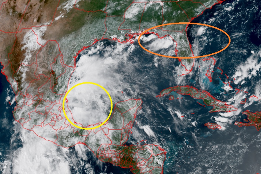
Meteorologists at the National Hurricane Center in Miami, Florida are busy today tracking two systems in the Atlantic Hurricane Basin: the first is Tropical Storm Barry in the Bay of Campeche, the other is an area of disturbed weather that could develop into a tropical cyclone in the coming days near Florida.
Air Force Reconnaissance data indicates that maximum sustained winds inside Tropical Depression #2 have increase to near 40 mph with higher gusts, making it the second tropical storm of the 2025 Atlantic Hurricane Season. Named Barry, the National Hurricane Center (NHC) says that a little more intensification is forecast before the system reaches the coast of eastern Mexico. Rapid weakening is expected after the system moves inland.
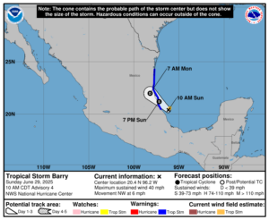
Right now, Barry is located about 90 miles east-southeast of Tuxpan, Mexico and about 165 miles southeast of Tampico, Mexico. Barry is moving to the northwest at 6 mph. Barry’s minimum central pressure is 1006 mb or 29.71″.
The Government of Mexico has issued a Tropical Storm Warning for the Gulf coast of Mexico from Boca de Catan southward to Tecolutla. A Tropical Storm Warning means that tropical storm conditions are expected somewhere within the warning area, in this case within 12-24 hours.
Tropical Storm Barry is expected to produce rainfall totals of 3-6″, with isolated maximum totals of 10″ across the Mexican states of Veracruz, San Luis Potosi, and Tamaulipas through Monday. This rainfall may produce life-threatening flooding and mudslides, especially in areas of steep terrain. Tropical storm force wind conditions, especially in gusts, are expected in the tropical storm warning area beginning this afternoon.

While remnant moisture from Barry could enter Texas, a greater potential threat to the U.S. could develop near Florida in the coming days. According to the NHC, towards the end of this week into next weekend, an area of low pressure could develop from a remnant frontal boundary near or along the southeastern U.S. Atlantic and or Gulf coasts.
“Some gradual tropical or subtropical development could occur,” cautions the NHC in their latest Tropical Outlook, as the system drifts slowly just off the U.S. coastline. Any development will be slow; for now, the NHC says there’s only a 20% chance of tropical cyclone formation over the next 7 days for now.
The Atlantic Hurricane Season began on June 1 and runs through to the end of November.
