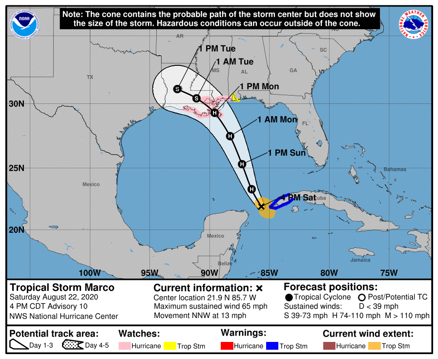
The National Hurricane Center has announced a big change to their forecast thinking for what will be Hurricane Marco soon, prompting them to issue Hurricane and Storm Surge Watches for the U.S. coast. With maximum sustained winds of 65 mph now, Marco is just shy of hurricane force, but it is expected to become a hurricane soon. Because the storm won’t cross over the Yucatan Peninsula, is expected to slam into the central Gulf Coast as a full-blown hurricane.
Because of the forecast change, the National Hurricane Center has issued a Storm Surge Watch from Sabine Pass eastward to the Alabama/Florida border, including Lake Pontchartrain, Lake Maurepas, Lake Borgne, and Mobile Bay. A Hurricane Watch has been issued from Intracoastal City, Louisiana eastward to the Mississippi/Alabama border, including Lake Pontchartrain, Lake Maurepas, and Metropolitan New Orleans. A Tropical Storm Watch has been issued from the Mississippi/Alabama border eastward to the Alabama/Florida border. Meanwhile, the government of Mexico has discontinued the Tropical Storm Warning for the northeastern Yucatan coast.
A Storm Surge Watch means there is a possibility of life-threatening inundation, from rising water moving inland from the coastline, in the indicated locations during the next 48 hours. A Hurricane Watch means that hurricane conditions are possible within the watch area. A watch is typically issued 48 hours before the anticipated first occurrence of tropical-storm-force winds, conditions that make outside preparations difficult or dangerous. A Tropical Storm Watch means that tropical storm conditions are possible within the watch area, generally within 48 hours.
As of the latest update issued by the National Hurricane Center at 4pm CT / 5pm ET, the center of Tropical Storm Marco was located near latitude 21.9 North, longitude 85.7 West, roughly 540 miles south southeast of the mouth of the Mississippi River. Marco is moving toward the north-northwest near 13 mph and it is expected to continue moving toward the north-northwest across the central Gulf of Mexico on Sunday and is forecast to reach the northern Gulf coast on Monday. After moving inland, Marco is expected to slow down and turn toward the northwest and west-northwest Monday night and Tuesday, moving across southern Louisiana into east Texas. Marco is forecast to become a hurricane tonight and remain so as it moves over the New Orleans metropolitan area on Monday. Once Marco moves inland, weakening is forecast to occur while the center moves farther inland Monday night and
Tuesday.
The combination of a dangerous storm surge and the tide will cause normally dry areas near the coast to be flooded by rising waters moving inland from the shoreline. The water could reach the following heights above ground somewhere in the indicated areas if the peak surge occurs at the time of high tide:
- Grand Isle,Louisana to the Alabama / Florida Border including Lake Borgne and Mobile Bay: 3-5′
- Lake Pontchartrain and Lake Maurepas: 2-4′
- Sabine Pass to Grand Isle, Louisiana: 2-4′
The deepest water will occur along the immediate coast in areas of onshore winds, where the surge will be accompanied by large and destructive waves. Surge-related flooding depends on the relative timing of the surge and the tidal cycle, and can vary greatly over short distances.
Hurricane conditions are possible within the hurricane watch area by midday Monday, with tropical storm conditions possible by early Monday. Tropical storm conditions are possible within the tropical storm watch area on Monday. Tropical storm conditions are expected to continue within the warning area in Cuba through this evening.
Marco will produce very heavy rains which could create serious flood problems. In far western Cuba, 2-4″ of rain is expected with isolated amounts near 6″. The eastern portions of the Mexican states of Quintana Roo and Yucatan will see 1-3″. The central U.S. Gulf Coast will see at least 1-3″ with amounts up to 5″ possible in some areas.
