• Skip to primary navigation
  • Skip to main content
  • Skip to primary sidebar

Weatherboy

Weatherboy Weather News, Maps, RADAR, Satellite, and Forecasts.

  • Local
  • Earth Science News
  • RADAR
  • Current Warnings
  • Satellite
  • Current Maps
  • Forecast Maps
  • Video

Blizzard of 2018 Continues; 1-2′ Snow Possible for Some

by Weatherboy Team Meteorologist - January 4, 2018

Heavy snow, in excess of 1 foot, is expected in the red areas on the map. Image: Weatherboy


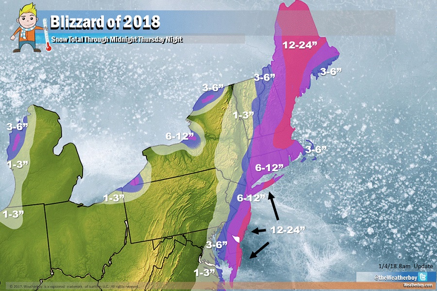
The Blizzard of 2018 continues in the northeast today, after dropping record amounts of snow and ice across the deep south of Florida, Georgia, and South Carolina yesterday. The worst of the blizzard conditions today will be along coastal areas of Virginia, Maryland, Delaware, New Jersey, Long Island, and eastern New England.

The heaviest snow from this storm, which will be in the 1-2 feet range, will be confined to coastal northeastern Virginia, coastal eastern Maryland, southeastern Delaware, the Jersey Shore, central Long Island, the Boston Metro area, coastal New Hampshire, and central Maine.


Rain and/or mixed precipitation will keep totals down a bit for Cape Cod and nearby islands and the northeast coast of Maine.

Strong winds will blast the northeast, with some gusts approaching hurricane force near the coast. Image: NWS

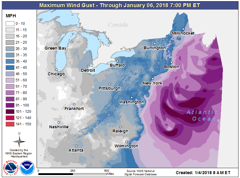
In addition to heavy snow, strong, potentially damaging winds will blast through the northeast. Strong winds are responsible for the blizzard conditions: blizzard criteria is met when winds of 35mph or greater exist for at least 3 hours with visibility reduced to 1/4 mile or less for the same amount of time. The wind-whipped white out conditions will bring areas under a Blizzard Warning to those criteria today into tonight. Even outside of the Blizzard Warning areas, strong winds will blow and drift snow well away from the coast, making travel hazardous even in areas not expecting significant snowfall amounts. Strong winds will also knock down trees, tree branches, and power lines, possibly leaving many without power or heat for a prolonged period of time.


The Blizzard of 2018 will wrap-up from southwest to northeast late today into early tomorrow.


Primary Sidebar

Sponsored Ad

Search

Latest News

  • Significant Earthquake Swarm Strikes Nevada East of Lake Tahoe & Carson City
  • U.S. About to Be Hit By Sinlaku, Most Powerful Storm on Planet
  • Artemis II Mission Splashes Down After Breaking Human Spaceflight Records
  • Kilauea Volcano Erupts in Middle of Major Winter Storm
  • Atlantic Hurricane Outlook Signals Trouble for Hawaii
  • Atlantic Hurricane Seasonal Outlook Released; El Nino to Make Big Impact
  • Meteor Explodes Over New Jersey
  • Two TV Meteorologists Diagnosed with Cancer; Tackle Treatments Now
About | Careers | Contact | Contests
Terms | Privacy | Ad Choices
Weatherboy is a (R) Registered Trademark of isarithm LLC, All Rights Reserved.
All content herein is Copyright by Isarithm LLC 1997-2022

Insert/edit link

Enter the destination URL

Or link to existing content

    No search term specified. Showing recent items. Search or use up and down arrow keys to select an item.