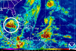
Experts at the National Hurricane Center (NHC) are closely monitoring an area of disturbed weather in the Caribbean south of Cuba that could become a tropical cyclone over time. Even if it doesn’t, it is likely to head over areas in Florida hit hard by Hurricane Irma, bringing unwanted heavy rain and breezy conditions there.
A large area of cloudiness and showers extending from the northwestern Caribbean Sea across Cuba to the Bahamas is associated with a broad surface trough interacting with an upper-level low. According to the NHC, a weak area of low pressure is likely to form from this weather system while it moves northward across Cuba and near the east coast of the Florida peninsula during the next few days. “Environmental conditions appear conducive for development before upper-level winds become less favorable early next week,” the NHC says in their five day tropical outlook.
The NHC believes there’s a 20% chance of formation over the next 2 days and 40% chance of formation over the next 5 days. These percentages are higher today than they were yesterday.
The 2017 Atlantic Hurricane Season has been a busy one, with five major hurricanes, the highest number since 2010, as well as the most accumulated cyclone energy (ACE) since 2005. The season runs through the end of November.