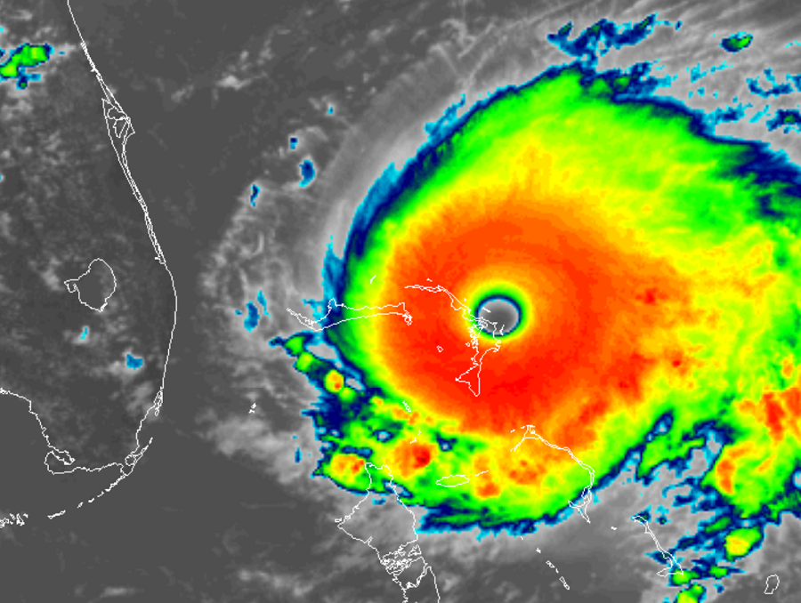
An absolutely catastrophic impact to the Bahamas is underway as Major Hurricane Dorian, a top Category 5 hurricane, smashes through the Abaco Islands. Dorian is now the second most potent hurricane ever recorded in the Atlantic basin with maximum sustained winds of 185 mph and gusts over 220 mph. To put storms in perspective, Dorian is roughly 1,300 times more potent than Sandy was when it came ashore New Jersey in 2012, devastating portions of New Jersey and New York when it did so.
Destructive winds, heavy rains measured in yards, and a high storm surge in excess of 22 feet are all expected in the Bahamas as the hurricane slowly inches its way closer to Florida.
Many watches and warnings are now in effect for Dorian. For now, a Storm Surge Watch is in effect for portions of Florida north of Deerfield Beach to the Volusia/Brevard County Line. A Hurricane Warning is in effect for Northwestern Bahamas excluding Andros Island where a Hurricane Watch is in effect. The Hurricane Watch is also in effect for portions of Florida north of Deerfield Beach to the Volusia/Brevard County Line. A Tropical Storm Warning is in effect for portions of Florida north of Deerfield Beach to Sebastian Inlet. A Tropical Storm Watch is in effect in Florida for areas north of Golden Beach to Deerfield Beach and for all of Lake Okeechobee. A Storm Surge Watch means there is a possibility of life-threatening inundation, from rising water moving inland from the coastline, in the indicated locations during the next 48 hours. A Hurricane Warning means that hurricane conditions are expected somewhere within the warning area. Preparations to protect life and property should be rushed to completion. A Hurricane Watch means that hurricane conditions are possible within the watch area. A watch is typically issued 48 hours before the anticipated first occurrence of tropical-storm-force winds, conditions that make outside preparations difficult or dangerous. A Tropical Storm Warning means that tropical storm conditions are expected within the warning area within 36 hours. A Tropical Storm Watch means that tropical storm conditions are possible within the watch area, generally within 48 hours.
Additional watches and warnings may be necessary for other locations in Florida and further up the U.S. East Coast later today.
At 2:00pm ET, the extremely distinct eye of Hurricane Dorian was located near latitude 26.5 North, longitude 77.1 West. Dorian is moving toward the west near 7 mph . A slower westward motion should continue for the next day or two, followed by a gradual turn toward the northwest. On this track, the core of extremely dangerous Hurricane Dorian will continue to pound Great Abaco today and the move near or over Grand Bahama Island tonight and Monday. The hurricane should move closer to the Florida east coast late Monday through Tuesday night. Hurricane-force winds extend outward up to 45 miles from the center and tropical-storm-force winds extend outward up to 140 miles. The minimum central pressure measured by both NOAA and Air Force reconnaissance plane was 911 mb or 26.90 inches.
The storm is forecast by computer models to turn to the north. However, until that turn occurs, if it does occur, people on Florida should remain on high alert for the possibility of a catastrophic landfall there.
Even with a northward turn, the rest of the U.S. East Coast is at risk for direct impacts from this hurricane. It is becoming more likely that Georgia, South and North Carolina, Virginia, Maryland, Delaware, New Jersey, and Massachusetts will see damaging impacts from this storm over time. People up and down the entire U.S. East Coast from Florida to Maine should make sure they have a Hurricane Action Plan; those in Florida should be acting on it no later than today.