• Skip to primary navigation
  • Skip to main content
  • Skip to primary sidebar

Weatherboy

Weatherboy Weather News, Maps, RADAR, Satellite, and Forecasts.

  • Local
  • Earth Science News
  • RADAR
  • Current Warnings
  • Satellite
  • Current Maps
  • Forecast Maps
  • Video

Cindy’s Remnants Dump Heavy Rain

by Weatherboy Team Meteorologist - June 23, 2017

Forecast rainfall amounts through Saturday, with heavier amounts enhanced by the remnants of Tropical Storm Cindy. Map: weatherboy.com

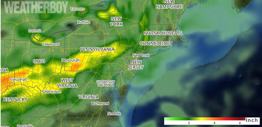
Tropical Storm Cindy made landfall early Thursday morning near the Texas/Louisiana coast, but its remnants are making its way to the Ohio Valley and Mid Atlantic.   More than 3″ of rain may fall over portions of Indiana, Kentucky, West Virginia, and Pennsylvania.


The combination of decaying Cindy lifting north and east up the Ohio River towards the northern Mid Atlantic states combined with multiple shortwave impulses will result in widespread heavy to excessive rainfall today and early tomorrow. Cindy’s remnants are expected to advance from east central Arkansas to northern Kentucky to Maryland/northern Virginia over the next 23 hours. During this trip, Cindy will continue to  weaken and will eventually become part of the progressive jet. Meanwhile, an active cold front with a secondary frontal zone will sweep from the Great Lakes to the Northeast while the tail end of the front settles into the south near the Lower Mississippi River Valley.

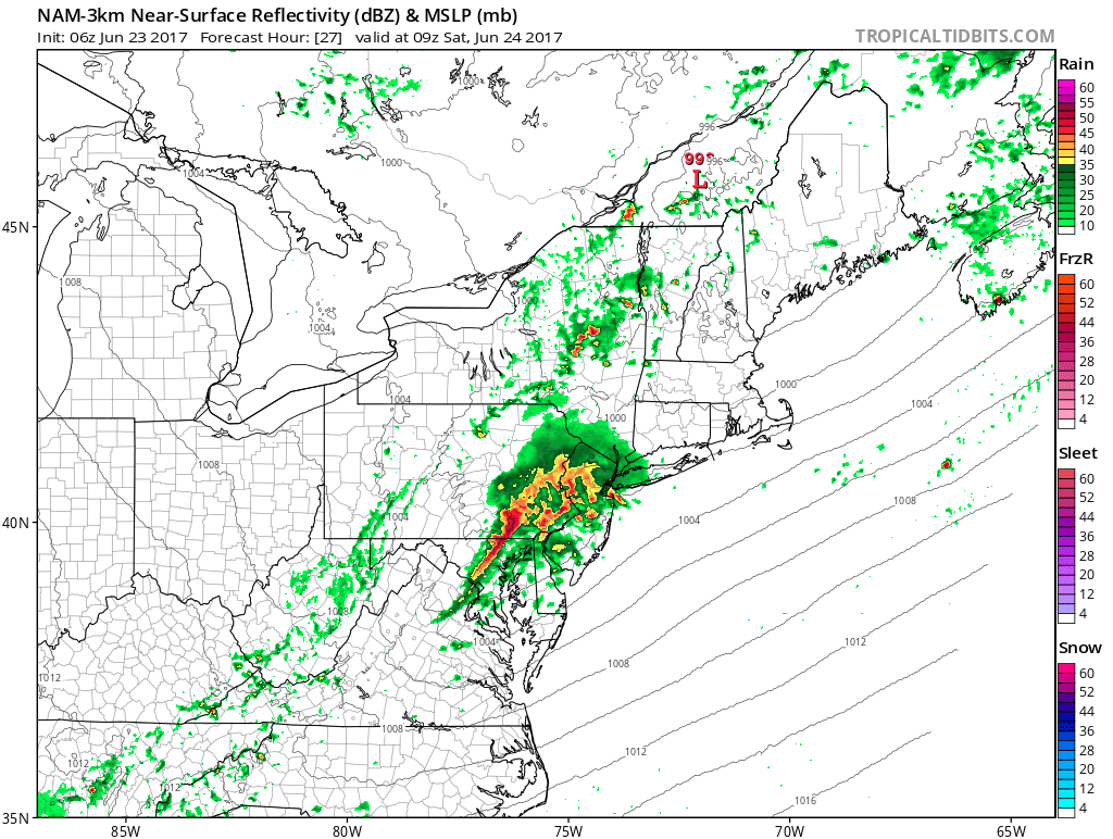
While Cindy is bringing plenty of moisture north, the frontal system will act as a trigger mechanism to create convective cells. These thunderstorm cells will produce heavy rainfall rates and amounts. Due to the short duration of very heavy rain, there could be flash flood concerns. Remember, turn around, don’t drown; never drive through flood waters.


Short-duration, high-resolution computer forecast model RADAR simulation shows an area of heavy rain moving through the Mid Atlantic early Saturday morning. Map: TropicalTidbits.com

The frontal system will help push Cindy’s remains out to sea on Saturday, with fair high pressure building in from West to East.

On Saturday, these are the times we believe rainfall will be gone from the area; if the frontal system is a bit faster than forecast, these end times may end even earlier by a few hours.

Washington, DC: 12 noon

Baltimore, MD: 1pm

Philadelphia, PA: 2pm

Trenton, NJ: 3pm

New Brunswick, NJ: 4pm

New York City, NY: 6pm

Atlantic City, NJ: 6pm


Primary Sidebar

Sponsored Ad

Search

Latest News

  • Storm Surge Likely from South Carolina to New Jersey as Ophelia Makes Landfall
  • Tropical Storm Ophelia Continues to Gain Strength
  • Earthquake Rattles Northeast Ohio
  • Mid Atlantic Braces for Impacts from Ophelia: Tropical Storm Force Winds, Flooding Rains, Tornadoes, Life Threatening Storm Surge
  • North Carolina to New Jersey on Alert as Coastal Storm Takes Shape
  • Strong Geomagnetic Storm Blasts Earth, Triggers Aurora Across Central States, Mid Atlantic
  • National Hurricane Center Tracking 3 Atlantic, 1 Pacific Systems
  • Volcanic Eruption Ends in Hawaii; Gasses Spewing from Kilauea Greatly Reduced, Clearing Air
About | Careers | Contact | Contests
Terms | Privacy | Ad Choices
Weatherboy is a (R) Registered Trademark of isarithm LLC, All Rights Reserved.
All content herein is Copyright by Isarithm LLC 1997-2022