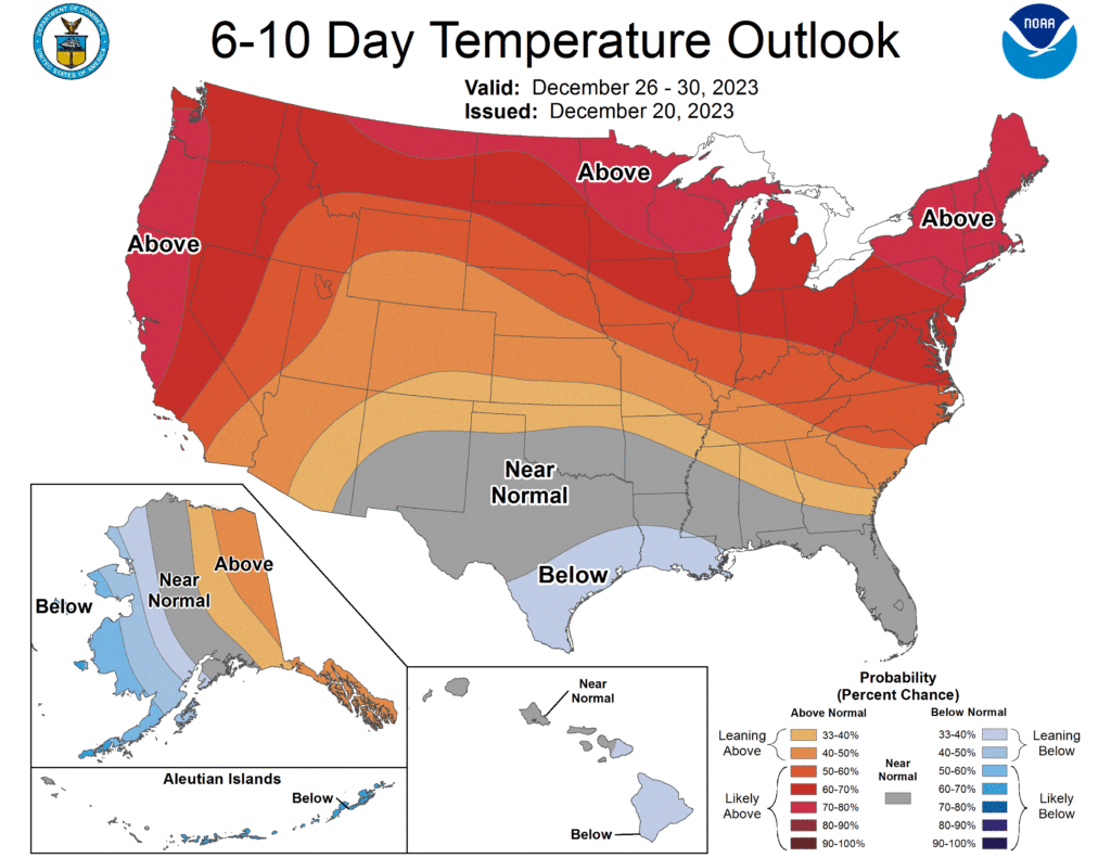
The National Weather Service’s Climate Prediction Center says that Christmas week will be a wild one for most of the U.S., with below-normal temperatures limited to southern Texas and Louisiana, western Alaska, and Hawaii’s Big Island. The West Coast, the Upper Plains, the Great Lakes, and the Northeast are all forecast to see above normal temperatures.
A variety of weather factors around North America, influenced by El Nino in the Pacific, are responsible for this weather pattern for now. Deep troughing over the North Pacific, weak negative height anomalies over the south-central and southeastern contiguous U.S. (CONUS), and expansive positive height anomalies covering much of the northern CONUS and almost all of Canada is creating an atmospheric set-up in which above-normal temperatures are likely for much of the CONUS.
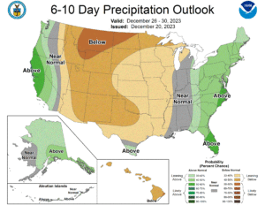
In addition to above-normal temperatures, this type of pattern also creates above-normal precipitation for both coasts and generally below-normal precipitation for the Mountain West and Great Plains.
According to the Climate Prediction Center (CPC), with positive height anomalies over Canada confining colder air to higher latitudes, above-normal temperatures are favored for most of the CONUS, especially for the Northern Tier and along the West Coast where probabilities exceed 70%. As cooler Pacific air moves eastward across and out of the Desert Southwest, near-normal temperatures are favored for much of New Mexico as well as portions of the Southern Plains, Southern Mississippi Valley, and Southeast U.S. Ridging over Canada and troughing over the North Pacific favors a split
forecast for Alaska. For Hawaii, the forecast tools used by the National Weather Service suggest near-normal temperatures for most of the Islands except for the Big Island and eastern Maui, which tilts slightly towards below normal temperatures.
Deep troughing over the North Pacific and a secondary trough over the eastern CONUS results in a fairly wet pattern for the coasts. According to the CPC, probabilities for above-normal precipitation are highest for portions of Florida, eastern North Carolina, and southeastern Virginia (>50%), and enhanced probabilities extend up the East Coast and over the Appalachians. Above-normal precipitation is also favored for the West Coast, particularly for northern California, but probabilities for above normal precipitation do not extend very far past the Sierra Nevada mountain range. Below-normal precipitation is indicated from the Great Basin east to roughly the Mississippi River, with higher odds for the Northern Plains, Rocky Mountains, and much of central and northern Texas. Southerly flow off the North Pacific tilts most of Alaska towards above-normal precipitation while near-normal precipitation is most likely for the southwestern portion of the state.
