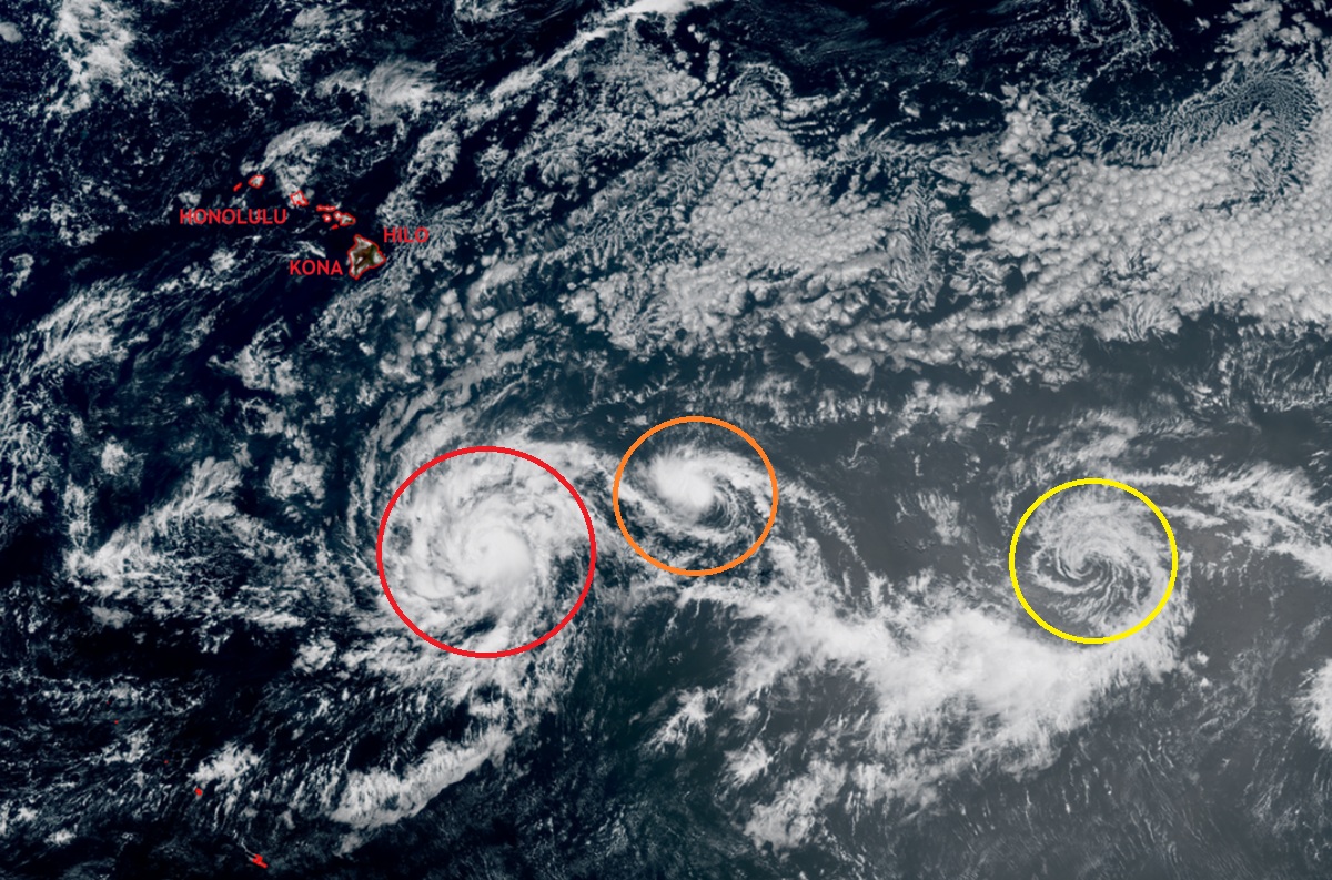
The waters south of Hawaii have blossomed with dramatic strengthening tropical cyclones today, with the rapid intensification of Hurricane Iona, the formation of Tropical Storm Keli behind it, and a third storm on the way behind the other two. While all three storms are fierce or forecast to be, they should stay well south of Hawaii and not directly impact any of the islands within the chain over the next several days.
Hurricane Iona is located about 870 miles south-southeast of Honolulu, Hawaii on the island of Oahu or 10.6 N 151.0 W. With maximum sustained winds of 75 mph, the system which was only a tropical depression yesterday this time has rapidly intensified with additional strengthening likely. The hurricane is moving west at 10 mph while the minimum central pressure has dropped to 993 mb or 29.33″. According to the Central Pacific Hurricane Center and the National Hurricane Center, this westward motion is expected to continue with a gradual increase in forward speed during the next couple of days. While Iona should gain strength for the next 48 hours, gradual weakening is likely beyond that as it approaches colder ocean waters. The hurricane will remain well south of Hawaii and bring no direct impacts to the islands.

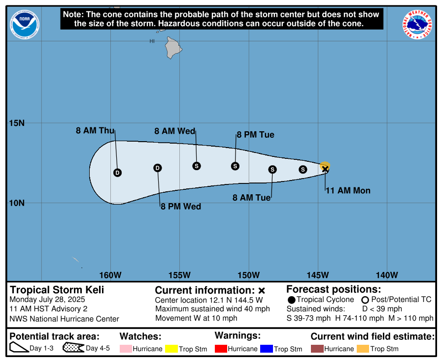
A tropical depression that quickly organized has now strengthened to Tropical Storm Keli. Located at 12.1 N 144.5 W which puts it about 1,090 miles southeast of Honolulu, Hawaii. The pressure has dropped to 1008 mb or 29.77″ while maximum sustained winds have grown to 40 mph. The storm is moving west at 10 mph. Like Iona, Keli is forecast to strengthen some over the next day or two with gradual weakening expected beyond that. Keli is not expected to directly impact any of the Hawaiian Islands either.
A third system east of Iona and Keli has caught the attention of the National Hurricane Center too. Showers and thunderstorms associated with an area of low pressure located about 1,600 miles east-southeast of the Hawaiian Islands have decreased in coverage this morning. However, they say that environmental conditions appear conducive for gradual development, and a tropical depression could form during the next day or two. The National Hurricane Center believes there’s a 60% chance that a tropical depression will form here over the next 48 hours. As with Iona and Keli, this third system is expected to pass well south of Hawaii.
Throughout Hawaii, light to moderate trades and sea breezes over leeward areas will continue today as a low level trough drifts westward through the island chain. Higher humidity levels will also continue along with increasing showers over the central and western islands. The weather pattern will change a bit on Tuesday as the ridge builds back into the region and locally breezy trade winds return with stable and rather dry conditions statewide lasting into next weekend.
While the tropical cyclones are forecast to pass far south of the Hawaiian Islands, there could be some interaction with the local trade winds. According to the Honolulu office of the National Weather Service, trade wind speeds may increase slightly as these tropical systems pass far south of the islands, lowering subsidence temperature inversion heights, and limiting clouds and showers from Wednesday through Friday. It is also possible that when the storms make their closest approach to Hawaii, near critical fire weather conditions could be possible for Maui and the Big Island lasting into the weekend as dry air lingers over Hawaii while the moisture from the tropical cyclones heads far south and away form Hawaii. A few leeward areas of Maui and the Big Island may briefly reach fire weather minimum humidity thresholds for a few hours each afternoon, however the sustained wind speeds are forecast to remain just below critical thresholds.
With drought and ongoing fire weather concerns in Hawaii, the National Weather Service will continue to monitor this threat, no matter how small the chances of reaching fire weather criteria are.
Beyond this subtle change to the trade winds, the Honolulu National Weather Service office is telling people in Hawaii to expect higher humidity levels in a hybrid trade wind and sea breeze pattern today, as a low level disturbance moves westward through the islands mitigating fire weather concerns for now. Drier and more stable conditions will return as the high pressure ridge builds back in from Tuesday onward.
