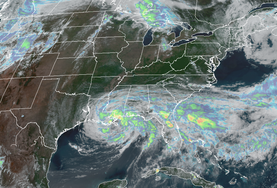
Tropical Storm Cristobal is in the process of making landfall near Venice, Louisiana, roughly 90 miles southeast of New Orleans. Storm Surge and Tropical Storm Warnings remain in effect around the Gulf Coast.
For now, a Storm Surge Warning is in effect for the Mouth of the Mississippi River where Cristobal is centered east to Ocean Springs, Mississippi. A Storm Surge Warning is also in effect for Lake Borgne. A Storm Surge Watch is in effect from east of Morgan City, Louisiana to the mouth of the Mississippi River. A Storm Surge Warning means there is a danger of life-threatening inundation, from rising water moving inland from the coastline, during the next 36 hours in the indicated locations. The National Hurricane Center warns, “This is a life-threatening situation. Persons located within these areas should take all necessary actions to protect life and property from rising water and the potential for other dangerous conditions. Promptly follow evacuation and other instructions from local officials.” A Storm Surge Watch means there is a possibility of life-threatening inundation, from rising water moving inland from the coastline, in the indicated locations during the next 48 hours.
The National Hurricane Center also has a Tropical Storm Warning is in effect now from Intracoastal City, Louisiana to the Okaloosa/Walton County line in Florida. The Tropical Storm Warning is also up for Lake Pontchartrain and Lake Maurepas. A Tropical Storm Warning means that tropical storm conditions are expected somewhere within the warning area within the next 24 hours.
As of the latest update from the National Hurricane Center, the center of Tropical Storm Cristobal was located near latitude 29.1 North, longitude 89.9 West. Cristobal is moving toward the north near 7 mph and this general motion is expected to continue this afternoon, followed by a gradual turn toward the north northwest later this evening and tonight.
Data from NOAA Doppler weather RADARs and offshore oil platforms indicate that maximum sustained winds remain 50 mph with higher gusts. Gradual weakening will begin as Cristobal moves inland. Tropical-storm-force winds extend outward up to 205 miles from the center. During the past couple of hours, an oil rig located about 80 miles south of Mobile, Alabama, measured a sustained wind of 51 mph and a gust to 64 mph at an elevation of 123 ft. A NOAA automated observing station on Dauphin Island, Alabama, recently reported a sustained wind of 42 mph and a gust to 48 mph, and a Weatherflow site on Ship Island, Mississippi, observed a sustained wind of 41 mph and a gust to 51 mph.
The estimated minimum central pressure based on nearby surface observations is 993 mb or 29.32 inches.
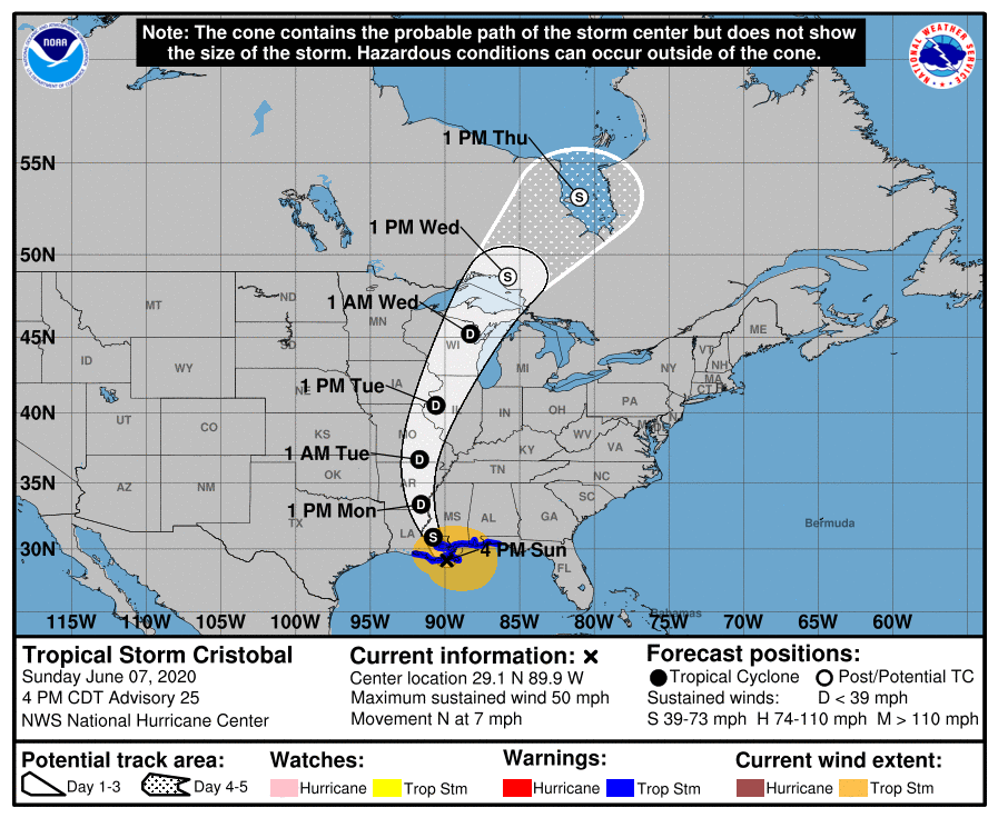
Cristobal is forecast to move across southeastern Louisiana this afternoon through Monday morning, and northward across Arkansas and Missouri Monday afternoon into Tuesday. From there, Cristobal is expected to move north, bringing gusty winds and heavy rain across Missouri, Iowa, Wisconsin, Minnestota, and central Canada later Tuesday into late Wednesday. On the current forecast track from the National Hurricane Center, Cristobal will be located in James Bay in central Canada by Thursday.
For now, though, Cristobal is bringing life-threatening hazards of storm surge, damaging winds, flooding rains, tornadoes, and rough surf to the Gulf Coast.
The combination of a dangerous storm surge and the tide will cause normally dry areas near the coast to be flooded by rising waters moving inland from the shoreline. The water could reach up to 3-5′ heights above ground near the mouth of the Mississippi River to Ocean Springs, Mississippi including Lake Borgne. The deepest water will occur along the immediate coast in areas of onshore winds and will likely extend along the coast well to the east of the center. Surge-related flooding depends on the relative timing of the surge and the tidal cycle, and can vary greatly over short distances. For information specific to your area, please see products issued by your local National Weather Service forecast office.
Tropical storm wind conditions are expected within the Tropical Storm Warning area along the northern Gulf coast through tonight.
Cristobal is expected to produce storm total rainfall accumulations of 4-8″ across portions of the central to eastern Gulf Coast into the Lower Mississippi Valley, with isolated amounts up to a foot of rain. Rainfall totals of 2-4″ with local amounts to 6″ are expected across portions of the Mid to Upper Mississippi Valley and Northern Plains near and in advance of Cristobal. This rainfall will likely lead to flash flooding and widespread flooding on smaller streams across portions of the central Gulf Coast into the Lower Mississippi Valley. New and renewed significant river flooding is possible along the central Gulf Coast and into the Mississippi Valley.
A few tornadoes are possible today and tonight across eastern Louisiana, southern Mississippi, southern Alabama, and northern Florida. Tornadoes spawned by landfalling tropical cyclones like this are often small but potent; several can also spin-up in a short amount of time.
Swells generated by Cristobal will affect portions of the northern and eastern Gulf coast during the next couple of days. Because these swells are likely to cause life threatening surf and rip current conditions, people are encouraged to avoid swimming in the Gulf until seas have completely relaxed well after Cristobal’s landfall.
