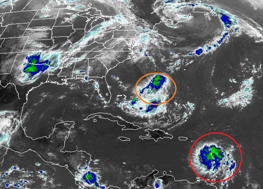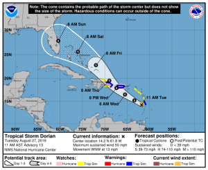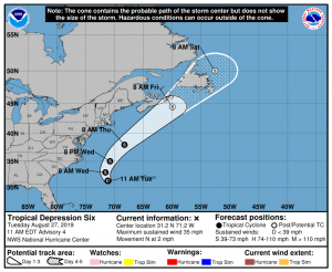
Tropical Storm Dorian continues to spin about in the Caribbean; over time, it could brush by Puerto Rico and Hispaniola before making a direct impact on the U.S. East Coast. While inches north and west over time, a new area of disturbed weather has been classified as Tropical Depression #6 by the National Hurricane Center (NHC) in Miami, Florida. This disturbance is forecast by the NHC to become a tropical storm soon; when it does so, it would be named Erin.
Due to threats associated with Dorian, several watches and warnings are in effect. The government of the Dominican Republic has issued a Tropical Storm Warning from Isla Saona to Samana. The Tropical Storm Warning has been discontinued for St. Vincent and the Grenadines. The Tropical Storm Watch has been discontinued for Grenada and its dependencies. A Hurricane Watch is in effect for Puerto Rico and for the Dominican Republic from Isla Saona to Samana. A Tropical Storm Warning is in effect for Martinique, Puerto Rico, and the Dominican Republic from Isla Saona to Samana. A Tropical Storm Watch is in effect for Dominica, Saba and St. Eustatius, and the Dominican Republic from Isla Saona to Punta Palenque and from Samana to Puerto Plata. Due to the close proximity to the storm track, people in the Virgin Islands should also closely monitor Dorian.
A Hurricane Watch means that hurricane conditions are possible within the watch area. A watch is typically issued 48 hours before the anticipated first occurrence of tropical-storm-force winds, conditions that make outside preparations difficult or dangerous. A Tropical Storm Warning means that tropical storm conditions are expected somewhere within the warning area within 36 hours. A Tropical Storm Watch means that tropical storm conditions are possible within the watch area, generally within 48 hours.
As of the last advisory, the center of Tropical Storm Dorian was located by data from an Air Force Reserve reconnaissance aircraft and the Martinique radar near latitude 14.2 North, longitude 61.8 West. Dorian is moving toward the west northwest near 13 mph, and this motion is expected to continue through tonight, followed by a turn toward the northwest on Wednesday. On the forecast track, the center of Dorian will move across the eastern and northeastern Caribbean Sea during the next few days, passing near or south of Puerto Rico on Wednesday, move near or over eastern Hispaniola Wednesday night, and move north of Hispaniola on Thursday. On Thursday night and Friday, the center of Dorian is forecast to move near the Turks and Caicos and southeastern Bahamas.

Maximum sustained winds remain near 50 mph with higher gusts. Slow strengthening is forecast during the next 48 hours, and Dorian is forecast by the NHC to be near hurricane strength when it moves close to Puerto Rico and eastern Hispaniola. For now, tropical-storm-force winds extend outward up to 45 miles from the center. The estimated minimum central pressure is 1005 mb or 29.68 inches of mercury.
Dorian will continue to bring heavy rain, gusty winds, and rough surf to those in its path. Dorian is expected to produce 3-6″ of rain with isolated 10″ amounts in Martinique to Saint Vincent; 1-3″ is expected in the Grenadines to Grenada; 1-4″ is expected from Guadeloupe to Dominica; 4-6″ with isolated 8″ amounts are expected in Puerto Rico; 1-3″ with isolated 4″ amounts are expected on the U.S. Virgin Islands. These amounts could create life-threatening flash floods. Tropical storm conditions are occurring in portions of the tropical storm warning area in the Lesser Antilles and these conditions are expected to subside later today. Tropical storm conditions are expected and hurricane conditions are possible in Puerto Rico on Wednesday and in portions of the Dominican Republic late Wednesday and Thursday. Swells generated by Dorian are affecting portions of the Lesser Antilles and they should continue during the next several hours. Swells are expected to increase along the southern coasts of Puerto Rico and Hispaniola on Wednesday and they could cause life-threatening surf and rip current conditions.
The latest forecast track from the NHC brings Dorian to the central east coast of Florida by Sunday morning. It is still too early to say with a high degree of confidence this will occur or how strong Dorian will be if/when it does so. Residents in Florida and the U.S. East Coast should make sure they have their Hurricane Action Plan in order; it may become necessary to act on it this weekend.

While Dorian could become an east coast threat, the storm that’s becoming Erin shouldn’t be. Tropical Depression Six is forecast by the NHC to become a tropical storm by Wednesday morning. The storm should parallel the U.S. East Coast this week, perhaps impacting Cape Breton Island, Nova Scotia, and Newfoundland in the Canadian Maritimes by the weekend. While no direct impacts from this system are expected on the U.S. coast, rough surf and rip currents are possible throughout the coastline all week and into the weekend.