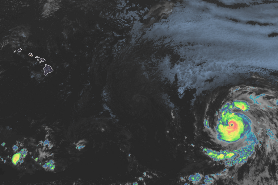
The tropics around North America have sprung to life after taking a quiet pause last week. Hurricane Douglas has gone through a rapid intensification period and is now a Major Category 3 hurricane; it is expected to impact Hawaii this weekend. While Douglas is impacting Hawaii, Hanna could be impacting Texas. Now just a Tropical Depression, the National Hurricane Center believes a disturbance in the Gulf of Mexico will become a tropical storm, eventually making landfall on the Gulf coast over the weekend too. Lastly, Gonzalo continues to grow and is forecast to become a hurricane. Over time, computer forecast models suggest it too will strike the U.S. coastline, making it the third potential landfall within a week.
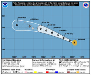
The greatest threat of the bunch for now is Hurricane Douglas. In the latest advisory from the National Hurricane Center (NHC) in Miami, Florida, Douglas was located at 13.1N 134.0W, roughly 1,470 miles east south east of Hilo, Hawaii. Maximum sustained winds are now up to 120 mph while the estimated minimum central pressure is down to 967 mb or 28.56 inches. Douglas is moving west north west at 17 mph, fast for eastern and central Pacific hurricanes.
The NHC believes Douglas could gain additional strength over the next 24 hours. Beyond that, Douglas will be moving into an environment with cooler water temperatures, more dry air, and more wind sheer. Due to those conditions, Douglas is forecast to weaken substantially before arriving in Hawaii. However, Douglas could still be a strong tropical storm or hurricane by the time it arrives in Hawaii on Sunday.

The strongest storm to strike Hawaii on record was Tropical Storm Iselle in 2014. That storm created a significant amount of wind damage and flash flooding on Hawaii, creating more than $140 million in damages even though it was only a 60 mph tropical storm at landfall. Douglas has the potential to be even larger and stronger than Iselle. As such, residents there are being urged by Hawaii Governor David Ige to act on their hurricane action plans now. This includes making sure families have at least 2 weeks worth of food, water, and medicine to sustain themselves should there be significant power failures or prolonged port closures in the state. Governor Ige also reminds residents that the COVID-19 pandemic continues; residents should practice safe social distancing in shelters and be stocked with hand sanitizers and masks if they evacuate.
There are no hurricane watches up for Hawaii yet, but that could change in the coming days as the storm approaches the Aloha State.
There are Tropical Storm Watches up, however, for portions of the Texas Gulf coast. Tropical Depression #8 formed on Wednesday in the central Gulf of Mexico. While it hasn’t changed much in terms of strength over the last 12 hours, that is expected to change over the next 12-24 hours. The NHC expects Tropical Depression #8 to grow into the next named tropical cyclone of the season; when that happens, it’ll be named Tropical Storm Hanna. With tropical storm conditions expected on the Texas coast this weekend, the NHC has issued Tropical Storm Watches there from Port Mansfield to High Island.
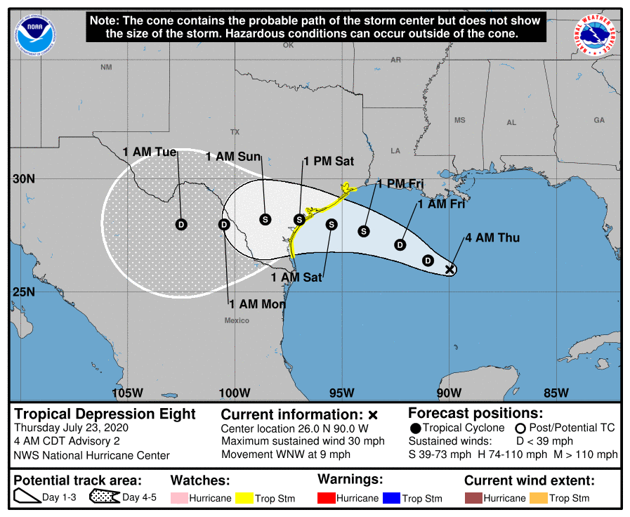
A Tropical Storm Watch means that tropical storm conditions are
possible within the watch area, generally within 48 hours. According to the NHC, interests elsewhere along the Texas and Louisiana coast should monitor the progress of this system.
In the last advisory from the NHC, Tropical Depression #8 was at 26.0N 90.0W which is roughly 425 miles east south east of Port O’Connor Texas. Maximum sustained winds are 30 mph while the estimated minimum central pressure is 1009 mb or 29.80 inches. This system is moving west north west at 9 mph.
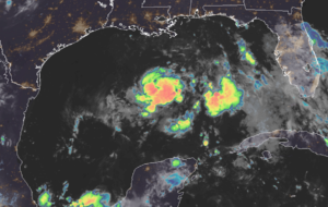
As Hanna, this system is expected to bring wind, heavy rain, and rough surf to Texas this weekend. The NHC says tropical storm conditions are possible within the watch
area by late Friday. They also say that the system is expected to produce 3-5″ of rain with isolated maximum totals of 8″ through Monday along the Gulf Coast from Louisiana to the Lower Texas Coast, and inland through south-central Texas and the Rio Grande Valley. These rains may result in flash flooding across the west-central Gulf Coast into portions of south Texas. Swells generated by the storm are expected to increase and affect much of the Texas and Louisiana coasts in a day or two. These swells are likely to cause life-threatening surf and rip current conditions; even experienced swimmers and surfers should avoid the Gulf of Mexico until the storm is long gone.
Lastly, Tropical Storm Gonzalo continues to spin about in the Atlantic. In the latest advisory from the NHC, it was located at 10.0N 47.0W which is roughly 970 miles east of the Southern Windward Islands. Maximum sustained winds are 65 mph while the estimated minimum central pressure is 997 mb or 29.44 inches. Gonzalo is moving west at 12 mph.
For now, a Hurricane Watch is in effect for Barbados. A Hurricane Watch means that hurricane conditions are possible within the watch area. A watch is typically issued 48 hours before the anticipated first occurrence of tropical-storm-force winds, conditions that make outside preparations difficult or dangerous. The NHC says that interests in the Windward Islands should monitor the progress of this system.
According to the NHC, additional watches or warnings will likely be required for more islands later today.
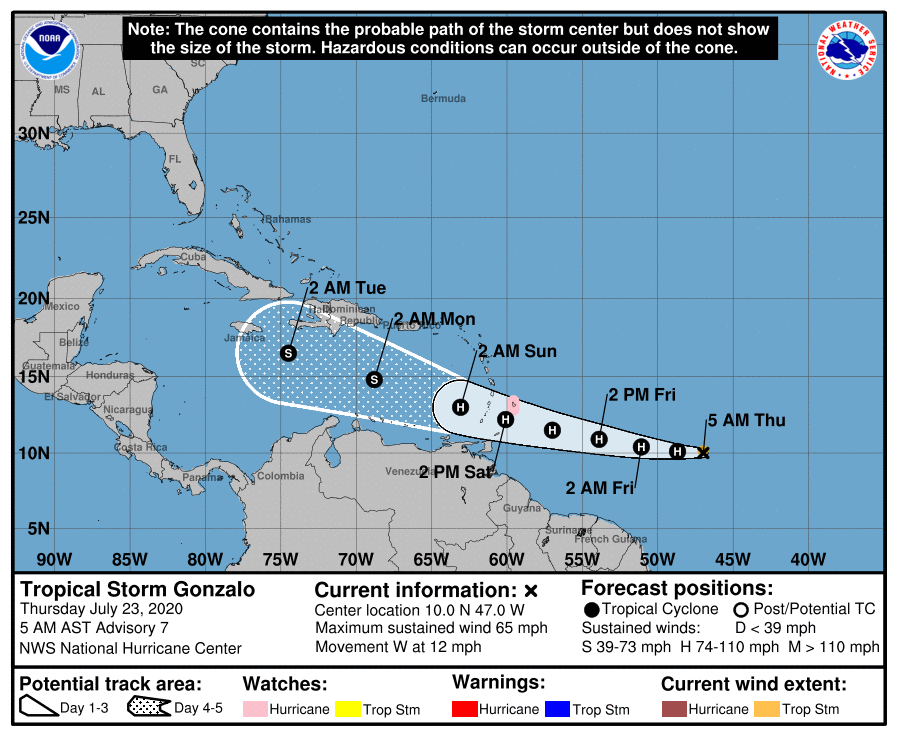
Gonzalo is forecast to pursue a general westward motion at a faster forward speed in the coming days, followed by a turn toward the west-northwest on Saturday. On the forecast track, the center of Gonzalo would approach the Windward Islands late Friday and Saturday.
Further strengthening is forecast during the next couple of days, and Gonzalo is expected to become a hurricane later today.
Computer forecast guidance suggests that Gonzalo could impact the United States too within a week of the landfalls of Douglas and Hanna. However, it is still too early to say with certainty where the storm will go over time.
Both the Central Pacific and Atlantic Hurricane Basin hurricane seasons run now through the end of November.