• Skip to primary navigation
  • Skip to main content
  • Skip to primary sidebar

Weatherboy

Weatherboy Weather News, Maps, RADAR, Satellite, and Forecasts.

  • Local
  • Earth Science News
  • RADAR
  • Current Warnings
  • Satellite
  • Current Maps
  • Forecast Maps
  • Video

Dread for Fred? New Tropical Cyclone Takes Shape

by Weatherboy Team Meteorologist - August 9, 2021

Computer models suggest the developing tropical cyclone could impact the U.S. over time.  Image: tropicaltidbits.com
Computer models suggest the developing tropical cyclone could impact the U.S. over time. Image: tropicaltidbits.com


A new tropical cyclone appears to be taking shape northeast of Barbados, and some may begin having some dread for the next storm to be named: Fred. The National Hurricane Center (NHC) in Miami, Florida has been tracking the disturbance for the last few days; they now say there is an 80% chance that it will become a tropical cyclone, perhaps impacting U.S. interests over time as a named storm.

Current Tropical Outlook map shows the 2 systems the National Hurricane Center is tracking in the Atlantic Hurricane Basin.  Image: NHC
Current Tropical Outlook map shows the 2 systems the National Hurricane Center is tracking in the Atlantic Hurricane Basin. Image: NHC


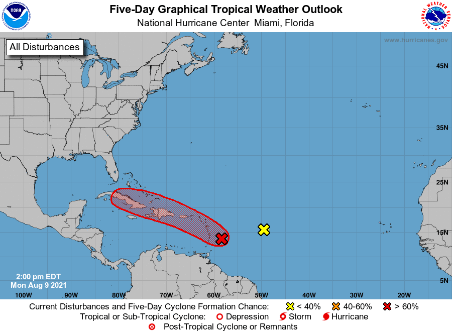
According to the NHC, showers and thunderstorms associated with the area of low pressure located about 100 miles east-northeast of Barbados continue to show signs of organization. However, recent satellite wind data indicates that the system currently lacks a well-defined center. The NHC says environmental conditions are expected to remain conducive for additional development, and a tropical depression is likely to form later today or tonight while the low moves west-northwestward at 10 to 15 mph. The disturbance is forecast to move through portions of the Lesser Antilles tonight, then move near the Virgin Islands and Puerto Rico on Tuesday, and Hispaniola on Wednesday.

The National Hurricane Center believes the system will become a tropical storm with time. When it becomes a named storm, it will be called Fred.  The 1991-2020 average date for 6th Atlantic named storm formation is August 28 and with this storm likely to form soon, it will be more than 2 weeks ahead of normal, illustrating that the 2021 Atlantic Hurricane Season is indeed a busy one.


Because the system is expected to become a tropical storm, the NHC says that Tropical Storm Watches or warnings could be required this afternoon with shorter-than-normal lead times for portions of the Lesser Antilles, the Virgin Islands, and Puerto Rico.

Beyond tropical storm conditions,  heavy rains and flooding are likely for the Leeward Islands, the Virgin Islands, and Puerto Rico.  Heavy rain could create floods, rock slides, and mud slides.

Primary Sidebar

Sponsored Ad

Search

Latest News

  • NTSB Confirms UFO Impact into United Airlines Jet That Injured Pilot
  • Good Weather is Bad for Business: The Home Depot Says Quiet Hurricane Season Hurt
  • Hurricane Season Wraps Up Without Any U.S. Landfalls
  • NASA Releases Very Blurry and Pixelated Images of 3I/Atlas, Fueling More Alien Spacecraft Talk
  • Shock Update: NASA Confirms the Earth Now Has TWO Moons
  • Strong Earthquake Strikes Venezuela Coast; No U.S. East Coast Tsunami Threat
  • Winter Storm to Bring 4″+ Snow to Hawaii Today
  • NASA to Hold Special Media Event Wednesday to Discuss Interstellar Mystery Object 3I/Atlas
About | Careers | Contact | Contests
Terms | Privacy | Ad Choices
Weatherboy is a (R) Registered Trademark of isarithm LLC, All Rights Reserved.
All content herein is Copyright by Isarithm LLC 1997-2022

Insert/edit link

Enter the destination URL

Or link to existing content

    No search term specified. Showing recent items. Search or use up and down arrow keys to select an item.