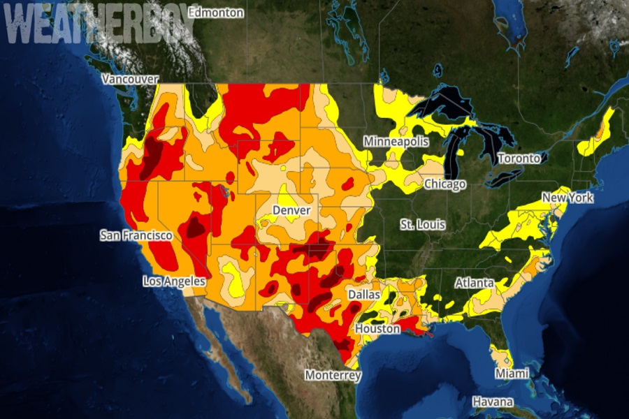
In the latest Drought Monitor map release this week, drought conditions are getting worse across large parts of the United States. While April began with heavy rains in parts of the Midwest, South, and Southeast, which brought some improvement to drought conditions there, drought conditions expanded and intensified across the West and Hawaii. Drought conditions are so bad that many locations in the West are setting record for the driest three month period (January-March) on record.
In addition to bone-dry conditions in the West, conditions are very dry across New England and portions of the Mid Atlantic. Because only near-normal precipitation fell in New England, there’s been no change in the long term drought that is impacting northern Vermont, New Hampshire. According to the Drought Monitor update, abnormal dryness has expanded over the Mid-Atlantic short-term where precipitation deficits, stream flow measurements and soil moisture conditions have fallen below normal. Southeastern Pennsylvania and southern New Jersey have seen moderate drought conditions expand there.
Even outside of the continental U.S., drought conditions are getting worse. In Hawaii, Severe Drought persists across much of the state, with Extreme Drought conditions in the northwestern Big Island communities of Waikoloa and Kawaihae.
One place not seeing any drought is Alaska. Alaska remains drought-free in the latest Drought Monitor update. Despite temperatures running well above-normal in recent weeks, snowpack is still well above-normal and in some cases at record high levels.
The U.S. Drought Monitor is a map released every Thursday, showing parts of the U.S. that are in drought. The map uses five classifications: abnormally dry (D0), showing areas that may be going into or are coming out of drought, and four levels of drought: moderate (D1), severe (D2), extreme (D3) and exceptional (D4). Since its creation in 1999, the Drought Monitor product is produced jointly by the National Drought Mitigation Center (NDMC) at the University of Nebraska-Lincoln, the National Oceanic and Atmospheric Administration (NOAA), and the U.S. Department of Agriculture (USDA). The NDMC hosts the web site of the drought monitor and the associated data, and provides the map and data to NOAA, USDA and other agencies.
