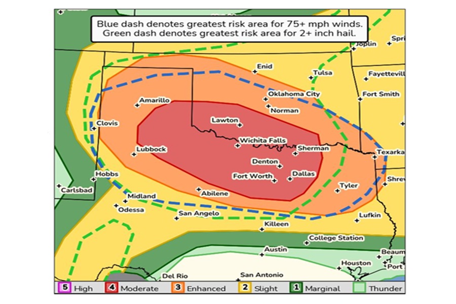
A derecho with 80-100 mph winds is expected to smash through portions of Oklahoma and Texas today. The National Weather Service is warning residents to brace for impact: 80-100 mph winds along with large hail over 2″ in diameter and flash-flooding rains are all possible for areas that include the Dallas-Ft. Worth metro area.
A derecho is a widespread, long-lived windstorm associated with a band of rapidly moving thunderstorms or showers, often causing significant damage and destruction. Unlike tornadoes, derecho winds move in a straight line and can reach hurricane-force speeds, causing widespread damage to trees, power lines, and even buildings.
Technically, a derecho is defined as a wind damage swath extending more than 240 miles and including wind gusts of at least 58 mph along most of its length. The term “derecho” is Spanish for “straight” or “direct,” reflecting the straight-line nature of the wind damage.
“A severe weather outbreak is expected across the southern Plains today, including southern Oklahoma and much of northwest and North Texas,” warns the National Weather Service. ” A few tornadoes, destructive wind gusts of 80-100 mph, and giant hail up to 3-5 inches in diameter are likely.”
The National Weather Service has advice for people in the path of this derecho event. “Review your severe weather safety procedures for the possibility of dangerous weather today. Stay tuned to NOAA Weather Radio, weather.gov, or other media for watches and warnings.”
The National Weather Service is also reminding people of the difference between a watch and warning for severe storms: “A watch means that conditions are favorable for severe thunderstorms over the next several hours. If a severe thunderstorm warning is issued for your area, move to a place of safety, ideally in an interior room on the lowest floor of a sturdy building.”
A shortwave trough will move out of the Rockies and interact with a southward advancing cold front Sunday to produce thunderstorms across southwest Kansas into northwest Oklahoma. Now, extreme instability and modest deep-layer shear will favor supercell thunderstorms capable of producing very large hail, damaging wind gusts and tornadoes.
The latest HRRR model run shows how the MCS will unfold across Oklahoma/Texas today: pic.twitter.com/4QCFWJfao7
— the Weatherboy (@theWeatherboy) June 8, 2025
According to the National Weather Service, this activity is expected to rather quickly grow upscale into a forward propagating mesoscale convective system capable of extremely damaging straight-line winds, perhaps in the 80-100 mph range, as it tracks southeast across much of the area Sunday afternoon and evening.
A mesoscale convective system, or MCS for short, involve organized clusters of thunderstorms that exist on a scale larger than individual storms, but smaller than extratropical cyclones. The term “complex” often refers to the variety of storm types and structures within the overall system.
Right now, it appears the most likely track would take it across west central into perhaps central Oklahoma then southeast impacting much of southern Oklahoma then south into north Texas. Very heavy rainfall will also accompany this complex of storms. The National Weather Service says its forward motion should limit the overall flash flood risk, but some isolated flooding will be possible, especially given antecedent conditions.
