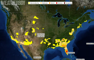
In the latest Drought Monitor update, drought conditions have improved almost everywhere in the United States except for Florida. In the 17 year history of the Drought Monitor index, the drought outlook has never been better with less than 5% of the country under a drought classification. The last time the Drought Monitor looked this good was July 2010.
The U.S. Drought Monitor is produced through a partnership between the National Drought Mitigation Center at the University of Nebraska-Lincoln, the United States Department of Agriculture, and the National Oceanic and Atmospheric Administration.
An intense storm developed over the central Plains and moved through the Midwest last week, bringing with it torrential rains and thunderstorms on the front side and heavy, wet snow on the back side. A wide swath of the country from eastern Oklahoma through Arkansas, Missouri and into Illinois recorded over 5 inches of rain with the event. Portions of western Kansas and the Oklahoma Panhandle recorded several inches of snow, with some places over a foot. The Southeast remained dry as well as much of the Southwest.
Heavy rain that fell over portions of the Mid Atlantic and Northeast yesterday will help squash flood concerns there.

Unfortunately, conditions continue to get worse for the Sunshine State. Florida is living up to its nickname, with more sunshine than rain. The end result is an Extreme Drought classification for portions of central Florida. Georgia still has drought issues too; the northern part of the state is seeing Extreme Drought too.
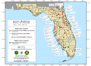
The dry conditions in Florida are creating significant fire issues. The Florida Forest Service reports there are more than 1,900 active fires in the state consuming thousands of acres of land.
In the current weather pattern, no relief is expected for the southeast in the short-term.