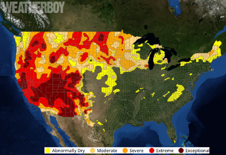
While extremely heavy rains flooded portions of the East in recent days, an exceptional drought is getting worse across the western United States. The latest Drought Monitor update was released yesterday and the map looks worse than before, with large parts of the west under “Extreme” or “Exceptional” drought status. The U.S. Drought Monitor is produced through a partnership between the National Drought Mitigation Center at the University of Nebraska-Lincoln, the United States Department of Agriculture, and the National Oceanic and Atmospheric Administration.
Mid-level ridging has resulted in much above-normal temperatures for the western third of the continental United States, making drought conditions worse across the Pacific Northwest, northern Great Basin, Northern Rockies, and along the Front Range. Above-normal temperatures also pushed into the northern High Plains, warranting further deterioration of drought conditions in locations where rainfall remained below-average for the week. The central and eastern Corn Belt was a battle ground of sorts, with some locations seeing improvement with this week’s heavy rainfall, while other locations missed out, adding to dry conditions there. While a robust monsoon flow from the southwest helped moisten parts of New Mexico and west Texas, much of the southwest saw dry conditions continuing, with some areas of extreme drought worsening to exceptional drought status. In addition to exceptional drought, a high risk of fire danger remains there too.
Tropical Storm Elsa did help improve some abnormally dry areas in the east, especially near the Virginia / North Carolina border. And while a 100 year flood struck portions of east central Pennsylvania and central New Jersey, abnormally dry conditions continue to persist in portions of northeastern Pennsylvania.