
An earthquake struck off the coast of South Carolina this morning and due to the weak intensity of the quake, there is no tsunami threat along the U.S. East Coast at this time. According to USGS, at 3:28 am early this morning, a weak magnitude 2.0 earthquake just east of Charleston, South Carolina over the open waters of the Atlantic Ocean. The earthquake’s epicenter was 30 miles from Charleston and had a depth of 10.5 km.
According to USGS, earthquakes with a magnitude of 2.0 or less are rarely felt or heard by people, but once they exceed 2.0 more and more people can feel them. While damage is possible with magnitude 3.0 events or greater, significant damage and casualties usually don’t occur until the magnitude of a seismic event rises to a 5.5 or greater rated event.
Tsunamis are giant waves caused by earthquakes or volcanic eruptions under the sea. Out in the depths of the ocean, tsunami waves do not dramatically increase in height. But as the waves travel towards land, they build up to higher and higher heights as the depth of the ocean decreases. The speed of tsunami waves depends on ocean depth rather than the distance from the source of the wave. Tsunami waves may travel as fast as jet planes over deep waters, only slowing down when reaching shallow waters. While tsunamis are often referred to as tidal waves, this name is discouraged by oceanographers because tides have little to do with these giant waves.
According to USGS, an earthquake typically needs to be at least magnitude 6.5 to 7.0 or higher to generate a significant tsunami. While smaller quakes can create waves, they rarely cause major waves. The risk of a destructive, far-reaching tsunami increases significantly with earthquakes of magnitude 7.6 or greater, particularly when they cause vertical displacement of the seafloor. Today’s earthquake didn’t meet any criteria for a tsunami to form.
While there has been an uptick in seismic activity in South Carolina in recent weeks, today’s earthquake was the first to strike off the coast. In the last 30 days, there were 8 other earthquakes in South Carolina and all were centered north and west of Charleston or north and west of Columbia.
According to the South Carolina Emergency Management Division (SCEMD), there are approximately 10-15 earthquakes every year in South Carolina, with most not felt by residents; on average, only 3-5 are felt each year. Most of South Carolina’s earthquakes are located in the Middleton Place-Summerville Seismic Zone. The two most significant historical earthquakes to occur in South Carolina were the 1886 Charleston-Summerville quake and the 1913 Union County quake. The 1886 earthquake in Charleston was the most damaging earthquake to ever occur in the eastern United States; it was also the most destructive earthquake in the U.S. during the 19th century.
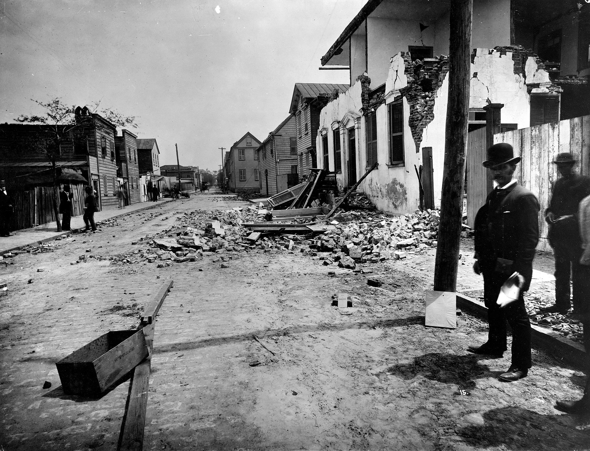
The 1886 earthquake struck at about 9:50 pm on August 31; it was estimated to have been rated a magnitude 6.9 – 7.3 seismic event. The earthquake was felt as far away as Boston, Massachusetts to the north, Chicago, Illinois and Milwaukee, Wisconsin, to the northwest, and New Orleans, Louisiana to the south. The earthquake energy even traveled as far away as Cuba and Bermuda, where some shaking was felt too. The initial earthquake lasted about 45 seconds.
The 1886 Charleston earthquake was responsible for 60 deaths and over $190 million (in 2023 dollars) in damage. The area of major damage extended out 60-100 miles from the epicenter, with some structural damage even reported in central Alabama, Ohio, eastern Kentucky, southern Virginia, and western West Virginia from the initial quake.
A study published in 2008 in the Journal of Geotechnical and Geoenvironmental Engineering hypothesized that if such an earthquake were to strike the region today, it would lead to approximately 900 deaths, 44,000 injuries, and damages in excess of $20 billion in South Carolina alone.
