• Skip to primary navigation
  • Skip to main content
  • Skip to primary sidebar

Weatherboy

Weatherboy Weather News, Maps, RADAR, Satellite, and Forecasts.

  • Local
  • Earth Science News
  • RADAR
  • Current Warnings
  • Satellite
  • Current Maps
  • Forecast Maps
  • Video

Earthquakes Rock Puerto Rico & Dominican Republic; No Tsunami Threat

by Weatherboy Team Meteorologist - April 22, 2021

A series of earthquakes, indicated by the dots on this map, have struck the area around Puerto Rico and the Dominican Republic over the last 24 hours. Image: USGS


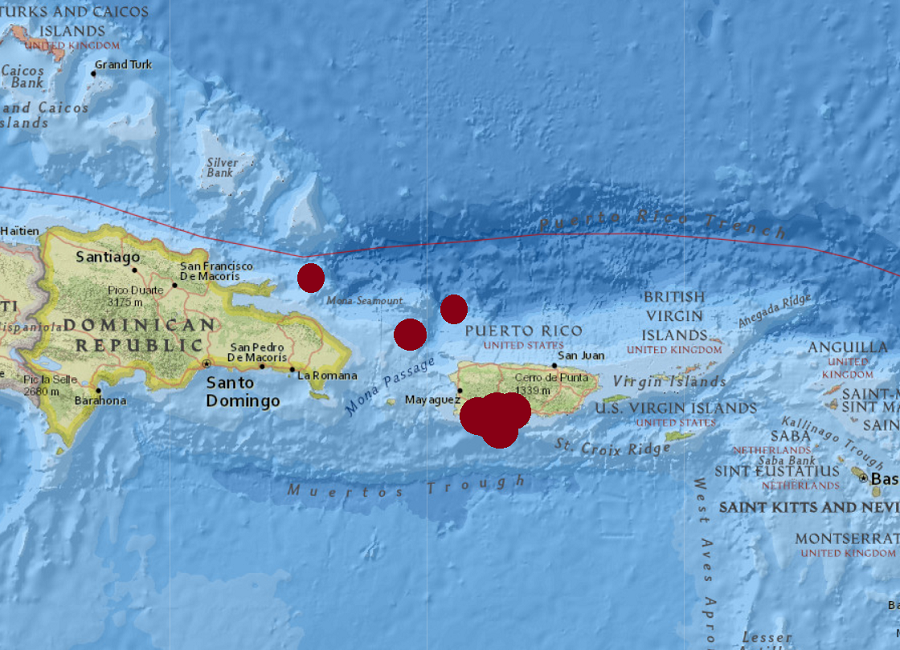
A series of earthquakes rocked both Puerto Rico and the Dominican Republic today; while they were felt through the region, they weren’t strong enough to produce a tsunami. As such, there is no tsunami threat as of now.

Of the 10 earthquakes that struck in the last 24 hours, 7 were a noticeable 2.5 or greater magnitude. The strongest, a 3.7, struck 2.5 miles east-southeast of La Parquera, Puerto Rico just after 1pm ET.  An hour before. a 3.4 struck 38 miles north of San Antonio. Over night, a 3.1 and 3.4 earthquake also struck the south coast of Puerto Rico. A 3.7 also struck 30 miles northeast of Miches, Dominican Republic.

While some earthquakes struck north of the Dominican Republic and Puerto Rico, most struck along the south coast of Puerto Rico where a strong earthquake hit  in 2020. These earthquakes are likely continued aftershocks from that strong earthquake that struck the island in January 2020. That 6.4 created extensive damage in Puerto Rico, including widespread power failures across much of the island.  An earthquake swarm started here in December 2019 and unrest has continued since.


The view of the La Soufriere volcano erupting on the Caribbean island of St. Vicent, taken at 11:08 am this morning. Image: Richard Robertson / University of the West Indies Seismic Research Centre
The view of the La Soufriere volcano erupting on the Caribbean island of St. Vincent, taken at 11:08 am this morning. Image: Richard Robertson / University of the West Indies Seismic Research Centre

These earthquakes are occurring near  the northern edge of the Caribbean Plate, a mostly oceanic tectonic plate underlying Central America and the Caribbean Sea off of the north coast of South America.  The Caribbean Plate borders the North American Plate, the South American Plate, the Nazca Plate, and the Cocos Plate. The borders of these plates are home to ongoing seismic activity, including frequent earthquakes, occasional tsunamis, and sometimes even volcanic eruptions.

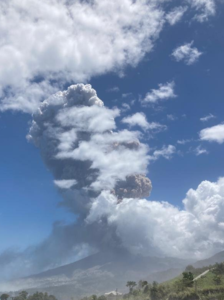
While the La Soufriere volcano continues to erupt on the island of St. Vincent, that eruption is not directly tied to any seismic activity happening on the other side of the Caribbean Plate near Puerto Rico.

Primary Sidebar

Sponsored Ad

Search

Latest News

  • Houston is Ground Zero For Flooding Event
  • Legendary TV Meteorologist Who Appeared in “Twister” Dies
  • Earthquake Rattles Los Angeles
  • Tropical Storms Barbara and Cosme Forecast to Weaken
  • Barbara Becomes Hurricane; Cosme Will Become One Soon Too
  • Tornado Risk Today in Pennsylvania, New York, Ohio, West Virginia, Mississippi, & Alabama
  • Tornadoes Possible in Delaware, Maryland, and Virginia Sunday
  • Derecho with 100 mph Winds Expected to Smash Through Oklahoma and Texas Today
About | Careers | Contact | Contests
Terms | Privacy | Ad Choices
Weatherboy is a (R) Registered Trademark of isarithm LLC, All Rights Reserved.
All content herein is Copyright by Isarithm LLC 1997-2022