Are you and your local officials prepared for a potential destructive tsunami along the US east coast? An exercise scheduled for March 22 will help bring awareness to the threat, allowing local officials and residents to be ready when an actual threat arrives. (If any real tsunami threat occurs during the time period of the exercise, the exercise will be terminated.)
Tsunamis are giant waves caused by earthquakes or volcanic eruptions under the sea. Out in the depths of the ocean, tsunami waves do not dramatically increase in height. But as the waves travel towards land, they build up to higher and higher heights as the depth of the ocean decreases. The speed of tsunami waves depends on ocean depth rather than the distance from the source of the wave. Tsunami waves may travel as fast as jet planes over deep waters, only slowing down when reaching shallow waters. While tsunamis are often referred to as tidal waves, this name is discouraged by oceanographers because tides have little to do with these giant waves.
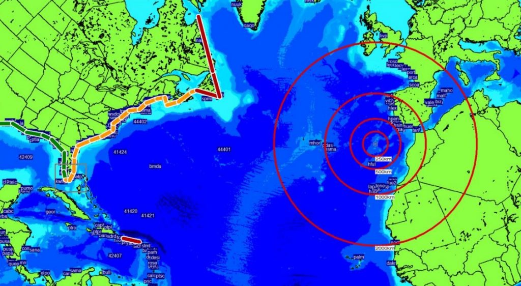
The National Oceanic and Atmospheric Administration (NOAA) and the U.S. National Tsunami Hazard Mitigation Program (NTHMP) are providing the framework for the LANTEX17 tsunami exercise, which is being conducted to assist tsunami preparedness efforts throughout the Atlantic region. Recent earthquakes and their associated tsunamis, such as those in Samoa (2009), Haiti (2010), Chile(2010, 2015), and Japan (2011) attest to the importance of proper planning for tsunami response. Similar recent exercises in the Pacific and Caribbean Basins have proven effective in strengthening preparedness levels of emergency management organizations. This exercise will provide simulated tsunami alert messages from the NOAA/NWS National Tsunami Warning Center (NTWC) for the eastern coasts of Canada and the United States as well as Puerto Rico and the US/British Virgin Islands.
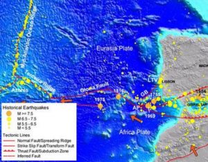
The area where the simulation will occur is not a stranger to violent tsunami-generating earthquakes. The Africa-Eurasia plate boundary extends from the Mid-Atlantic ocean ridge triple junction near the Azores eastward to the Strait of Gibraltar. Here, the Africa plate rotates counterclockwise relative to the Eurasia plate at a rate of about 4 mm/year. While that motion is relatively slow compared to other active plate boundaries found elsewhere around the world, several large magnitude earthquakes have occurred here. In 1755, there was a 7.6 magnitude quake there; in 1816, a magnitude 7.6 quake struck here; in 1969, a 7.9 earthquake struck here.
A modeled tsunami from the simulated earthquake would impact the east coast of North America, with some areas impacted more than others. The model indicated a significant tsunami along the Canadian and Caribbean coasts, but with less impact elsewhere. Every earthquake has different characteristics, so what’s modeled in this simulation may be very different when a real earthquake does strike this region in the future.
After the simulated tsunami, test Tsunami Warning and Tsunami Advisory messages will be issued for residents of the U.S. East Coast, eastern Canada, and the Caribbean.
Tsunami Warning
A tsunami warning is issued when a tsunami with the potential to generate widespread inundation is imminent, expected, or occurring. Warnings alert the public that dangerous coastal flooding accompanied by powerful currents is possible and may continue for several hours after initial arrival. Warnings alert emergency management officials to take action for the entire tsunami hazard zone. Appropriate actions to be taken by local officials may include the evacuation of low-lying coastal areas, and the re-positioning of ships to deep waters when there is time to safely do so. Warnings may be updated, adjusted geographically, downgraded, or canceled. To provide the earliest possible alert, initial warnings are normally based only on seismic information.
Tsunami Advisory
A tsunami advisory is issued when a tsunami with the potential to generate strong currents or waves dangerous to those in or very near the water is imminent, expected, or occurring. The threat may continue for several hours after initial arrival, but significant inundation is not expected for areas under an advisory. Appropriate actions to be taken by local officials may include closing beaches, evacuating harbors and marinas, and the repositioning of ships to deep waters when there is time to safely do so. Advisories are normally updated to continue the advisory, expand/contract affected areas, upgrade to a warning, or cancel the advisory.
For more information on the U.S. Tsunami Warning system, visit www.tsunami.gov.
For more information on the NTHMP, see nthmp.tsunami.gov.
