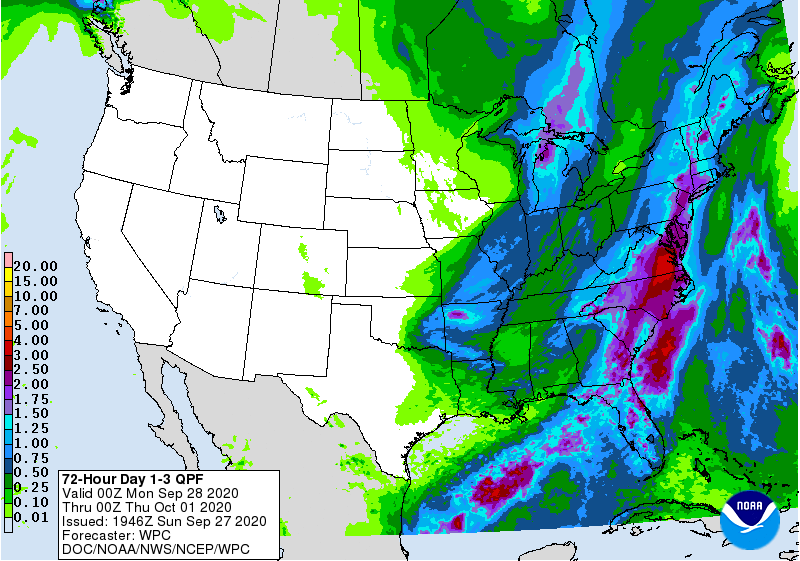
This week’s weather pattern will keep conditions very wet along the eastern United States, prompting some concerns about flooding after a stretch of very dry weather and drought conditions for portions of the northeast.
Light to moderate rain will fall over portions of the eastern United States over the next 48 hours. Rain should be light enough not to create any river rises nor flash flood concerns. However, heavy rain will develop later Tuesday evening into Wednesday, elevating the risk for excessing rainfall and localized flooding over a broad area of the East Coast.
Just how much heavy rain falls on Wednesday remains questionable, but the situation warrants watching should river flooding become a threat.
Due to the heavy rain threat, the National Weather Service says spotter activation may be needed. Storm spotters are encouraged to relay information about observed severe weather and flooding conditions to the National Weather Service while following all local, state, and CDC guidelines in place due to the ongoing pandemic.

The reason for the wet weather is a series of lows and fronts that’ll march from west to east. Weak low pressure off the Mid Atlantic coast today, associated with the remnants of Tropical Storm Beta, will track into New England overnight. To the west, a cold front will move into Pennsylvania on Monday. With areas of low pressure riding north along the cold front, the system will slow down on Tuesday and Wednesday as it moves through eastern United States. Due to this slow-down, heavier precipitation is expected.
While conditions will improve later Wednesday into early Thursday, yet another cold front will arrive Thursday night into Friday, bringing another round of precipitation to the eastern United States. In the wake of Friday’s frontal passage, cooler air will settle
in over the region into next weekend making it feel much more like autumn.
