Elsa, now a tropical storm, is forecast to strike Florida on Monday and Tuesday before moving up the southeast coast, bringing wind-whipped rains to portions of Georgia, the Carolinas, and Virginia. Beyond there, Elsa or its remnants are expected to dump heavy rains over portions of the Mid Atlantic and New England coasts with time.
According to the National Hurricane Center (NHC), reports from an Air Force Reserve Hurricane Hunter aircraft investigating the storm and data and imagery provided by the GOES-East weather satellite indicate that Elsa has weakened a bit. While the center was exposed earlier today, it is now located within the northwestern edge of a new convective burst.
Elsa is approaching a weakness in the subtropical ridge caused by a large baroclinic trough over the eastern United States. The global models forecast this trough to move eastward into the Atlantic, but the NHC says that the southern portion is likely to split off and become an upper-level low pressure area over the western Gulf of Mexico, with the subtropical ridge over the Atlantic situated to the east of the this low. This evolution should cause Elsa to slow its current fast forward speed during the next day or so, then turn northwestward in about 36 hours, followed by a general north motion in about 72 hours.
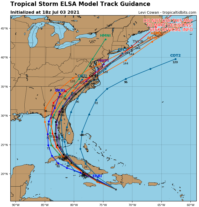
Elsa continues to be affected by northwesterly shear that is at least partly due to the fast forward motion. While the forward speed is forecast to decrease over the next few days, continued westerly shear and land interaction with Cuba, Haiti, and Jamaica are expected to cause additional weakening. Unlike yesterday’s computer forecast guidance that suggested significant intensification, guidance now shows a much weaker system moving through the Caribbean. While some shear is likely to continue when the storm is near or over the eastern Gulf of Mexico, upper-level divergence associated with the aforementioned upper-level low could allow for some re-intensification. Because of that, Elsa could eventually strike Florida as a tropical storm or hurricane.
Although Elsa is now a tropical storm, hurricane warnings remain in effect for portions of the Dominican Republic and Haiti at this time, as conditions have not yet reached their worst there and the possibility that a short-lived re intensification might occur due to a convective burst.
A hurricane warning remains in effect for portions of Haiti and the Dominican Republic, where near-hurricane conditions and dangerous storm surge are expected through this evening.
Widespread heavy rain will move across southern Hispaniola and Jamaica today into Sunday where isolated to scattered flash flooding and mudslides will be possible. Heavy rain will impact the Cayman Islands and Cuba Sunday into Monday, resulting in significant flooding and mudslides over Cuba. As Elsa approaches the Florida Keys and southern Florida early next week, isolated flash flooding and minor river flooding will be possible.
Tropical storm conditions and dangerous storm surge are expected with hurricane conditions possible in portions of eastern Cuba beginning early Sunday, with tropical storm conditions possible in central Cuba Sunday night and Monday.
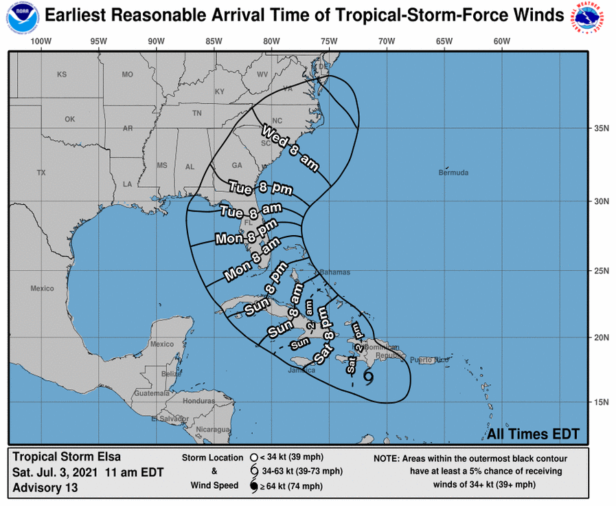
According to the NHC, there is an increasing risk of tropical storm conditions, storm surge, and rainfall impacts beginning Monday in the Florida Keys and the southern Florida Peninsula. This risk will spread northward along the Florida Peninsula through Wednesday and reach the coasts of Georgia and the Carolinas Wednesday and Thursday. However, the NHC adds caution: “uncertainty in the forecast remains larger than usual due to Elsa’s potential interaction with the islands of Hispaniola and Cuba. Interests in Florida and along the southeast U.S. coast should monitor Elsa’s progress and updates to the forecast.”
